Related Research Articles

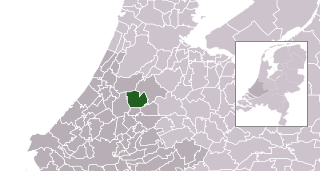
Alphen aan den Rijn is a city and municipality in the western Netherlands, in the province of South Holland. The city is situated on the banks of the river Oude Rijn, where the river Gouwe branches off. The municipality had a population of 112,587 in 2021, and covers an area of 132.50 km2 (51.16 sq mi) of which 6.27 km2 (2.42 sq mi) is water.

Boskoop is a town in the province of South Holland. It was a separate municipality until it merged into Alphen aan den Rijn in 2014. The town had a population of 15,050 in 2012 and covers an area of 7.29 km2 (2.81 sq mi) of which 1.39 km2 (0.54 sq mi) is water. It's the world's biggest joined floriculture area.

Ter Aar is a town and former municipality in the western Netherlands, in the province of South Holland. It is located about 6 km northeast of Alphen aan den Rijn. The town had a population of 9,007 on 1 July 2006.
Alphen may refer to:
Hazerswoude is a former municipality in the Dutch province of South Holland. It contained the towns of Hazerswoude-Dorp and Hazerswoude-Rijndijk, and the villages of Groenendijk and Bent.

The Oude Rijn is a branch of the Rhine delta in the Dutch provinces of Utrecht and South Holland, starting west of Utrecht, at Harmelen, and running by a mechanical pumping station into the North Sea at Katwijk. Its present-day length is 52 kilometres.

Bouches-de-la-Meuse was a department of the First French Empire in the present-day Netherlands. It was named after the mouth of the river Meuse. It was formed in 1810, when the Kingdom of Holland was annexed by France. Its territory corresponded more or less with the present-day Dutch province of South Holland. Its capital was The Hague.
Zwammerdam is a village in the Dutch province of South Holland along Oude Rijn river. It is a part of the municipality of Alphen aan den Rijn, and lies about 6 km southeast of Alphen aan de Rijn. The name derives from a dam built in the Rhine river in 1165 AD by Count Floris III of Holland, to protect the land stream downwards from floods.

Aarlanderveen is a village in the Dutch province of South Holland. It is a part of the municipality of Alphen aan den Rijn, and lies about 4 km east of Alphen aan den Rijn.

Koudekerk aan den Rijn is a village located in the municipality of Alphen aan den Rijn, Netherlands. It is located about 4 km west of the urban centre, in the province of South Holland.

Hogeveen is a hamlet in the Dutch province of South Holland. It is located in the municipality of Alphen aan den Rijn, about 2 km south of Hazerswoude-Dorp.

Leimuiden is a Dutch village in the South Holland municipality of Kaag en Braassem. Leimuiden is located between the Braassemermeer, the Westeinderplassen and the Ringvaart. Leimuiden is located north of Alphen aan den Rijn.
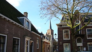
Oudshoorn is a former village in the Dutch province of South Holland. It was located on the Oude Rijn, opposite the village of Alphen, with which it merged to form the city of Alphen aan den Rijn.

Rijnsaterwoude is a village in the Dutch province of South Holland. It is located about 6 km north of the town of Alphen aan den Rijn, in the municipality of Kaag en Braassem.
Zuidwijk is a former municipality in the Dutch province of South Holland. It was located southeast of the center of Boskoop.
The Gouwestreek is the area around Gouda in the province of South Holland in the Netherlands. "Gouwe" refers to the river Gouwe, which runs through Gouda. The Gouwestreek is not an official or precisely defined region, but generally speaking it includes the following municipalities:
Bent is a hamlet in the Dutch province of South Holland. It is located in the municipality of Alphen aan den Rijn, about 2 km northwest of the village Hazerswoude-Dorp.
On 9 April 2011, six people were killed by a gunman who entered the Ridderhof mall in Alphen aan den Rijn, Netherlands, a town approximately 33 kilometres (21 mi) south-west of Amsterdam. Using a rifle, 24-year-old Tristan van der Vlis shot several people and then killed himself, reportedly with a different firearm. There were seven deaths, including the killer, and 17 wounded, making it the deadliest attack in the Netherlands since the 2009 attack on the Dutch royal family.
Albaniana was the name the ancient Romans gave a settlement on the southern banks of Rhine river, some 40 kilometers from its mouth in the North Sea, known as Alfen and modern-day Alphen aan den Rijn, Netherlands. They did build a military fort there, as part of a range strategically built encampments, to protect and guard the river, frontier (limes) of the Roman empire and main transport route of goods and troops. The historical map Tabula Peutingeriana situates the settlement in between Matilo (Leiden) and Praetorium Agrippinae (Valkenburg) downstream and Nigrum Pullum (Zwammerdam) and Fectio (Vechten) upstream. The village was mentioned in Antoninus' register of roads Itinerarium Antonini from the 3rd century. The fortress must have been surrounded by a wall of ground and wooden poles, with gates and watch towers.

Waddinxveen Triangel railway station is a railway station in Waddinxveen, South Holland, Netherlands that opened on 12 February 2018. It is situated on the Gouda–Alphen aan den Rijn railway, which connects Gouda and Alphen aan den Rijn, 1,5 kilometre south of Waddinxveen railway station. Trains running on the line are R-net Stadler FLIRTs.
References
- ↑ Ad van der Meer and Onno Boonstra, Repertorium van Nederlandse gemeenten , KNAW, 2011.
52°07′42″N4°39′13″E / 52.1283°N 4.6536°E
| | This South Holland location article is a stub. You can help Wikipedia by expanding it. |