
The Canterbury Plains are an area in New Zealand centred in the Mid Canterbury, to the south of the city of Christchurch in the Canterbury region. Their northern extremes are at the foot of the Hundalee Hills in the Hurunui District, and in the south they merge into the plains of North Otago beyond the Waitaki River. The smaller Amuri Plain forms a northern extension of the plains.

The Waimakariri River is one of the largest rivers in Canterbury, on the eastern coast of New Zealand's South Island. It flows for 151 kilometres (94 mi) in a generally southeastward direction from the Southern Alps across the Canterbury Plains to the Pacific Ocean.
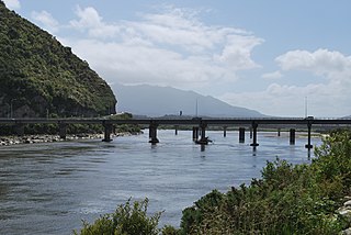
The Grey River / Māwheranui is located in the northwest of the South Island of New Zealand. It rises 12 kilometres southwest of the Lewis Pass in Lake Christabel, one of numerous small lakes on the western side of the Southern Alps, and runs westward for 120 kilometres before draining into the Tasman Sea at Greymouth. Thomas Brunner, who explored the area in the late 1840s, named the river in honour of Sir George Grey, who first served as Governor of New Zealand from 1845 to 1854. The Ngāi Tahu Claims Settlement Act 1998 changed the official name of the river to Grey River / Māwheranui in 1998. The Māori name for the river system and surrounding area is Māwhera, with Māwheranui being distinguished from the northern branch Little Grey River / Māwheraiti.
Kahurangi Point is a headland on the West Coast of New Zealand's South Island, overlooking the Tasman Sea. It is located in Kahurangi National Park between Karamea and Farewell Spit.

The Buller Gorge is a gorge located in the northwest of the South Island of New Zealand. The Buller River flows through the deep canyon between Murchison and Westport. Land Information New Zealand lists two sections for the gorge, Upper Buller Gorge and Lower Buller Gorge. State Highway 6 runs alongside, but considerably above, the river through the gorge. The Stillwater - Westport Line railway also runs through the gorge.

The Rakaia River is in the Canterbury Plains in New Zealand's South Island. The Rakaia River is one of the largest braided rivers in New Zealand. The Rakaia River has a mean flow of 203 cubic metres per second (7,200 cu ft/s) and a mean annual seven-day low flow of 87 m3/s (3,100 cu ft/s). In the 1850s, European settlers named it the Cholmondeley River, but this name lapsed into disuse. The name Rakaia comes from Māori "Ō Rakaia", meaning the place where people were arranged by ranks
The Keltie Glacier is a large Antarctic glacier, 30 nautical miles (56 km) long, draining from Pain Névé southwest around the southern extremity of the Commonwealth Range, and then northwest to enter Beardmore Glacier at Ranfurly Point. It was discovered by the British Antarctic Expedition, 1907–09, under Ernest Shackleton, who named it for Sir John Scott Keltie, Secretary of the Royal Geographical Society, 1892–1915.
The Anaweka River is small river in a remote area of the Tasman District of New Zealand. Its source is on the slopes of Mount White in the Wakamarama Range. The river flows to the Tasman Sea, the mouth being about 3 kilometres (2 mi) south of the southern end of the road from Farewell Spit and Collingwood.

The Anne River is a small river in Canterbury, New Zealand. It rises near the Anne Saddle and flows east then north for approximately 6 kilometres (4 mi) until it meets the Henry River, itself a tributary of the Waiau Uwha River. The St James Walkway, a popular tramping track, follows the Anne River for its entire length, and the Anne Huts are located near the river's mouth.

The Doubtful River is a river in the Canterbury region of New Zealand. It rises near Mount Barron and flows south then south-east through Lake Sumner Forest Park, reaching the Boyle River 40 kilometres (25 mi) west of Hanmer Springs. The Doubtful Range lies to the south. The Doubtless River and Devilskin Stream are tributaries entering from the north.
The Grantham River is a river in the Canterbury region of New Zealand. It arises in the Hanmer Range near Mount Miromiro, in the Hanmer Forest Park, and flows south-east into the Waiau Uwha River, which has its mouth on the Pacific Ocean.
The Hororata River is a river of Canterbury, in the South Island of New Zealand. A tributary of the Selwyn River, the Hororata has its sources in rough hill country north of Windwhistle, and flows east through the township of Hororata before reaching the Selwyn 12 kilometres (7 mi) northwest of Dunsandel.
The Karetu River is a river of New Zealand's eastern South Island. It flows south from the slopes of Mount Karetu before its outflow into the Okuku River at the edge of the Canterbury Plains 40 kilometres (25 mi) northwest of Christchurch.
The Kiwi River is a river of New Zealand's South Island. One of the headwaters of the Hope River, it flows generally northwest from its source within Lake Sumner Forest Park, 4 kilometres (2.5 mi) north of Lake Sumner.

The Kokatahi River is a river of the West Coast Region of New Zealand's South Island. A major tributary of the Hokitika River, it flows northwest from its origins on the northern slopes of Mount Ambrose, reaching the Hokitika River 12 kilometres from the latter's mouth at Hokitika. The two rivers between them share one of the West Coast's larger floodplains.
The Little Hope River is a river of the northwest of New Zealand's South Island. It flows from the western flank of the Hope Saddle, meeting with the waters of the Hope River after seven kilometres at the settlement of Glenhope. State Highway 6 follows the valley of the Little Hope River immediately after crossing the saddle.
The Pahau River or Pahu River is a river of the north Canterbury region of New Zealand's South Island. It has its origins in the Tekoa Range, 25 kilometres (16 mi) northwest of Culverden, and flows initially north before turning south to flow down a long valley between two ridges. At the northern edge of the Canterbury Plains it turns southeast, flowing past the southern outskirts of Culverden to reach the Hurunui River 8 kilometres (5 mi) southeast of the town.
The Rahu River is a river in the Buller District of New Zealand's South Island. It rises in two branches within Victoria Forest Park. From the junction of these two branches, the Rahu flows initially southeast before turning north to flow into the Maruia River 5 kilometres (3.1 mi) north of Springs Junction. State Highway 7 follows the upper course of the Rahu to the northwest of Springs Junction, crossing the Rahu Saddle into the valley of the Inangahua River.
The Whakaikai River is a short river of the West Coast Region of New Zealand's South Island. It flows generally northwest to reach the Tasman Sea five kilometres to the northwest of the mouth of the Wanganui River.

Motupipi is a settlement in the Tasman District of New Zealand's upper South Island, located at the mouth of the Motupipi River east of Tākaka.