Related Research Articles

The Bahamas, officially the Commonwealth of The Bahamas, is an island country within the Lucayan Archipelago of the Atlantic Ocean. It contains 97% of the Lucayan Archipelago's land area and 88% of its population. The archipelagic country consists of more than 3,000 islands, cays, and islets in the Atlantic Ocean, and is located north of Cuba and northwest of the island of Hispaniola and the Turks and Caicos Islands, southeast of the U.S. state of Florida, and east of the Florida Keys. The capital is Nassau on the island of New Providence. The Royal Bahamas Defence Force describes The Bahamas' territory as encompassing 470,000 km2 (180,000 sq mi) of ocean space.

Kirtland's warbler, also known in Michigan by the common name jack pine bird, or the jack pine warbler, is a small songbird of the New World warbler family (Parulidae). Nearly extinct just 50 years ago, populations have recovered due to the conservation efforts of Phil Huber and the U.S. Forest Service. It requires large areas, greater than 160 acres, of dense young jack pine for its breeding habitat. This habitat was historically created by wildfire, but today is created through the harvest of mature jack pine, and planting of jack pine seedlings.

Andros Island is an archipelago within The Bahamas, the largest of the Bahamian Islands. Politically considered a single island, Andros in total has an area greater than all the other 700 Bahamian islands combined. The land area of Andros consists of hundreds of small islets and cays connected by mangrove estuaries and tidal swamplands, together with three major islands: North Andros, Mangrove Cay, and South Andros. The three main islands are separated by bights, estuaries that trifurcate the island from east to west. It is 167 kilometres (104 mi) long by 64 km (40 mi) wide at the widest point.

The Apalachicola River is a river, approximately 160 miles (260 km) long, in the state of Florida. The river's large watershed, known as the Apalachicola, Chattahoochee and Flint (ACF) River Basin, drains an area of approximately 19,500 square miles (50,500 km2) into the Gulf of Mexico. The distance to its farthest head waters in northeast Georgia is approximately 500 miles (800 km). Its name comes from Apalachicola Province, an association of Native American towns located on what is now the Chattahoochee River. The Spanish included what is now called the Chattahoochee River as part of one river, calling all of it from its origins in the southern Appalachian foothills down to the Gulf of Mexico the Apalachicola.

White Pines Forest State Park, more commonly referred to as White Pines State Park, is an Illinois state park in Ogle County, Illinois. It is located near the communities of Polo, Mount Morris and Oregon. The 385-acre (156 ha) park contains the southernmost remaining stand of native white pine trees in the state of Illinois, and that area, 43 acres (17 ha), was designated an Illinois Nature Preserve in 2001.
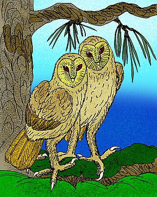
Tyto pollens is an extinct giant barn owl which lived in the Bahamas during the last Ice Age.
Since declaring independence in 1981, Belize has enacted many environmental protection laws aimed at the preservation of the country's natural and cultural heritage, as well as its wealth of natural resources. These acts have established a number of different types of protected areas, with each category having its own set of regulations dictating public access, resource extraction, land use and ownership.
The Golden Gate National Parks Conservancy is a nonprofit cooperating association that supports park stewardship and conservation in the Golden Gate National Recreation Area—the most visited national park in the U.S.

The Jamaican slider, also known as the Cat Island slider, is a species of fresh water turtle in the family Emydidae. It is found in the Bahamas and Jamaica. As it is not currently found on any of the other surrounding islands in the region, it is assumed that the Jamaican slider was introduced from one of these countries to the other. Even though the popular theory was that these turtles originated from Jamaica, current geological evidence may suggest that they were in the Bahamas long before the native Taíno first went to the Bahamian islands. There is also evidence from archeological sites on San Salvador that the Taíno ate these turtles and transplanted them around the West Indies.
The following outline is provided as an overview of and topical guide to The Bahamas:
The Bahamas National Trust is a non-profit organisation in the Bahamas that manages the country's 32 national parks. Its headquarters is located in New Providence in the Bay Street Business Centre, East Bay Street. Its office was formally located at The Retreat Gardens on Village Road. The Bahamas National Trust was created by an Act of Parliament in 1959, through the efforts of two groups of conservationists.

The following is an alphabetical list of topics related to the Commonwealth of The Bahamas.

The Bahamian dry forests are a tropical and subtropical dry broadleaf forest ecoregion in the Bahamas and the Turks and Caicos Islands, covering an area of 4,900 km2 (1,900 sq mi). They are found on much of the northern Bahamas, including Andros, Abaco, and Grand Bahama, where they are known as coppices. Dry forests are distributed evenly throughout the Turks and Caicos.

The Bahamian pineyards are a tropical and subtropical coniferous forest ecoregion in the Bahamas and the Turks and Caicos Islands.

Tropical hardwood hammocks are closed canopy forests, dominated by a diverse assemblage of evergreen and semi-deciduous tree and shrub species, mostly of West Indian origin. Tropical hardwood hammocks are found in South Florida or the Everglades, with large concentrations on the Miami Rock Ridge, in the Florida Keys, along the northern shores of Florida Bay, and in the Pinecrest region of the Big Cypress Swamp.
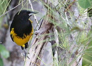
The Bahama oriole is a species of songbird in the New World blackbird family Icteridae. It is endemic to the Bahamas, and listed as endangered by the IUCN Red List.

Quicksand Pond is a pond in Little Compton, Rhode Island.
West Side National Park is a national park covering the western half of Andros, the Bahamas, and the surrounding waters. The park was established in 2002 and, after being expanded in 2012, has an area of 1,500,000 acres (6,070 km2), being one of the largest protected areas in the region. The park is regarded as a marine protected area, which includes tidal creeks and coastal mangrove forest, as well as an expansive coastal zone.
References
- ↑ "Central Andros National Park". Bahamas National Trust. Archived from the original on 19 October 2011.
- ↑ "ANCAT Andros Conservancy and Trust Bahamas". ANCAT. Archived from the original on 4 September 2011. Retrieved 4 September 2011.
- ↑ Todhunter, Andrew. "Bahamas Caves: Deep, Dark Secrets". National Geographic. Archived from the original on 24 July 2010. Retrieved 4 September 2011.
- ↑ "The Bahamas/Andros Island". The Nature Conservancy.
- ↑ "Andros Conservancy and Trust". Project AWARE.