Look up Angara in Wiktionary, the free dictionary.
The Angara is a major river in south-east Siberia, Russia, connecting Lake Baikal to the Yenisey river and thence the Arctic Ocean.
Contents
Angara may also refer to:
The Angara is a major river in south-east Siberia, Russia, connecting Lake Baikal to the Yenisey river and thence the Arctic Ocean.
Angara may also refer to:
The following places are all near the Angara River:

Russia is the largest country in the world, covering over 17,125,191 km2 (6,612,073 sq mi), and encompassing more than one-eighth of Earth's inhabited land area. Russia extends across eleven time zones, and has the most borders of any country in the world, with sixteen sovereign nations.

Lake Baikal is the deepest rift lake in the world. It is situated in southern Siberia, Russia between the federal subjects of Irkutsk Oblast to the northwest and the Republic of Buryatia to the southeast.

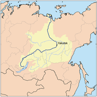
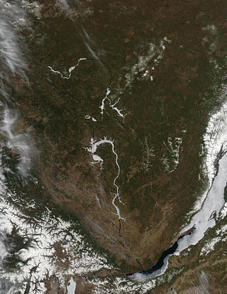
The Angara is a major river in Siberia, which traces a course through Russia's Irkutsk Oblast and Krasnoyarsk Krai. It drains out of Lake Baikal and is the headwater tributary of the Yenisey. It is 1,849 kilometres (1,149 mi) long, and has a drainage basin of 1,039,000 square kilometres (401,000 sq mi). It was formerly known as the Lower or Nizhnyaya Angara. Below its junction with the Ilim, it was formerly known as the Upper Tunguska and, with the names reversed, as the Lower Tunguska.

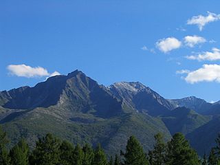
The Sayan Mountains are a mountain range in southern Siberia spanning southeastern Russia and northern Mongolia. Before the rapid expansion of the Tsardom of Russia, the mountain range served as the border between Mongolian and Russian cultures and cultural influences.

The Upper Angara is a river in Buryatia, Siberia to the northeast of Lake Baikal. the third longest river in the Baikal basin. It is 438 kilometres (272 mi) long, and has a drainage basin of 21,400 square kilometres (8,300 sq mi).
Baykal, or Lake Baikal, is a lake in southern Siberia, Russia.

The Lena is a river in the Russian Far East, and is the easternmost of the three great Siberian rivers that flow into the Arctic Ocean. The Lena is the eleventh-longest river in the world, and the longest river entirely within Russia, with a length of 4,294 km (2,668 mi) and a drainage basin of 2,490,000 km2 (960,000 sq mi). Permafrost underlies most of the catchment, 20% of which is continuous.

The Baikal Mountains or Baikal Range are a mountain range that rises steeply over the northwestern shore of Lake Baikal in southern Siberia, Russia. The highest peak in the range is 2,572 m high Mount Chersky, named after Russian explorer Ivan Chersky.
The Churo is a river in Buryatia, southern East Siberia, Russia. It is a tributary of the Upper Angara river of the Angara - Baikal basin. The river is 209 kilometres (130 mi) long, and has a drainage basin of 9,460 square kilometres (3,650 sq mi). There are no settlements by the river.
Kurbat Afanasyevich Ivanov was a Cossack explorer of Siberia. He was the first Russian to encounter Lake Baikal, and to create the first map of the Russian Far East. He also is credited with creation of the early map of Chukotka and Bering Strait, which was the first to show the yet undiscovered Wrangel Island, both Diomede Islands and Alaska.
The Northern Muya Range is a mountain range in Buryatia, Russia, part of the Stanovoy Highlands.

The Stanovoy Highlands or Stanovoy Uplands is a mountain range in the Transbaikal region of Siberia, Russia.

Pribaikalsky National Park covers the southwest coast of Lake Baikal in southeastern Siberia. The coastal strip includes the lake-facing slopes of the Primorsky Range to the west, as well as offshore islands such as Olkhon Island to the east. It is about 50 km southeast of the city of Irkutsk, Irkutsk Oblast. The park is managed with three other nature reserves, and is a major component of the UNESCO World Heritage Site "Lake Baikal". The Angara River, which is the outflow of Lake Baikal west into the Yenisei River basin, runs through the park. The park has very high levels of biodiversity and endemic species.

Baikalia is a vague geographical term referring to the region around Lake Baikal. It is less common than the concept of Transbaikalia, the area to the east of Lake Baikal. The term Baikalia is loosely defined and has no official definition.

The South Siberian Mountains are one of the largest mountain systems of the Russian Federation. The total area of the system of mountain ranges is more than 1.5 million km². The South Siberian Mountains are located in the Siberian and Far Eastern Federal Districts of Russia, as well as partly in Mongolia. The territory of the mountain system is one of the Great Russian Regions.

The Primorsky Range is a range of mountains in Southern Siberia, part of the South Siberian Mountains. Administratively the range belongs to the Irkutsk Oblast, Russian Federation. The settlement of Buguldeyka, Olkhonsky District, is located in the range area.
The Lena-Angara Plateau, is a plateau in Siberia. Administratively it is in the Irkutsk Oblast, Russian Federation. The plateau is named after the Lena and Angara rivers, of which it forms the watershed. Rivers on the plateau flow mostly in a south–north direction.
The Upper Angara Range is a mountain range in Buryatia and Irkutsk Oblast, Russia, part of the Stanovoy Highlands.
The Delyun-Uran Range is a mountain range in Irkutsk Oblast and Buryatia, Russia, part of the Stanovoy Highlands.

Lower Angara is a region of Russia. It is seen as a link between Northern Siberia and Southern Siberia. It corresponds to the lower regions of the Angara River