The Anglo-French Conference on Time-keeping at Sea was a conference held in London in June 1917.
The Anglo-French Conference on Time-keeping at Sea was a conference held in London in June 1917.
The Conference established the nautical date line and adopted an ideal form of the terrestrial time zone system for use at sea. It recommended that time changes required by changes of longitude be made in one-hour steps. This recommendation was adopted between 1920 and 1925 by all major fleets, including British, French and American. The rules applied to almost all naval ships and to many non-naval ships. Nevertheless, up to the Second World War, the old practice of keeping local apparent time prevailed on many independent merchant ships.
The nautical date line is implied but not explicitly drawn on time zone maps. It follows the 180° meridian except where it is interrupted by territorial waters adjacent to land, forming gaps: it is a pole-to-pole dashed line. Ships are required to adopt the standard time of a country when they are within its territorial waters, but must revert to international time zones (15° wide pole-to-pole gores) as soon as they leave territorial waters. The 15° gore that is offset from GMT or UT1 (not UTC) by twelve hours is bisected by the nautical date line into two 7.5° gores that differ from GMT by ±12 hours.
In reality nautical time zones are used only for radio communication etc. Internally on the ship, e.g. for work and meal hours, the ship may use a suitable time of its own choosing. This includes fixed installations such as oil rigs. For example, the Norwegian Ekofisk oil rigs are located in international water at longitude 3°E but use Norwegian time.

Greenwich Mean Time (GMT) is the mean solar time at the Royal Observatory in Greenwich, London, counted from midnight. At different times in the past, it has been calculated in different ways, including being calculated from noon; as a consequence, it cannot be used to specify a particular time unless a context is given. The term 'GMT' is also used as one of the names for the time zone UTC+00:00 and, in UK law, is the basis for civil time in the United Kingdom.
A nautical mile is a unit of length used in air, marine, and space navigation, and for the definition of territorial waters. Historically, it was defined as the meridian arc length corresponding to one minute of latitude. Today the international nautical mile is defined as exactly 1,852 metres. The derived unit of speed is the knot, one nautical mile per hour.

Navigation is a field of study that focuses on the process of monitoring and controlling the movement of a craft or vehicle from one place to another. The field of navigation includes four general categories: land navigation, marine navigation, aeronautic navigation, and space navigation.

A time zone is an area which observes a uniform standard time for legal, commercial and social purposes. Time zones tend to follow the boundaries between countries and their subdivisions instead of strictly following longitude, because it is convenient for areas in frequent communication to keep the same time.
The United Nations Convention on the Law of the Sea (UNCLOS), also called the Law of the Sea Convention or the Law of the Sea Treaty, is an international agreement that establishes a legal framework for all marine and maritime activities. As of June 2016, 167 countries and the European Union are parties.
Universal Time is a time standard based on Earth's rotation. While originally it was mean solar time at 0° longitude, precise measurements of the Sun are difficult. Therefore, UT1 is computed from a measure of the Earth's angle with respect to the International Celestial Reference Frame (ICRF), called the Earth Rotation Angle. UT1 is the same everywhere on Earth. UT1 is required to follow the relationship

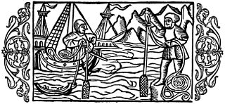
Celestial navigation, also known as astronavigation, is the practice of position fixing using stars and other celestial bodies that enables a navigator to accurately determine their actual current physical position in space or on the surface of the Earth without relying solely on estimated positional calculations, commonly known as "dead reckoning". Celestial navigation is performed without using satellite navigation or other similar modern electronic or digital positioning means.
The International Meridian Conference was a conference held in October 1884 in Washington, D.C., in the United States, to determine a prime meridian for international use. The conference was held at the request of U.S. President Chester A. Arthur. The subject to discuss was the choice of "a meridian to be employed as a common zero of longitude and standard of time reckoning throughout the world". It resulted in the recommendation of the Greenwich Meridian as the international standard for zero degrees longitude.

The International Date Line (IDL) is an internationally accepted demarcation of the surface of Earth, running between the South and North Poles and serving as the boundary between one calendar day and the next. It passes through the Pacific Ocean, roughly following the 180.0° line of longitude and deviating to pass around some territories and island groups. Crossing the date line eastbound decreases the date by one day, while crossing the date line westbound increases the date.

Territorial waters are informally an area of water where a sovereign state has jurisdiction, including internal waters, the territorial sea, the contiguous zone, the exclusive economic zone, and potentially the extended continental shelf. In a narrower sense, the term is often used as a synonym for the territorial sea.
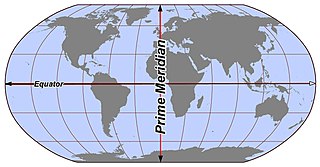
In geography and geodesy, a meridian is the locus connecting points of equal longitude, which is the angle east or west of a given prime meridian. In other words, it is a line of longitude. The position of a point along the meridian is given by that longitude and its latitude, measured in angular degrees north or south of the Equator. On a Mercator projection or on a Gall-Peters projection, each meridian is perpendicular to all circles of latitude. A meridian is half of a great circle on Earth's surface. The length of a meridian on a modern ellipsoid model of Earth has been estimated as 20,003.93 km (12,429.87 mi).

Replenishment at sea (RAS) or underway replenishment (UNREP) is a method of transferring fuel, munitions, and stores from one ship to another while under way. First developed in the early 20th century, it was used extensively by the United States Navy as a logistics support technique in the Pacific theatre of World War II, permitting U.S. carrier task forces to remain at sea indefinitely.
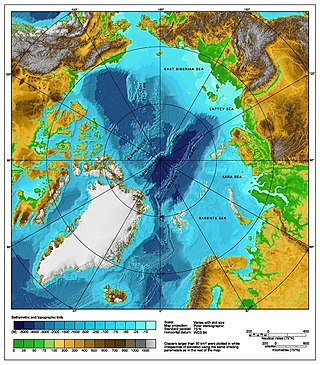
The Arctic consists of land, internal waters, territorial seas, exclusive economic zones (EEZs) and international waters above the Arctic Circle. All land, internal waters, territorial seas and EEZs in the Arctic are under the jurisdiction of one of the eight Arctic coastal states: Canada, Denmark, Finland, Iceland, Norway, Russia, Sweden and the United States. International law regulates this area as with other portions of Earth.
Nautical time is a maritime time standard established in the 1920s to allow ships on high seas to coordinate their local time with other ships, consistent with a long nautical tradition of accurate celestial navigation. Nautical time divides the globe into 24 nautical time zones with hourly clock offsets, spaced at 15 degrees by longitudinal coordinate, with no political deviation.

Longitude: The True Story of a Lone Genius Who Solved the Greatest Scientific Problem of His Time is a best-selling book by Dava Sobel about John Harrison, an 18th-century clockmaker who created the first clock (chronometer) sufficiently accurate to be used to determine longitude at sea—an important development in navigation. The book was made into a television series entitled Longitude. In 1998, The Illustrated Longitude was published, supplementing the earlier text with 180 images of characters, events, instruments, maps and publications.
Depth sounding, often simply called sounding, is measuring the depth of a body of water. Data taken from soundings are used in bathymetry to make maps of the floor of a body of water, such as the seabed topography.

Myanmar Standard Time, formerly Burma Standard Time (BST), is the standard time in Myanmar, 6.5 hours ahead of UTC. MMT is calculated on the basis of 97°30′E longitude. MMT is used all year round, as Myanmar does not observe daylight saving time.

The Arctic policy of Russia is the domestic and foreign policy of the Russian Federation with respect to the Russian region of the Arctic. The Russian region of the Arctic is defined in the "Russian Arctic Policy" as all Russian possessions located north of the Arctic Circle. Approximately one-fifth of Russia's landmass is north of the Arctic Circle. Russia is one of five littoral states bordering the Arctic Ocean. As of 2010, out of 4 million inhabitants of the Arctic, roughly 2 million lived in arctic Russia, making it the largest arctic country by population. However, in recent years Russia's Arctic population has been declining.

Oil Pollution Act of 1961, 33 U.S.C. Chapter 20 §§ 1001-1011, established judicial definitions and coastal prohibitions for the United States maritime industry. The Act invoked the accords of the International Convention for the Prevention of the Pollution of the Sea by Oil, 1954. The international agreement provided provisions to control the discharge of fossil fuel pollutants from nautical vessels on the high seas.

Vietnam claims an exclusive economic zone (EEZ) of 1,395,096 km2 (538,650 sq mi) with 200 nautical miles from its shores.