
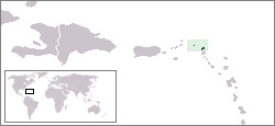
Anguilla is a British overseas territory in the Caribbean. It is one of the most northerly of the Leeward Islands in the Lesser Antilles, lying east of Puerto Rico and the Virgin Islands and directly north of Saint Martin. The territory consists of the main island of Anguilla, approximately 16 miles long by 3 miles (5 km) wide at its widest point, together with a number of much smaller islands and cays with no permanent population. The territory's capital is The Valley. The total land area of the territory is 35 square miles (91 km2), with a population of approximately 18,090.

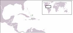
The Turks and Caicos Islands are a British Overseas Territory consisting of the larger Caicos Islands and smaller Turks Islands, two groups of tropical islands in the Lucayan Archipelago of the Atlantic Ocean and northern West Indies. They are known primarily for tourism and as an offshore financial centre. The resident population was 31,458 as of 2012 of whom 23,769 live on Providenciales in the Caicos Islands; July 2020 estimates put the population at 55,926. It is the third largest of the British overseas territories by population.

Anguilla is an island in the Leeward Islands, which lies between the Caribbean Sea in the west and the open Atlantic Ocean in the east. It is a long, flat, dry/wet, scrub-covered coral island, south and east of Puerto Rico and north of the Windward chain. It is separated from the British Virgin Islands by the Anegada Passage. The island has no significant elevations with its terrain consisting entirely of beaches, dunes, and low limestone bluffs.
The following is an alphabetical list of topics related to the British Overseas Territory of Anguilla.

A cay, also spelled caye or key, is a small, low-elevation, sandy island on the surface of a coral reef. Cays occur in tropical environments throughout the Pacific, Atlantic and Indian Oceans.
The West Indies Associated States was the collective name for a number of islands in the Eastern Caribbean whose status changed from being British colonies to states in free association with the United Kingdom in 1967. These states were Antigua, Dominica, Grenada, Saint Christopher–Nevis–Anguilla, Saint Lucia, and Saint Vincent.

Cay Sal Bank is the third largest and the westernmost of the Bahama Banks. It is located between 23º27'N - 24º10'N and 079º25'W – 080º35'W. In a geographical sense, it is separate from the Bahamas proper as it is much closer to Cuba than to the closest Bahamanian island. It is separated by Santaren Channel from the Great Bahama Bank, the western rim of which is 50 km (31 mi) to the east. The Straits of Florida separate it from the United States mainland and the Florida Keys.

The Caribbean elaenia is a species of bird in the family Tyrannidae found in the West Indies and parts of Central America. Its natural habitats are tropical and subtropical dry broadleaf forest, subtropical or tropical moist lowland forest, and heavily degraded former forest.
The following outline is provided as an overview of and topical guide to Anguilla:

The following outline is provided as an overview of and topical guide to The Bahamas:

The following is an alphabetical list of articles related to the territory of the United States Virgin Islands.

The following is an alphabetical list of topics related to the British Overseas Territory of the Cayman Islands.
The following is an alphabetical list of topics related to the British Overseas Territory of the Turks and Caicos Islands.

The following is an alphabetical list of topics related to the Commonwealth of The Bahamas.
Anguilla is a British overseas territory in the Caribbean, one of the most northerly of the Leeward Islands in the Lesser Antilles. It consists of the main island of Anguilla itself, together with a number of much smaller islands and cays with no permanent population.

Dog Island is an uninhabitated small island of 207 ha located approximately 13 km (8.1 mi) to the north-west of Anguilla. It is low and rocky, with three small cays off the west and north coasts. The coastline is characterised by low cliffs alternating with sandy beaches. Large ponds lie inside two of the beaches. Dog Island lies west of the Prickley Pear Cays.

The Prickly Pear Cays, sometimes spelt as Prickley Pear Cays, are a small pair of uninhabited islands about six miles from Road Bay, Anguilla, in the Leeward Islands of the Caribbean. They are divided by a narrow boat channel between Prickly Pear East and Prickly Pear West. Prickly Pear Cays were classified as 'wildlands' by the "Eastern Caribbean Natural Area Management Programme" (ECNAMP). In addition, Prickly Pear Cays are one of six marine protected areas of Anguilla.
This page is based on this
Wikipedia article Text is available under the
CC BY-SA 4.0 license; additional terms may apply.
Images, videos and audio are available under their respective licenses.