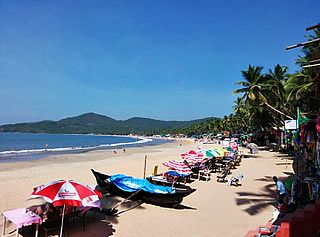
Karwar is a city in Uttara Kannada district in the Indian state of Karnataka and the administrative centre of Uttara Kannada district. Karwar lies on the west coast of Southern India at the mouth of the Kali river. Its geography creates a natural harbour with protection against monsoon weather. Being a port town, Karwar is a centre for agriculture, some manufacturing and tourism. It is situated between Sahyadri ever green forest in east, blue Arabian Sea to the west, towards south ends with harbour and North the Kali river. It is one of the green cities of India with eco tourism. Hills has created a natural harbour with protection against wind and sea tides naturally. Being a port town, Karwar is a centre for fish business, agriculture, known for manufacturing of golden ornaments in Karwarian style and under-developed tourism. It has a population of about 77139. Karwar was part of the Bombay Presidency until 1956. Karwar is known as Kashmir of Karnataka by Rabindranath Tagore, Kuvempu and D. R. Bendre. Tagore wrote his first Drama on Karwar beach. Notable people include Rama Raghoba Rane, Former Chief Justice of India Justice D. G. Palekar and spiritual guru Shri Padmanabh Maharaj.

Dudhsagar Falls is a four-tiered waterfall located on the Mandovi River in the Indian state of Goa. It is 60 km from Panaji by road and is located on the Madgaon-Belagavi rail route about 46 km east of Madgaon and 80 km south of Belagavi. Dudhsagar Falls is amongst India's tallest waterfalls with a height of 310 m (1017 feet) and an average width of 30 metres (100 feet).

Mollem is a small village in Goa, South India on National Highway 4 near the border with Karnataka in the foothills of the Sahyadri Mountain range at the beginning of Anmod Ghat. It comes under the Sanguem block. It is the primary entry point for Bhagwan Mahaveer Sanctuary and Mollem National Park.

Castle Rock is a village in the Uttara Kannada district of the Indian state of Karnataka. The village is located in the Western Ghats on the state's border with Goa - at an elevation of 621 m (2,040 ft).

The Indian State of Karnataka is located 11°30' North and 18°30' North latitudes and 74° East and 78°30' East longitude. It is situated on a tableland where the Western and Eastern Ghat ranges converge into the complex, in the western part of the Deccan Peninsular region of India. The State is bounded by Maharashtra and Goa States in the north and northwest; by the Arabian Sea in the west; by Kerala and Tamil Nadu States in the south and by the States of Andhra Pradesh and Telangana in the east. Karnataka extends to about 750 km from north to south and about 400 km from east to west.

Dodamarg taluka is a taluka in Sindhudurg district in the Indian state of Maharashtra.
Chandgad is a small city and tehsil headquarters in Gadhinglaj, which is a subdivision of Kolhapur district that is in the Indian state of Maharashtra. Jagrut Devastan Sri Ravalnath temple is located here.

Bhagwan Mahaveer Sanctuary and Mollem National Park is a 240 square kilometres (93 sq mi) protected area located in the Western Ghats of South India, in Sanguem taluk, Goa State, along the eastern border with Karnataka. The area is situated near the town of Molem, 57 kilometres (35 mi) east of Panaji, the state capital of Goa. National Highway 4A divides it into two parts and the Mormugao - Londa railway line passes through the area. It is located between 15°15"30' to 15°29"30' N and 74°10"15' to 74°20"15' E. It contains several important temples dating to the Kadambas of Goa, and home to waterfalls, such as Dudhsagar Falls and Tambdi Falls. The parkland is also home to a community of nomadic buffalo herders known as the Dhangar.

Mahadeva Temple, Tambdi Surla is a 12th-century Shaivite temple of the Lord Mahadeva and an active place of Hindu worship. It is the only structural temple of the Kadamba period to survive the destructive violence of religious intolerance during Muslim and Portuguese occupations of Goan territory.
Kamadolli is a village in the southern state of Karnataka, India. It is located in the Kundgol taluk of Dharwad district in Karnataka. It is located about 30 km from the city of Hubli and about 200 km from the city of Panjim in Goa.
Ajgaon is a village in the southern state of Karnataka, India. It is located in the Haliyal taluk of Uttara Kannada district in Karnataka.
Bhimgad Wildlife Sanctuary is a protected area in the Western Ghats, in Khanapur Taluk of Belgaum District near Jamboti Village, Karnataka state, India. This 19,042.58 ha (73.5238 sq mi) of Tropical and subtropical moist broadleaf forests forest area was long awaiting to be a wild life sanctuary and finally declared in December 2011.
Amagaon is a village in Belgaum district bordered by Goa in west Uttara Kannada in south near Bhimgad Wild Life Sanctuary in the southern state of Karnataka, India. Amagaon nestles in the dense forests of the Western Ghats in and is known for its heavy rainfall. It is known to get over 10,000 mm annual rainfall occasionally and the average annual rainfall is around 9,000 mm. It is also called as Cherrapunji of South India
Chorla is a village in Belgaum district in the state of Karnataka. It is situated on border of Goa and Maharashtra.
Kanakumbi is a village in Belgaum district in Karnataka, India.. A beautiful village situated on boarder of satteri taluka Goa. Near cities are mapusa 65km. Punaji 71km. Belgaum city 45km. 101%konkani speaking people village. And people use village officially language is marathi. Karnataka and maharashtra boarder disputes on thise village but kanakumbi people not happy to accept or merge in maharashtra. But linguistic diversity kanakumbi village and their neibhar Villages injusticed by central govt. All people village belong hindu 96kuli Maratha community.village situated on MH Goa Ka boarder.
Mudgeri is a village in Karwar Taluka, Uttara Kannada district, Karnataka, India. It is close to the historic fort of Sadashivgad located on Kali river. Konkani is spoken as a local language.
National Highway 66, commonly referred to as NH 66, is a busy National Highway that runs roughly north–south along the western coast of India, parallel to the Western Ghats. It connects Panvel to Cape Comorin, passing through the states of Maharashtra, Goa, Karnataka, Kerala and Tamil Nadu.

National Highway 748 is a National Highway in India that starts from Belgaum in Karnataka and ends at Panaji in North Goa district. The highway is 153 km (95 mi) long, of which 82 km (51 mi) is in Karnataka and 71 km (44 mi) is in Goa. It is a spur road of National Highway 48.
National Highway 748AA, commonly referred to as NH 748AA is a national highway in India. It is a spur road of National Highway 48. NH-748AA traverses the states of Karnataka and Goa in India.