
Warwick Parish is one of the nine parishes of Bermuda. It is named after Robert Rich, 2nd Earl of Warwick (1587-1658).
Paget Parish is one of the nine parishes of Bermuda. It is named for William Paget, 4th Baron Paget de Beaudesert (1572–1629).

Devonshire Parish is one of the nine parishes of Bermuda. Originally named Cavendish Tribe and later Devonshire Tribe, for William Cavendish, 1st Earl of Devonshire (1552–1626). Devonshire Redoubt, on Castle Island, one of the Castle Harbour fortifications of St. George's Parish, was also named after him.

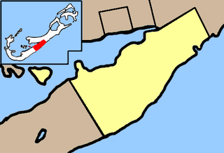
Hamilton Parish is one of the nine parishes of Bermuda. It was renamed for Scottish aristocrat James Hamilton, 2nd Marquess of Hamilton (1589–1625) when he purchased the shares originally held in the Virginia Company by Lucy Russell, Countess of Bedford.
St. George's Parish is one of the nine parishes of Bermuda. It is named after the founder of the Bermuda colony, Admiral Sir George Somers.

Horseshoe Bay is a well-known beach in Bermuda. As a tourist spot, it lies on the main island's south coast, in the parish of Southampton. It is one of two beaches of the same name in Bermuda, with the other located at Tucker's Island: since the 1940s part of a peninsula that housed the former US Naval Operating Base, and is now called Morgan's Point.

Hamilton Harbour is a natural harbour in Bermuda which serves as the port for the capital, the City of Hamilton. It is an arm of the Great Sound, and forms a tapering wedge shape of water between Paget Parish and the peninsula which forms Pembroke Parish, and upon which the capital sits.
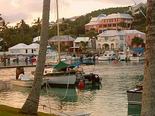
Flatts Village is a small settlement in Bermuda, lying on the southern bank of Flatt's Inlet in Hamilton Parish, almost exactly between the territory's two incorporated municipalities, Hamilton and St. George's.
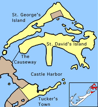
The Causeway is a narrow strip of reclaimed land and bridges in the north of Bermuda linking Hamilton Parish on the mainland in the southwest and Bermuda International Airport on St. David's Island in St. George's Parish in the northeast, which are otherwise divided by Castle Harbour.
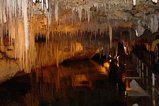
Crystal Cave is a cave in the British overseas territory of Bermuda. It is located in Hamilton Parish, close to Castle Harbour. The cave is approximately 500 m long, and 62 m deep. The lower 19–20 m of the cave are below water level. The cave formed at a time when the sea level was lower; as the sea level rose, many cave formations which formed above water became submerged.

Castle Harbour is a large natural harbour in Bermuda. It is located between the northeastern end of the main island and St. David's Island. Originally called Southampton Port, it was renamed as a result of its heavy fortification in the early decades of the Seventeenth century.
Cooper's Island is part of the chain which makes up Bermuda. It is located in St. George's Parish, in the northeast of the territory.
St. David's Island is one of the main islands of the British Overseas Territory of Bermuda. It is located in the far north of the territory, one of the two similarly sized islands that make up the majority of St. George's Parish.

Tobacco Bay is located in the far north of Bermuda. It lies on the Atlantic Ocean coast, close to the town of St. George's and to the historic Fort St. Catherine. One of Bermuda's national parks, it is a popular public beach. Snorkeling is a popular activity, as the bay has impressive underwater coral reefs, which explains its popularity with those who snorkel.
Church Bay is a bay with an accompanying beach in Southampton Parish, Bermuda. It serves as a popular snorkelling destination for locals.
Montana was a paddle steamer that was wrecked off the north coast of Bermuda on 30 December 1863.

The Bermuda Railway was a 21.7-mile (34.9 km) common carrier line that operated in Bermuda for a brief period. In its 17 years of existence, the railway provided frequent passenger and freight service over its length spanning most of the archipelago from St. George's in the east to Somerset, Sandys Parish, in the west.

The following outline is provided as an overview of and topical guide to Bermuda:

The Cathedral of the Most Holy Trinity is an Anglican cathedral located on Church Street in the City of Hamilton, in Pembroke Parish, in the British Overseas Territory of Bermuda.

The Berkeley Institute is a public senior high school in Pembroke Parish, Bermuda. As of 2016, it had about 500 students.
