
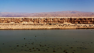
The Dead Sea, also known by other names, is a landlocked salt lake bordered by Jordan to the east and the Israeli-occupied West Bank and Israel to the west. It lies in the Jordan Rift Valley, and its main tributary is the Jordan River.

The Jordan River or River Jordan, also known as Nahr Al-Sharieat, is a 251-kilometre-long (156 mi) river in the Levant that flows roughly north to south through the freshwater Sea of Galilee and on to the salt water Dead Sea. The river passes by Jordan, Syria, Israel, and the Palestinian territories.

The Israel–Jordan peace treaty, sometimes referred to as the Wadi Araba Treaty, is an agreement that ended the state of war that has existed between the two countries since the 1948 Arab–Israeli War and established mutual diplomatic relations. In addition to establishing peace between the two countries, the treaty also settled land and water disputes, provided for broad cooperation in tourism and trade, and obligated both countries to prevent their territory being used as a staging ground for military strikes by a third country.

Lulav is a closed frond of the date palm tree. It is one of the Four Species used during the Jewish holiday of Sukkot. The other Species are the hadass (myrtle), aravah (willow), and etrog (citron). When bound together, the lulav, hadass, and aravah are commonly referred to as "the lulav".

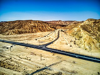
The Arabah/Araba or Aravah/Arava is a loosely defined geographic area in the Negev Desert, south of the Dead Sea basin, which forms part of the border between Israel to the west and Jordan to the east.

Brook of Egypt is the name used in some English translations of the Bible for the Hebrew נַחַל מִצְרַיִם, naḥal mizraim, a river (bed) forming the southernmost border of the Land of Israel. A number of scholars in the past identified it with Wadi el-Arish, an epiphemeral river flowing into the Mediterranean sea near the Egyptian city of Arish, while other scholars, including Israeli archaeologist Nadav Na'aman and the Italian Mario Liverani believe that the Besor stream, just to the south of Gaza, is the "Brook of Egypt" referenced in the Bible. A related phrase is nahar mizraim, used in Genesis 15:18.

The four species are four plants—the etrog, lulav, hadass, and aravah—mentioned in the Torah as being relevant to the Jewish holiday of Sukkot. Observant Jews tie together three types of branches and one type of fruit and wave them in a special ceremony each day of the Sukkot holiday, excluding Shabbat. According to Rabbinic Judaism, the waving of the four plants is a mitzvah prescribed by the Torah, and it contains symbolic allusions to a Jew's service of God.

The Red Sea–Dead Sea Conveyance (RSDSC), sometimes called the Two Seas Canal, was a planned pipeline to run from the coastal city of Aqaba by the Red Sea to the Lisan area in the Dead Sea. Its abandonment was reported in June 2021.

Ketura is a kibbutz in southern Israel. Located north of Eilat in the Aravah Valley, it falls under the jurisdiction of Hevel Eilot Regional Council. In 2022 it had a population of 509.
Highway 90 is the longest Israeli road, at about 480 kilometres (300 mi), and stretches from Metula and the northern border with Lebanon, along the western side of the Sea of Galilee, through the Jordan Valley, along the Dead Sea's western bank, through the Arava Valley, and until Eilat and the southern border with Egypt on the Red Sea. The central section of the road traverses the Israeli-occupied West Bank. While it passes near the city of Jericho, it runs through Area C and does not enter areas controlled by the Palestinian Authority.

The Arava Institute for Environmental Studies is an academic studies and research institute located in Kibbutz Ketura on the Israeli side of the Arava Valley. Following the understanding that "nature knows no borders", the Arava Institute's mission is to advance cross-border environmental cooperation in the face of political conflict.

Kalya is an Israeli settlement organized as a kibbutz in the West Bank. It was originally established in 1929 but was occupied and destroyed by the Jordanians in 1948; it was later rebuilt in 1968 after the Six-Day War. Located on the northern shore of the Dead Sea, 360 meters below sea level, it falls under the jurisdiction of Megilot Regional Council. In 2022 it had a population of 490.

The Jordan Valley forms part of the larger Jordan Rift Valley. Unlike most other river valleys, the term "Jordan Valley" often applies just to the lower course of the Jordan River, from the spot where it exits the Sea of Galilee in the north, to the end of its course where it flows into the Dead Sea in the south. In a wider sense, the term may also cover the Dead Sea basin and the Arabah valley, which is the rift valley segment beyond the Dead Sea and ending at Aqaba/Eilat, 155 km (96 mi) farther south.
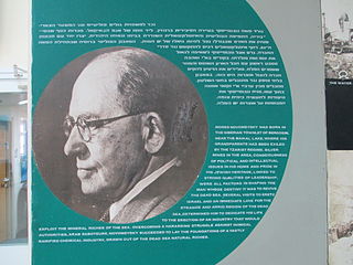
Moshe Novomeysky was an Israeli businessman and mining engineer. He was an early developer of the Palestine Potash Company, precursor to the Dead Sea Works.
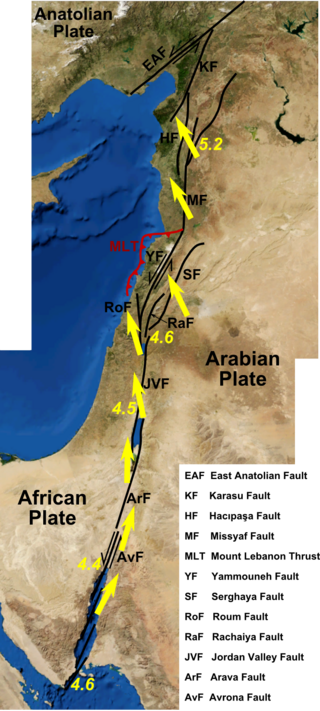
The Dead Sea Transform (DST) fault system, also sometimes referred to as the Dead Sea Rift, is a series of faults that run for about 1,000 km from the Maras Triple Junction to the northern end of the Red Sea Rift. The fault system forms the transform boundary between the African Plate to the west and the Arabian Plate to the east. It is a zone of left lateral (sinistral) displacement, signifying the relative motions of the two plates. Both plates are moving in a general north-northeast direction, but the Arabian Plate is moving faster, resulting in the observed left lateral motions along the fault of approximately 107 km at its southern end. A component of extension is also present in the southern part of the transform, which has contributed to a series of depressions, or pull-apart basins, forming the Gulf of Aqaba, Dead Sea, Sea of Galilee, and Hula basins. A component of shortening affects the Lebanon restraining bend, leading to uplift on both sides of the Beqaa valley. There is local transtension in the northernmost part of the fault system, forming the Ghab pull-apart basin. The fault system runs roughly along the political border of Israel, Jordan, and Lebanon.
The Valley of Peace initiative is an effort to promote economic cooperation between Israel, Jordan, and Palestine based around efforts and joint projects in the Arava/Arabah Valley, along which runs the southern portion of the Israel - Jordan border. It received the personal attention and support of Shimon Peres, President of Israel. The initiative involved ongoing joint efforts by regional leaders to launch joint new industrial and economic projects, which will create new local businesses and job growth, and promote ongoing cooperation.
Two major earthquakes occurred in the Near East on 18 March and 29 May, AD 1068. The two earthquakes are often amalgamated by contemporary sources. The first earthquake had its epicentre somewhere in the northwestern part of the Arabian Peninsula around Tabuk, while the second was most damaging in the city of Ramla in Palestine, some 500 km to the northwest.
The Arava Stream is an intermittent stream that flows from the approximate mid-point of the Arava desert in Israel's Southern District northward. It is 89 km long, and in many parts, serves as the actual border between Israel and Jordan. The stream originates on the crest of the Notza Ridge, which forms the watershed divide between the Dead Sea and the Red Sea, and from which all streams in the Arava desert flow either north to the Dead Sea or south to the Red Sea. The stream's prominent tributaries include: Nahal Paran, Nahal Barak, Nahal Tzin, Nahal Tzafit, and Nahal Nekorot. In addition to Israel and Jordan, parts of its drainage basin are in the Sinai Peninsula, Egypt.