Related Research Articles

A ship burial or boat grave is a burial in which a ship or boat is used either as the tomb for the dead and the grave goods, or as a part of the grave goods itself. If the ship is very small, it is called a boat grave. This style of burial was practiced by various seafaring cultures in Asia and Europe. Notable ship burial practices include those by the Germanic peoples, particularly by Viking Age Norsemen, as well as the pre-colonial ship burials described in the Boxer Codex in the Philippines.

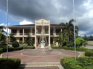
Pila, officially the Municipality of Pila, is a 3rd class municipality in the province of Laguna, Philippines. According to the 2020 census, it has a population of 54,613 people.
Catanauan, officially the Municipality of Catanauan, is a 1st class municipality in the province of Quezon, Philippines. According to the 2020 census, it has a population of 72,752 people.

Archaeology in Singapore is a niche but growing discipline. Although there is generally a lack of government support for archeological work, many artifacts have been unearthed at sites around the island, helping to give a clearer picture of Singapore's history, both concerning the early history of Singapore and its subsequent colonial settlement following the founding of modern Singapore, the former being particularly useful in revealing archaeological evidence reflecting references to settlements such as Temasek, Ban Zu, Long Ya Men and the Kingdom of Singapura in chronicles and records.
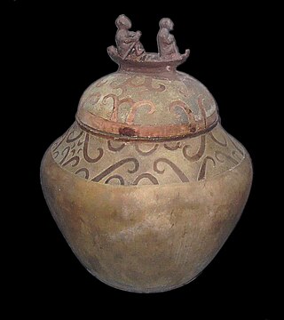
The Manunggul Jar is a secondary burial jar excavated from a Neolithic burial site in the Manunggul cave of the Tabon Caves at Lipuun Point in Palawan, Philippines. It dates from 890–710 B.C. and the two prominent figures at the top handle of its cover represent the journey of the soul to the afterlife.
Alfredo E. Evangelista was a Filipino archeologist and former director of the Anthropology division of the National Museum of the Philippines.

Santa Rita is a Maya ruin and an archaeological reserve on the outskirts of Corozal, Belize. Historical evidence suggests that it was probably the ancient and important Maya city known as Chetumal.
Dewil Valley, located in the northernmost part of Palawan, an island province of the Philippines that is located in the Mimaropa region, is an archaeological site composed of thousands of artifacts and features. According to the University of the Philippines Archaeological Studies Program, or UP-ASP, the closest settlement can be found in New Ibajay, which is covered by the town capital of El Nido, which is located around 9 km (5.6 mi) south-east of Dewil Valley. Physically it measures around 7 km (4.3 mi) long, and 4 km (2.5 mi) wide. It is in this place which the Ille Cave, one of the main archaeological sites, can be found. It is actually a network of 3 cave mouths located at its base. It has been discovered that this site in particular has been used and occupied by humans over multiple time periods.

Pampanga lies within the Central Plain region and has a total land area of 2,180.70 square kilometers. Together with Bulacan, Nueva Ecija, Pangasinan and Tarlac, the region includes a total area of approximately 5,900 square miles, mostly composed of lowlands and arable areas.
Porac, Pampanga contains areas in and near Babo Balukbuk in Porac, Philippines that have strong indication of human habitation, according to investigations published on the University of the Philippines Archaeological Studies Program website. Later test excavations confirmed this conclusion through the presence of materials dated around the 12th century to the 17th century C.E.
Grave goods are utilitarian and ornamental objects buried with the deceased. "Pabaon", as present day Filipinos know, is the tradition of including the priced possessions or items of the dead to its grave because of the belief that these things might be helpful to the deceased as it travels to the life after death. This has been a practice since the neolithic times.
Laguna is a province of the Philippines found in Southern Luzon and features a freshwater lake and river valleys surrounded by arable land. This makes Laguna a good site for potential archeological sites. Its lake basin and fertile land makes for the area easily habitable, granting early settlers an accessible source of fish, eels, game and grain to support a thriving community of people. The coasts rivers of Laguna give the region a quick method of transportation and make trade with foreign merchants easier.
The Kalanay Cave is a small cave located on the island of Masbate in central Philippines. The cave is located specifically at the northwest coast of the island within the municipality of Aroroy. The artifacts recovered from the site were similar to those found to the Sa Huynh culture of Southern Vietnam. The site is part of the "Sa Huynh-Kalanay Interaction Sphere" which was an Iron Age maritime trading network associated with the Austronesian peoples of the Philippines, Vietnam, Taiwan, as well as most of northeastern Borneo and Southern Thailand. The type of pottery found in the site were dated 400 BC to AD 1500. The "Sa Huynh-Kalanay Interaction Sphere" is characterized by a remarkable continuity in trade goods, including decorated pottery and double-headed pendants and earrings known as lingling-o.
Minori Cave is part of the Callao limestone formation, located in Barangay Quibal, Municipality of Peñablanca, Cagayan Province in Northern Luzon. The said cave has two openings. One, designated as Mouth B, is located at 17° 43' 17" N latitude and 121° 49' 42" E longitude. The other opening, Mouth A is located 17° 43' 21" N latitude and 121° 49' 44" E longitude. The cave has an average elevation of about 200 m (656.2 ft) above sea level, and length and width of 147 m (482.3 ft) and 7 to 11 m, respectively. The cave is divided into four chambers with mouth A as chamber A and mouth B as chamber D. Chambers B and C are in between the two mouths.
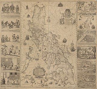
The archaeology of the Philippines is the study of past societies in the territory of the modern Republic of the Philippines, an island country in Southeast Asia, through material culture.
Philippine ceramics are mostly earthenware, pottery that has not been fired to the point of vitrification. Other types of pottery like tradeware and stoneware have been fired at high enough temperatures to vitrify. Earthenware ceramics in the Philippines are mainly differentiated from tradeware and stoneware by the materials used during the process and the temperature at which they are fired. Additionally, earthenware and stoneware pottery can generally be referred to as ceramics that are made with local materials, while tradeware ceramics can generally be referred to as ceramics that are made with non-local materials.
The post-1500s Philippines is defined by colonial powers occupying the land. Whether it be the Spanish, the Americans, or the Japanese, the Philippines were subjugated and shaped by the presence of a hegemonic power enacting dominance over the people, the land, and the culture itself. The respective field of the archaeology of the post-1500s Philippines is a particularly growing and revolutionary field, particularly seen in the archaeology of Stephen Acabado in Ifugao and Grace Barretto-Tesoro in Manila. There were also many important events that had happened during this period. In 1521, Portuguese explorer, Ferdinand Magellan discovered Homonhon Island and called it "Arcigelago de San Lazaro." Magellan became the first European to cross over the Pacific Ocean.

Tradeware ceramics in the Philippines are ceramics produced in different countries and traded within the Philippines. They are often referred to as export ware and became popular due to their kaolin-type clay that was difficult to replicate. Tradeware ceramics in the Philippines range from Pre-Spanish arrival through the Manila Galleon of the Colonial period. Leading scholars in this field are Carl E. Guthe, Li Jian'an, Li Min, Olov Janse, and Robert Fox.
Rwanda's prehistory is a relatively unexplored concept as compared to other regions of Africa. Most archaeological works regarding Rwanda past 1994 are associated with conflict and ethnic violence. However more recently, archaeologists have been attempting to focus on archaeological works from the first and second millennia A.D. For example, some archaeological research has been focusing on the Nyiginya Kingdom, which is the pre-colonial predecessor of the current Rwandan state. Other research has been focusing on the excavations of the earliest agricultural sites, likely from the Iron Age, as well as ceramics to indicate chronology of when certain agricultural groups migrated to Rwanda.
Lovea is a modern village and archaeological site located in the Puok district of Siem Reap province, Cambodia. Lovea's circular mound measures 210 metres (690 ft) north–south, and 312 metres (1,024 ft) east-west, and is notable for its two circular embankments or moats that surround the mound, an unusual habitation pattern in this part of Cambodia. The site was first identified and described by French archaeologist Louis Malleret in the 1950s. More recent archaeological excavations have identified burials and residential occupation. The site dates from the second century BCE through the Angkor period to the present day.
References
- Tenazas, R.C.P. A report on the archeology of the Locsin-University of San Carlos Excavations in Pila, Laguna.
- Vitales, T.J. Archaeological research in the Laguna de Bay area, Philippines. Last accessed 2015-05-18
- Valdes, C.O. Pila in Ancient Times. Last accessed 2015-05-18