
Venezuela is a country in South America, bordering the Caribbean Sea and the North Atlantic Ocean, between Colombia and Guyana. It is situated on major sea and air routes linking North and South America. Located at the northernmost end of South America, Venezuela has a total area of 912,050 km2 (352,140 sq mi) and a land area of 882,050 km2 (340,560 sq mi). It is the 32nd largest country and is slightly smaller than Egypt, or half the size of Mexico. Shaped roughly like an inverted triangle, the country has a 2,800 km (1,700 mi) long coastline. It is bound on the north by the Caribbean Sea and the Atlantic Ocean, on the east by Guyana, on the south by Brazil, and on the west by Colombia. It has the 55th largest Exclusive Economic Zone of 471,507 km2 (182,050 sq mi). Its maritime territory borders Trinidad and Tobago, Dominica, the Dominican Republic, Grenada, St. Kitts and Nevis, St. Vincent and the Grenadines, France, the United Kingdom, the Netherlands, and the United States. Venezuela also claims the region of Guayana Esequiba, currently under the control of Guyana.

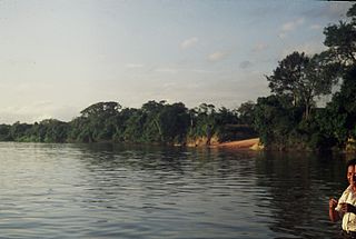
The Orinoco is one of the longest rivers in South America at 2,250 kilometres (1,400 mi). Its drainage basin, sometimes known as the Orinoquia, covers 989,000 km2 (382,000 sq mi), with 76.3 percent of it in Venezuela and the remainder in Colombia. It is the fourth largest river in the world by discharge volume of water. The Orinoco River and its tributaries are the major transportation system for eastern and interior Venezuela and the Llanos of Colombia. The environment and wildlife in the Orinoco's basin are extremely diverse.

Vichada Department is a department of the Republic of Colombia in South America. Vichada is located in the eastern plains of Colombia, in the Orinoquía Region within the Orinoco river basin bordering the Bolivarian Republic of Venezuela to the north and east. To the north the department also borders with Arauca Department, to the northwest with Casanare Department, to the west with Meta Department, to the southwest narrowly bordering with Guaviare Department and to the south with Guainía Department. The department is the second largest in Colombia and scarcely populated in comparison to other departments.

A blackwater river is a type of river with a slow-moving channel flowing through forested swamps or wetlands. Most major blackwater rivers are in the Amazon Basin and the Southern United States. The term is used in fluvial studies, geology, geography, ecology, and biology. Not all dark rivers are blackwater in that technical sense. Some rivers in temperate regions, which drain or flow through areas of dark black loam, are simply black due to the color of the soil; these rivers are black mud rivers. There are also black mud estuaries.

The Llanos is a vast tropical grassland plain situated to the east of the Andes in Colombia and Venezuela, in northwestern South America. It is an ecoregion of the tropical and subtropical grasslands, savannas, and shrublands biome.

The Apure River is a river of southwestern Venezuela, formed by the confluence of the Sarare and Uribante near Guasdualito, in Venezuela, at 7°15′N70°40′W, and flowing across the Llanos into the Orinoco. It provides significant transportation in the area.

Puerto Carreño, translation English: Puerto Carreno, lit. 'Port Carreno' is the departmental capital city, and a municipality combined of the department of Vichada in the Llanos of Colombia located on the Orinoco River. Puerto Carreño is best-known as a tourist gateway to hundreds of adventure, ecological and sustainable tourism destinations, it is well-known for peacock bass fishing on the Vita River, Indigenous artisans from the Orinoquia, as a river port trade center, and as a frontier settlement that has become the capital of the second largest department (province) in Colombia.

The Orinoco crocodile is a critically endangered crocodile. Its population is very small, and they can only be found in the Orinoco river basin in Venezuela and Colombia. Extensively hunted for their skins in the 19th and 20th centuries, it is one of the most endangered species of crocodiles. It is a very large species of crocodilian; males have been reported up to 6.8 m in the past, weighing over 900 kg (2,000 lb), but such sizes do not exist today, 5.2 m being a more widely accepted maximum size. A large male today may attain 4.2 m in length and can weigh up to 450 kg (1,000 lb), while females are substantially smaller with the largest likely to weigh around 225 kg (496 lb). Sexual dimorphism is not as profound as in other crocodilian species. The coloration is light even in adults.

The Meta River is a major left tributary of the Orinoco River in eastern Colombia and southern Venezuela, South America. The Meta originates in the Eastern Ranges of the Andes and flows through the Meta Department, Colombia as the confluence of the Humea, Guatiquía and Guayuriba rivers. It flows east-northeastward across the Llanos Orientales of Colombia following the direction of the Meta Fault. The Meta forms the northern boundary of Vichada Department, first with Casanare Department, then with Arauca Department, and finally with Venezuela, down to Puerto Carreño where it flows into the Orinoco.

The Arauca River rises in the Andes Mountains of north-central Colombia and ends at the Orinoco in Venezuela. For part of its run it is the boundary between Colombia and Venezuela. The major city on its banks is Arauca, Colombia and El Amparo, Venezuela.

The Guaviare is a tributary of the Orinoco in Colombia. It flows together with the upper Orinoco, which it clearly surpasses in length and water flow. Thus, the Guaviare is hydrologically the main stream of the Orinoco system.

The Cordillera Oriental is the widest of the three branches of the Colombian Andes. The range extends from south to north dividing from the Colombian Massif in Huila Department to Norte de Santander Department where it splits into the Serranía del Perijá and the Cordillera de Mérida in Venezuelan Andes. The highest peak is Ritacuba Blanco at 5,410 m (17,750 ft) in the Sierra Nevada del Cocuy.

The Ventuari River is the largest tributary of the Orinoco in southern Venezuela. The Ventuari flows from south-central Venezuela in the Guiana Highlands southwest into the Orinoco River. It is 520 km (320 mi) long and its major tributary is the Manapiare River.

The slate-colored hawk is a species of bird of prey in the family Accipitridae: the hawks, eagles, and allies.

Because of its natural structure, Colombia can be divided into six distinct natural regions. These consist of the Andean Region, covering the three branches of the Andes mountains found in Colombia; the Caribbean Region, covering the area adjacent to the Caribbean Sea; the Pacific Region adjacent to the Pacific Ocean; the Orinoquía Region, part of the Llanos plains mainly in the Orinoco river basin along the border with Venezuela; the Amazon Region, part of the Amazon rainforest; and finally the Insular Region, comprising the islands in both the Atlantic and Pacific Oceans. Colombia is located in South America.
The Caura, is a tributary of the Orinoco River, located in Bolívar State in Venezuela. Its flow is the second after the Caroni River among the affluents of the Orinoco River, with almost 3,544 cubic metres per second (125,200 cu ft/s). The river is inhabited by both the Ye'kuana and Sanema indigenous groups.

The Guayabero River is a river of Colombia. It is primarily located in the Meta Department, forming a portion of its border with the Guaviare Department. It is part of the Orinoco River basin. Its confluence with the Ariari River gives rise to the Guaviare River, one of the Orinoco's largest tributaries.
Caquetío is an extinct Arawakan language family. The language was spoken along the shires of Lake Maracaibo, in the coastal areas of the Venezuelan sate of Falcón, and on the Dutch islands of Aruba, Bonaire and Curaçao.

The Negro–Branco moist forests (NT0143) is an ecoregion of tropical moist broadleaf forest to the east of the Andes in southern Venezuela, eastern Colombia and northern Brazil, in the Amazon biome. It lies on the watershed between the Orinoco and Rio Negro basins. It includes both blackwater and whitewater rivers, creating different types of seasonally flooded forest. The vegetation is more typical of the Guiana region than the Amazon.
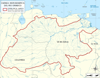
The Orinoco Basin is the part of South America drained by the Orinoco river and its tributaries. The Orinoco watershed covers an area of about 990000 km2, making it the third largest in South America, covering most of Venezuela and eastern part of Colombia.
