| Aro River | |
|---|---|
 | |
| Location | |
| Country | Venezuela |
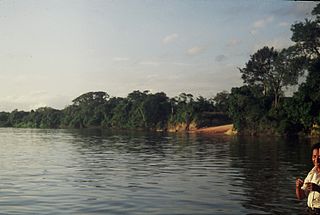
Aro River is a river of Venezuela. It is part of the Orinoco River basin.
| Aro River | |
|---|---|
| | |
| Location | |
| Country | Venezuela |
Aro River is a river of Venezuela. It is part of the Orinoco River basin.

The Orinoco is one of the longest rivers in South America at 2,140 km (1,330 mi). Its drainage basin, sometimes known as the Orinoquia, covers ca 1 million km2, with 65% of it in Venezuela and the 35% in Colombia. It is the fourth largest river in the world by discharge volume of water due to the high precipitation throughout its catchment area. The Orinoco River and its tributaries are the major transportation system for eastern and interior Venezuela and the Llanos of Colombia. The environment and wildlife in the Orinoco's basin are extremely diverse.

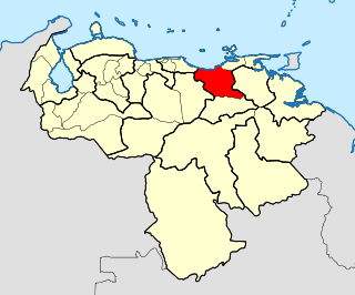
Anzoátegui State is one of the 23 states of Venezuela, located in the northeastern region of the country. Anzoátegui is well known for its beaches that attract many visitors. Its coast consists of a single beach approximately 100 km (62 mi) long. Its capital is the city of Barcelona, and significant cities include Puerto la Cruz and El Tigre.

The Battle of Warsaw took place near Warsaw on July 28–July 30 [O.S. July 18–20] 1656, between the armies of the Polish–Lithuanian Commonwealth and Sweden and Brandenburg. It was a major battle in the Second Northern War between Poland and Sweden in the period 1655–1660, also known as The Deluge. According to Hajo Holborn, it marked "the beginning of Prussian military history".

The Apure River is a river of southwestern Venezuela, formed by the confluence of the Sarare and Uribante near Guasdualito, in Venezuela, at 7°15′N70°40′W, and flowing across the Llanos into the Orinoco. It provides significant transportation in the area.

Blackdown is a hamlet and civil parish in the Warwick district of Warwickshire, England. Blackdown is about two miles north of Leamington Spa, between Leamington, Warwick and Kenilworth. According to the 2001 Census, it had a population of 128. From the 2011 Census, population details are included with Old Milverton.

Essequibo was a Dutch colony in the Guianas and later a county on the Essequibo River in the Guiana region on the north coast of South America. It was a colony of the Dutch West India Company between 1616 and 1792 and a colony of the Dutch state from 1792 until 1815. It was merged with Demerara in 1812 by the British who took control. It formally became a British colony in 1815 until Demerara-Essequibo was merged with Berbice to form the colony of British Guiana in 1831. In 1838, it became a county of British Guiana till 1958. In 1966, British Guiana gained independence as Guyana and in 1970 it became a republic as the Co-operative Republic of Guyana. It was located around the lower course of the Essequibo River.

Guárico River is a river in Venezuela.

Merrymeeting Bayis a large freshwater tidal bay located in the U.S. state of Maine. Merrymeeting Bay's unusual geography defies common landform terms. It is not what is usually meant by the word bay. It is somewhat like an estuary but it has fresh water with very little salt. Geologically it is described as an "inland delta" and biologically as "tidal riverine."
The Los Hermanos Archipelago is a chain of seven rocky barren islets that is part of the Federal Dependencies of Venezuela, at 11°45′N64°25′W.
The Caura, is a tributary of the Orinoco River, located in Bolívar State in Venezuela. Its flow is the second after the Caroni River among the affluents of the Orinoco River, with almost 3,544 cubic metres per second (125,200 cu ft/s). The river is inhabited by both the Ye'kuana and Sanema indigenous groups.
The Roman Catholic Diocese of Barcelona in Venezuela is located in the city of Barcelona in the ecclesiastical province of Cumaná in Venezuela.
The Portuguesa River is a river of Venezuela. It is part of the Orinoco River basin, and is a tributary of the Apure River.

Ethyldienolone, also known as 17α-methyl-19-nor-δ9-testosterone, as well as 17α-methylestra-4,9-dien-17β-ol-3-one, is synthetic, orally active anabolic-androgenic steroid (AAS) and a 17α-alkylated derivative of 19-nortestosterone. It is slightly more active than methyltestosterone when given orally. Ethyldienolone is closely related to dienolone and methyldienolone.
The Parima Mountains are a mountain range of the Guiana Shield in South America.

Windmill Hill is a chalk hill running alongside the A3(M) in the East Hampshire district of Hampshire, England, overlooking Chalton to the east, and Clanfield to the west. It measures 193 metres above sea level and is named so because of Chalton Windmill which sits upon its summit. This windmill is a Grade II listed building which lay derelict until the late 1970s, when it was restored and converted into a private residence.
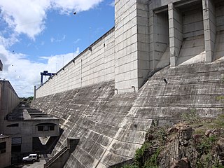
The Macagua Dam, officially known as Antonio José de Sucre, is an embankment dam with concrete gravity sections on the Caroní River in Ciudad Guayana, Bolívar State, Venezuela. It is 10 kilometres (6.2 mi) upstream from the confluence of the Caroni and Orinoco Rivers, 81 km (50 mi) downstream of the Guri Dam and 22 kilometres (14 mi) downstream of the Caruachi Dam. The dam's main purpose is hydroelectric power generation and it was later named after Antonio José de Sucre.

The Eastern Region is one of the 10 administrative regions in which Venezuela was divided for its development plans; it comprises the states of Anzoátegui, Monagas, and Sucre.

Sutton Ecology Centre Grounds is a 1.3 hectare Local Nature Reserve and Site of Borough Importance for Nature Conservation, Grade 1, in Carshalton in the London Borough of Sutton. It is owned by Sutton Council and managed by the Council together with the Friends of Sutton Ecology Centre.
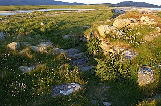
Dun Vulan Broch is an Iron Age broch in South Uist, Scotland.
The Samsung Galaxy F62 is a mid-range Android smartphone manufactured by Samsung Electronics as part of its Galaxy F series. It is the second phone to be released in the series. It has a 7000 mAh battery, a quad camera setup with a 64 MP main camera, as well as a 12 MP ultrawide camera, a 5 MP macro camera and a 5 MP depth sensor, a 6.7 in (17 cm) Super AMOLED Plus display and the Exynos 9825 SoC previously used in the Samsung Galaxy Note 10 and Note 10+ flagship smartphones.
7°58′57″N64°09′56″W / 7.9825°N 64.1656°W