
Tanzania, officially the United Republic of Tanzania, is a country in East Africa within the African Great Lakes region. It is bordered by Uganda to the northwest; Kenya to the northeast; the Indian Ocean to the east; Mozambique and Malawi to the south; Zambia to the southwest; and Rwanda, Burundi, and the Democratic Republic of the Congo to the west. According to the 2022 national census, Tanzania has a population of around 62 million, making it the most populous country located entirely south of the equator.

Arusha City is a Tanzanian city, with a population of 617,631, and the regional capital of the Arusha Region, with a population of 2,356,255.

Moshi is a municipality and the capital of Kilimanjaro region in the north eastern Tanzania. As of 2017, the municipality has an estimated population of 201,150 and a population density of 3,409 persons per km2. In the last official census of 2022, the municipality had a population of 221,733. The municipality is situated on the lower slopes of Mount Kilimanjaro, a dormant volcano that is the highest mountain in Africa. The name Moshi has been reported to refer to the smoke that emanates from the nearby mountain. The municipality covers about 59 square kilometres (23 sq mi) and is the smallest municipality in Tanzania by area.

Ngorongoro Conservation Area is a protected area and a UNESCO World Heritage Site located in Ngorongoro District, 180 km (110 mi) west of Arusha City in Arusha Region, within the Crater Highlands geological area of northeastern Tanzania. The area is named after Ngorongoro Crater, a large volcanic caldera within the area. The Ngorongoro Conservation Area Authority administers the conservation area, an arm of the Tanzanian government, and its boundaries follow the boundary of the Ngorongoro District in Arusha Region. The western portion of the park abuts the Serengeti National Park, and the area comprising the two parks and Kenya's Maasai Mara game reserve is home to Great Migration, a massive annual migration of millions of wildebeest, zebras, gazelles, and other animals. The conservation area also contains Olduvai Gorge, one of the most important paleoanthropological sites in the world.
Tanzanian Hip-hop, which is sometimes referred to Bongo Flava by many outside of Tanzania's hip hop community, encompasses a large variety of different sounds, but it is particularly known for heavy synth riffs and an incorporation of Tanzanian pop.

The African Court on Human and Peoples' Rights, also known simply as the African Court, is an international court established by member states of the African Union (AU) to implement provisions of the African Charter on Human and Peoples' Rights. Seated in Arusha, Tanzania, it is the judicial arm of the AU and one of three regional human rights courts.
Arusha Region is one of Tanzania's 31 administrative regions and is located in the northeast of the country. The region's capital and largest city is the city of Arusha. The region is bordered by Kajiado County and Narok County in Kenya to the north, the Kilimanjaro Region to the east, the Manyara and Singida Regions to the south, and the Mara and Simiyu regions to the west. Arusha Region is home to Ngorongoro Conservation Area, a UNESCO World Heritage Site. The region is comparable in size to the combined land and water areas of the state of Maryland in the United States.
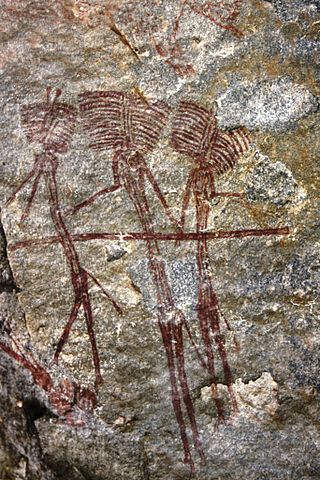
Mguu wa Zuberi is the local name for a place in the Arusha Region in the north of Tanzania.
Makumira is a small town located in Poli ward of Meru District in Arusha Region of northern Tanzania. It lies on the slope of Mount Meru, the fifth-highest mountain in Africa. Makumira is about 16 kilometres from the city of Arusha on the main road, A23. The neighboring villages are Tengeru and Usa River.
Selian is a small river which runs off the southern slopes of Mount Meru in the northern Arusha region of Tanzania, East Africa. The town of Arusha resides to the east of Selian River.

The Tanzania national rugby union team represents Tanzania in international rugby union. They are known as the Twigas. Tanzania is a member of the International Rugby Board.
The Kondoa Rock-Art Sites or Kondoa Irangi Rock Paintings are a series of ancient paintings on rockshelter walls in central Tanzania. The Kondoa region was declared a UNESCO World Heritage Site in 2006 because of its impressive collection of rock art. These sites were named national monuments in 1937 by the Tanzania Antiquities Department. The paintings are located approximately nine kilometres east of the main highway (T5) from Dodoma to Babati, about 20 km north of Kondoa town, in Kondoa District of Dodoma Region, Tanzania. The boundaries of the site are marked by concrete posts. The site is a registered National Historic Sites of Tanzania.
The following outline is provided as an overview of and topical guide to Tanzania:
Bangata is an administrative ward in the Arusha Rural District of the Arusha Region of Tanzania. According to the 2012 census, the ward has a total population of 9,136.
Kisongo is an administrative ward and small town in the Arusha Rural District of the Arusha Region of Tanzania. According to the 2022 census, the ward has a total population of 12,519. It is located in the outskirts of Arusha, about 7 km west of Arusha Airport. The word Kisongo comes from one of the four major Masai Clan families, Kiputiei, Loitai, Purko and Kisongo.
The Isinya–Singida High Voltage Power Line is a high voltage electricity power line, under construction, connecting the high voltage substation at Isinya, Kenya to another high voltage substation at Singida, Tanzania.
Tengeru is a market-town in the Arusha Region of northern Tanzania. Located below Mount Meru on the eastern edge of the eastern branch of the Great Rift Valley, surrounding Lake Duluti, Tengeru has a temperate climate. The town is thirteen kilometres east of the city of Arusha.
Arusha Secondary School is a secondary school in Arusha, Tanzania, the first school in Tanzania to be headed by a Tanzanian woman educated in the United States.

The Momela Lakes are seven shallow lakes located within Arusha National Park namely: Big Momela, Small Momela, El Kekhotoito, Kusare, Rishateni, Lekandiro and Tulusia. Entrance to the park is in Village Momella, Meru District of Arusha Region, Tanzania
Mungu Crater is a volcanic crater in Oljoro ward and Mateves ward in Arusha Rural District located in Arusha Region, Tanzania. The crater is 1.22 km (0.76 mi) in diameter at its widest and 1,030 metres (1,130 yd) deep. Inside the crater is surrounded by forest whilst the crater floor is a seasonal swamp.

 Norway 's King Harald, Queen Sonja and Princess Märtha Louise
  South Africa 's Thabo Mbeki and Zanele Mbeki
 United States 's Bill Clinton