Stephenson is a medieval patronymic surname meaning "son of Stephen". The earliest public record is found in the county of Huntingdonshire in 1279. There are variant spellings including Stevenson. People with the surname include:

Ashley Judd is an American actress. She grew up in a family of performing artists, the daughter of country music singer Naomi Judd and the half-sister of country music singer Wynonna Judd. Her acting career has spanned more than three decades, and she has become heavily involved in global humanitarian efforts and political activism. Judd made her television debut in 1991 with a guest role on Star Trek: The Next Generation and her film debut in 1992's Kuffs.

Mary-Kate Olsen is an American businesswoman, fashion designer, equestrian, and former actress. Her acting career began at the age of nine months, with her sharing the role of Michelle Tanner with her twin sister Ashley Olsen in the television sitcom Full House (1987–1995). They also starred in numerous films together.

Mary-Kate Olsen and Ashley Fuller Olsen, also known as the Olsen twins, are American fashion designers and former actresses. Mary-Kate and Ashley made their acting debut as infants playing Michelle Tanner on the television sitcom Full House (1987–1995). As they grew older, they began starring in other television shows, films, and media through their own production company, Dualstar. The twins became preteen icons, and some of the wealthiest women in the entertainment industry at a young age.

Christopher John "Topher" Grace is an American actor. He is known for portraying Eric Forman in the teen sitcoms That '70s Show and That '90s Show, Eddie Brock / Venom in Sam Raimi's film Spider-Man 3, Pete Monash in Win a Date with Tad Hamilton!, Carter Duryea in In Good Company, Edwin in Predators, Getty in Interstellar, Adrian Yates in American Ultra, and David Duke in Spike Lee's film BlacKkKlansman. His other film roles include Traffic, Mona Lisa Smile, Valentine's Day, Take Me Home Tonight, The Big Wedding, War Machine, Breakthrough, and Irresistible. He also starred as Tom Hayworth in the ABC comedy series Home Economics.
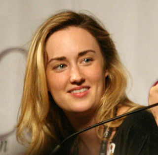
Ashley Suzanne Johnson is an American actress. She became known as a child actress for her role as Chrissy Seaver on the sitcom Growing Pains (1990–1992). As an adult, her television roles include Amber Ahmed on The Killing (2011–2012) and Patterson on Blindspot (2015–2020). She has appeared in films such as What Women Want (2000), The Help (2011), and Much Ado About Nothing (2012), and is a cast member on the Dungeons & Dragons web series Critical Role (2015–present). She became the president of the show's charity branch, the Critical Role Foundation, upon its launch in 2020.

Just My Luck is a 2006 American romantic comedy film directed by Donald Petrie, from a screenplay by I. Marlene King and Amy B. Harris, starring Lindsay Lohan, Chris Pine, Faizon Love, Missi Pyle, and McFly. It tells the story of Ashley Albright who works in public relations and is the luckiest person in Manhattan, while Jake Hardin is a janitor and would-be music producer who seems to have terrible luck until their good and bad luck is switched upon kissing each other at a masquerade ball which changes both their lives and leads them to meet each other once again.

Ashley Michelle Tisdale is an American actress and singer. During her childhood, she was featured in over 100 advertisements and had minor roles in television and theatre. She achieved mainstream success as Maddie Fitzpatrick in the Disney Channel teen sitcom The Suite Life of Zack & Cody (2005–2008). This success was heightened when she starred as Sharpay Evans in the High School Musical film series (2006–2008). The success of the films led to Tisdale's signing with Warner Bros. Records and subsequently releasing her debut studio album, Headstrong (2007), which was a commercial success, earning a gold certification from the Recording Industry Association of America (RIAA). Tisdale provided the voice of Candace Flynn in the Disney Channel animated series Phineas and Ferb (2007–2015).
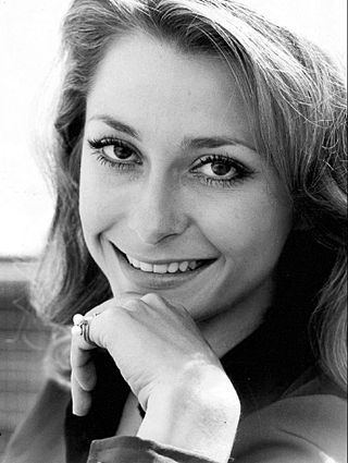
Elizabeth Ann Cole, known professionally as Elizabeth Ashley, is an American actress of theatre, film, and television. She has been nominated for three Tony Awards, winning once in 1962 for Take Her, She's Mine. Ashley was also nominated for the BAFTA and Golden Globe awards for her supporting performance in The Carpetbaggers (1964), and was nominated for an Emmy Award in 1991 for Evening Shade. Elizabeth was a guest on The Tonight Show Starring Johnny Carson 24 times. She appeared in several episodes of In the Heat of the Night as Maybelle Chesboro. She also appeared in an episode of Mannix, "The Dark Hours", in 1974.
Ashley Williams may refer to:

Ashley Greene Khoury is an American actress. She is known for playing Alice Cullen in the film adaptations of Stephenie Meyer's Twilight novels.

Ashley Madekwe is a British actress. She is known for her roles as Bambi in the ITV2 series Secret Diary of a Call Girl (2008–2010), Ashley Davenport in the ABC drama Revenge (2011–2013), and Tituba in the WGN series Salem (2014–2017). For her performance in County Lines (2019), Madekwe was nominated for the BAFTA for Best Supporting Actress.
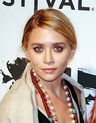
Ashley Fuller Olsen is an American businesswoman, fashion designer and former actress. She began her acting career at the age of nine months, sharing the role of Michelle Tanner with her twin sister Mary-Kate Olsen in the television sitcom Full House (1987–1995). They also starred in numerous films together.
Tesoro or El Tesoro may refer to:
Ashley Spencer is the name of:
Ashley Lawrence, is a Canadian soccer player.
Ashley Bell may refer to:

Ashley Jini Park is an American actress and musician. She is best known for her portrayal of Mindy Chen on the Netflix comedy series Emily in Paris. She originated the role of Gretchen Wieners in the Broadway musical Mean Girls, for which she was nominated for a Tony Award for Best Actress in a Featured Role in a Musical.
Ashley Grace may refer to: