Asikuma-Odoben-Brakwa District | |
|---|---|
Seal | |
| Nickname: AOB | |
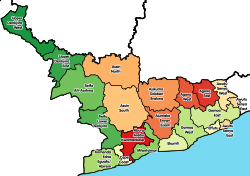 Districts of Central Region | |
 Asikuma-Odoben-Brakwa District Location of Asikuma-Odoben-Brakwa District within Central | |
| Coordinates: 5°34′51.96″N0°59′39.84″W / 5.5811000°N 0.9944000°W | |
| Country | |
| Region | |
| Capital | Breman Asikuma |
| Government | |
| • Member of Parliament | Hon. Alhassan Kobina Ghansah |
| Area | |
• Total | 765 km2 (295 sq mi) |
| Population (2021) | |
• Total | 126,993 [1] |
| Time zone | UTC+0 (GMT) |
| ISO 3166 code | GH-CP-AO |
| Website | Official Website |
Asikuma-Odoben-Brakwa District is one of the twenty-two districts in Central Region, Ghana. Originally created as an ordinary district assembly in 1988, which was created from the Breman-Ajumako-Enyan District Council from 1974 to 1978. The district assembly was located in the northeast part of Central Region and had Breman Asikuma as its capital town. [2]