Look up Assam in Wiktionary, the free dictionary.
Assam is a state in northeastern India.
Contents
Assam may also refer to:
Assam is a state in northeastern India.
Assam may also refer to:
Bihar is a state in India.

Assam is a state in northeastern India, south of the eastern Himalayas along the Brahmaputra and Barak River valleys. Assam covers an area of 78,438 km2 (30,285 sq mi). The state is bordered by Bhutan and Arunachal Pradesh to the north; Nagaland and Manipur to the east; Meghalaya, Tripura, Mizoram and Bangladesh to the south; and West Bengal to the west via the Siliguri Corridor, a 22-kilometre-wide (14 mi) strip of land that connects the state to the rest of India. Assamese and Boro are the official languages of Assam, while Bengali is an official language in the three districts of Barak Valley.
Assamese may refer to:

Sylhet Division is the northeastern division of Bangladesh. It is bordered by the Indian states of Meghalaya, Assam and Tripura to the north, east and south respectively, and by the Bangladeshi divisions of Chittagong to the southwest and Dhaka and Mymensingh to the west. Prior to 1947, it included the subdivision of Karimganj. However, Karimganj was inexplicably severed from Sylhet by the Radcliffe Boundary Commission. According to Niharranjan Ray, it was partly due to a plea from a delegation led by Abdul Matlib Mazumdar.

The Bengal Presidency, officially the Presidency of Fort William in Bengal and later Bengal Province, was a territorial unit of British India. It was the largest presidency among all the presidencies of British India. At the height of its territorial jurisdiction, it covered large parts of what is now South Asia and Southeast Asia. Bengal proper covered the ethno-linguistic region of Bengal. Calcutta, the city which grew around Fort William, was the capital of the Bengal Presidency. For many years, the Governor of Bengal was concurrently the Governor-General of India and Calcutta was the de facto capital of India until 1911.

The history of Bengal is intertwined with the history of the broader Indian subcontinent and the surrounding regions of South Asia and Southeast Asia. It includes modern-day Bangladesh and the Indian states of West Bengal, Tripura and Assam's Karimganj district, located in the eastern part of the Indian subcontinent, at the apex of the Bay of Bengal and dominated by the fertile Ganges delta. The region was known to the ancient Greeks and Romans as Gangaridai, a powerful kingdom whose war elephant forces led the withdrawal of Alexander the Great from India. Some historians have identified Gangaridai with other parts of India. The Ganges and the Brahmaputra rivers act as a geographic marker of the region, but also connects the region to the broader Indian subcontinent. Bengal, at times, has played an important role in the history of the Indian subcontinent.
The Punjab region is an area of South Asia stretching from central and eastern Pakistan to northwest India.
Dibrugarh is an industrial city in Upper Assam with sprawling tea gardens. It is located 435 kms East from the state capital of Dispur. It serves as the headquarters of Dibrugarh district in the state of Assam in India. Dibrugarh serves as the headquarters of the Sonowal Kachari Autonomous Council, which is the governing council of the Sonowal Kachari tribe.

The provinces of India, earlier presidencies of British India and still earlier, presidency towns, were the administrative divisions of British governance on the Indian subcontinent. Collectively, they have been called British India. In one form or another, they existed between 1612 and 1947, conventionally divided into three historical periods:
Tinsukia district is one of the 34 administrative districts in the state of Assam, India. The district headquarters is located at Tinsukia city. The district occupies an area of 3790 km2.

The history of Assam is the history of a confluence of people from the east, west, south and the north; the confluence of the Austroasiatic, Tibeto-Burman (Sino-Tibetan), Tai and Indo-Aryan cultures. Although invaded over the centuries, it was never a vassal or a colony to an external power until the third Burmese invasion in 1821, and, subsequently, the British ingress into Assam in 1824 during the First Anglo-Burmese War.
Eastern Bengal and Assam was an province of India between 1905 and 1912. Headquartered in the city of Dacca, it covered territories in what are now Bangladesh, Northeast India and Northern West Bengal.
Colonial Assam (1826–1947) refers to the period in the history of Assam between the signing of the Treaty of Yandabo and the Independence of India when Assam was under British colonial rule. The political institutions and social relations that were established or severed during this period continue to have a direct effect on contemporary events. The legislature and political alignments that evolved by the end of the British rule continued in the post Independence period. The immigration of farmers from East Bengal and tea plantation workers from Central India continue to affect contemporary politics, most notably that which led to the Assam Movement and its aftermath.

The Economy of Assam is largely agriculture based with 69% of the population engaged in it.
Georgia most commonly refers to:

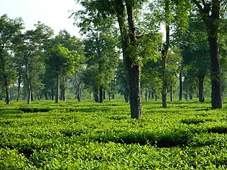
India is the second largest producer of tea in the world after China, including the famous Assam tea and Darjeeling tea. Tea is the 'State Drink' of Assam. Following this the former Planning Commission Deputy Chairman, Montek Singh Ahluwalia had plans to officially recognise tea as the Indian "National Drink" in 2013. According to the ASSOCHAM report released in December 2011, India is the world's largest consumer of tea, consuming nearly 30% of global output. India is also the second-largest exporter of tea, after China.
The city of Chattogram (Chittagong) is traditionally centred around its seaport which has existed since the 4th century BCE. One of the world's oldest ports with a functional natural harbor for centuries, Chittagong appeared on ancient Greek and Roman maps, including on Ptolemy's world map. Chittagong port is the oldest and largest natural seaport and the busiest port of Bay of Bengal. It was located on the southern branch of the Silk Road. The city was home to the ancient independent Buddhist kingdoms of Bengal like Samatata and Harikela. It later fell under of the rule of the Gupta Empire, the Gauda Kingdom, the Pala Empire, the Chandra Dynasty, the Sena Dynasty and the Deva Dynasty of eastern Bengal. Arab Muslims traded with the port from as early as the 9th century. Historian Lama Taranath is of the view that the Buddhist king Gopichandra had his capital at Chittagong in the 10th century. According to Tibetan tradition, this century marked the birth of Tantric Buddhism in the region. The region has been explored by numerous historic travellers, most notably Ibn Battuta of Morocco who visited in the 14th century. During this time, the region was conquered and incorporated into the independent Sonargaon Sultanate by Fakhruddin Mubarak Shah in 1340 AD. Sultan Ghiyasuddin Azam Shah constructed a highway from Chittagong to Chandpur and ordered the construction of many lavish mosques and tombs. After the defeat of the Sultan of Bengal Ghiyasuddin Mahmud Shah in the hands of Sher Shah Suri in 1538, the Arakanese Kingdom of Mrauk U managed to regain Chittagong. From this time onward, until its conquest by the Mughal Empire, the region was under the control of the Portuguese and the Magh pirates for 128 years.
Orissa is the former name of the state of Odisha in India.
Assam Province was a province of British India, created in 1912 by the partition of the Eastern Bengal and Assam Province. Its capital was in Shillong.

The 1947 Sylhet referendum was held in the Sylhet District of the Assam Province of British India to decide whether the district would remain in Undivided Assam and therefore within the post-independence Dominion of India, or leave Assam for East Bengal and consequently join the newly-created Dominion of Pakistan. The referendum's turnout was in favour of joining the Pakistani union; however, the district's Karimganj subdivision remained within the Indian state of Assam.