
Many climbing routes have a grade that reflects the technical difficulty—and in some cases the risks and commitment level—of the route. The first ascensionist can suggest a grade, but it will be amended to reflect the consensus view of subsequent ascents. While many countries with a strong tradition of climbing developed grading systems, a small number of grading systems have become internationally dominant for each type of climbing, which has contributed to the standardization of grades worldwide. Over the years, grades have consistently risen in all forms of climbing, helped by improvements in climbing technique and equipment.
Südliche Weinstraße is a district (Kreis) in the south of Rhineland-Palatinate, Germany. Neighboring districts are Südwestpfalz, Bad Dürkheim, the district-free city Neustadt (Weinstraße), Rhein-Pfalz-Kreis, Germersheim, and the French département Bas-Rhin. The district-free city Landau is surrounded by the district.
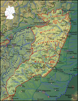
The Palatinate Forest, sometimes also called the Palatine Forest, is a low-mountain region in southwestern Germany, located in the Palatinate in the state of Rhineland-Palatinate. The forest is a designated nature park covering 1,771 km2 and its highest elevation is the Kalmit.

In the history of rock climbing, the three main sub-disciplines—bouldering, single-pitch climbing, and big wall climbing—can trace their origins to late 19th-century Europe. Bouldering started in Fontainebleau, and was advanced by Pierre Allain in the 1930s, and John Gill in the 1950s. Big wall climbing started in the Dolomites, and was spread across the Alps in the 1930s by climbers such as Emilio Comici and Riccardo Cassin, and in the 1950s by Walter Bonatti, before reaching Yosemite where it was led in the 1950s to 1970s by climbers such as Royal Robbins. Single-pitch climbing started pre-1900 in both the Lake District and in Saxony, and by the late-1970s had spread widely with climbers such as Ron Fawcett (Britain), Bernd Arnold (Germany), Patrick Berhault (France), Ron Kauk and John Bachar (USA).

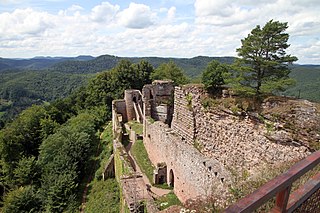
Trifels Castle is a reconstructed medieval castle at an elevation of 500 m (1,600 ft) near the small town of Annweiler, in the Palatinate region of southwestern Germany. It is located high above the Queich valley within the Palatinate Forest on one peak of a red sandstone mountain split into three. Trifels Castle is on the peak of the Sonnenberg, and on both of the other two rock elevations there are castle ruins: Anebos Castle and Scharfenberg Castle.

Gossersweiler-Stein is a municipality in Südliche Weinstraße district, in Rhineland-Palatinate, western Germany.

Ramberg is a municipality in Südliche Weinstraße district, in Rhineland-Palatinate, western Germany.
Annweiler am Trifels is a Verbandsgemeinde in the Südliche Weinstraße district, in Rhineland-Palatinate, Germany. The seat of the municipality is in Annweiler am Trifels.

The Queich is a tributary of the Rhine, which rises in the southern part of the Palatinate Forest, and flows through the Upper Rhine valley to its confluence with the Rhine in Germersheim. It is 52 kilometres (32 mi) long and is one of the four major drainage systems of the Palatinate Forest along with the Speyerbach, Lauter and Schwarzbach. The Queich flows through the towns Hauenstein, Annweiler am Trifels, Siebeldingen, Landau, Offenbach an der Queich and Germersheim.
The castle of Neuscharfeneck is a ruin and a cultural monument above Ramberg and Dernbach on the territory of an exclave of Flemlingen in the district of Südliche Weinstraße in the west German state of Rhineland-Palatinate.
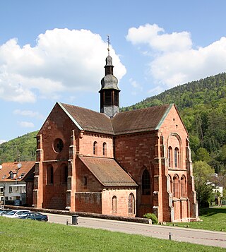
Eusserthal Abbey was a Cistercian abbey in Eusserthal near Annweiler am Trifels in the Rhineland-Palatinate, Germany. All that now remains of it is the front portion of the abbey church, which is now used as a parish church.
The Wasgau is a Franco-German hill range in the German state of Rhineland-Palatinate and the French departments of Bas-Rhin and Moselle. It is formed from the southern part of the Palatine Forest and the northern part of the Vosges mountains, and extends from the River Queich in the north over the French border to the Col de Saverne in the south.

The Bride and Groom is a double rock pinnacle, about 26 metres (85 ft) high, near the small German town of Dahn in the state of Rhineland-Palatinate and in the southern Palatine Forest, the German half of the Wasgau region.

Scharfenberg Castle, is the ruin of a medieval rock castle in the Palatine Forest in the German state of Rhineland-Palatinate. It is situated above the small South Palatine town of Annweiler.

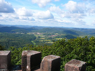
The Hohenberg is a 552 m above sea level (NN) high hill in the Palatinate Forest, in the municipalities of Birkweiler, Queichhambach and Siebeldingen. At its summit is an observation tower, a refuge hut and starting ramps for hang gliders.

The Frankenburg is a natural monument with the ruins of a rock castle in the county of Südliche Weinstraße in the German state of Rhineland-Palatinate. It lies above the Modenbach valley on a rocky outcrop of the Frankenberg called the Frankenfelsen and was built to guard the road opposite Meistersel Castle.
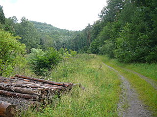
The Holpertal is a valley, just one and a half kilometres long, in the central Palatine Forest of Germany. It lies within the municipality of Ramberg in the county of Südliche Weinstraße in the state of Rhineland-Palatinate. Its V-shaped cross-section was cut by the waters of the Holperbach stream, which has incised deeply into the rock layers of the Lower Bunter. The valley floor climbs from an elevation of about 250 metres to well over 400 metres. Its slopes are covered with mixed forest and sweet chestnut. Whilst at one time, the valley produced raw materials for the traditional broom and brush-making industries, today forestry and tourism predominate.

The Großer Adelberg is a hill, 567 metres high, in the Central Palatinate Forest in Germany.

The Babylonische Turm is a 2,060-metre-high rock needle on the eastern arête of the Kellenspitze (2,238 m), the highest summit in the Tannheim Mountains in the Austrian state of Tyrol. Seen from the south the pinnacle looks like an independent peak. It is important to Alpine climbers because it has numerous climbing routes.
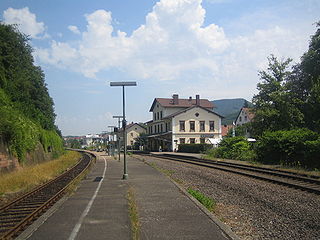
Annweiler am Trifels station is the main station in the town of Annweiler am Trifels in the German state of Rhineland-Palatinate. Deutsche Bahn classifies it as a category 5 station and it has three platform tracks. The station is located in the network of the Verkehrsverbund Rhein-Neckar and belongs to fare zones 181 and 191. Since 2002, Annweiler has also been part of the area served by the Karlsruher Verkehrsverbund using tickets at a transitional rate. Annweiler was always the most important station between Landau (Pfalz) Hbf and Pirmasens Nord and it used to be served by long-distance services.
