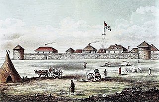
Fort Garry, also known as Upper Fort Garry, was a Hudson's Bay Company trading post located at the confluence of the Red and Assiniboine rivers in or near the area now known as The Forks in what is now central Winnipeg, Manitoba.
Athabasca is an anglicized version of the Cree name for Lake Athabasca in Canada, āthap-āsk-ā-w, meaning "grass or reeds here and there". Most places named Athabasca are found in Alberta, Canada.

The Assiniboine River is a 1,070-kilometre (660 mi) long river that runs through the prairies of Western Canada in Saskatchewan and Manitoba. It is a tributary of the Red River. The Assiniboine is a typical meandering river with a single main channel embanked within a flat, shallow valley in some places and a steep valley in others. Its main tributaries are the Qu'Appelle, Souris, and Whitesand Rivers.
Assiniboia District refers to two historical districts of Canada's Northwest Territories. The name is taken from the Assiniboine First Nation.

Winnipeg South Centre is a federal electoral district in Manitoba, Canada, that has been represented in the House of Commons of Canada from 1925 to 1979 and since 1988.
The vastness of Canada's Northwest Territories meant that for much of its history it was divided into several districts for ease of administration. The number and size of these territorial districts varied as other provinces and territories of Canada were created and expanded. The districts of the Northwest Territories were abolished in 1999 with the creation of the Nunavut territory and the contraction of the Northwest Territories to its current size.

Charleswood is a residential community and neighbourhood in Winnipeg, Manitoba, Canada. It is located in the South-West of the city and is bordered by the neighbourhoods Tuxedo to the East, Fort Whyte to the South, and the Rural Municipality of Headingley on the West. Its boundaries are Roblin and the Assiniboine River to the north, Shaftesbury Boulevard on the East, Wilkes Avenue to the South and the Perimeter Highway to the West.

Charleswood—St. James—Assiniboia—Headingley is a federal electoral district in Manitoba, Canada, that has been represented in the House of Commons of Canada since 1997.
Assiniboia West was a federal electoral district in the Northwest Territories, Canada, that was represented in the House of Commons of Canada from 1896 to 1908.
The Assiniboine are a Native American/First Nations people. Assiniboine may also refer to:
Academy Road is a street in Winnipeg, Manitoba, Canada. It runs from the Maryland Bridge to Wellington Crescent, just west of Route 90, and actually intersects with Wellington at both its east and west ends. Academy Road is located in the residential neighbourhood of River Heights and has many retail stores along it.

St. James-Assiniboia is a major community area in Winnipeg, Manitoba, Canada. As it encapsulates most of the city ward of St. James, which includes the major St. James Street, the area itself is often simply referred to "St. James."
Roblin Park is one of the original neighbourhoods of the Charleswood community in Winnipeg, Manitoba, Canada. It is bounded by Roblin Boulevard to the North, Hartestone Road to the East, bisects the Harte Trail to the south and Scotswood Drive to the West.
Marlton is one of the original neighbourhoods in the area of Charleswood in Winnipeg, Manitoba. It is bordered by Roblin Boulevard, bisects Tom Chester park to the east and Grant Avenue to the south.
Highway 49 and Provincial Trunk Highway 49 is a provincial highway in the Canadian provinces of Saskatchewan and Manitoba. Most of the highway is in the east-central part of Saskatchewan and only a very short section is in Manitoba. It runs from Saskatchewan Highway 35 between the communities of Fosston and Hendon to the Saskatchewan — Manitoba border, before ending at Provincial Trunk Highway 83 south of the community of Benito. The combined highway is about 166.4 kilometres (103.4 mi) in length — 165.2 kilometres (102.7 mi) is in Saskatchewan and 1.2 kilometres (0.7 mi) is in Manitoba.
Touchwood Hills Post Provincial Park is the location of a former Hudson's Bay Company (HBC) fur trading post that existed from 1879 to 1909 in the Touchwood Uplands of the Canadian province of Saskatchewan. In 1986, the site was designated a provincial park. It is located along Highway 15 in the RM of Kellross No. 247, about 10 kilometres (6.2 mi) west of Lestock and 16 kilometres (9.9 mi) east of Punnichy.

The following outline is provided as an overview of and topical guide to Saskatchewan:
Battleford or Battlefords may refer to:
This page is based on this
Wikipedia article Text is available under the
CC BY-SA 4.0 license; additional terms may apply.
Images, videos and audio are available under their respective licenses.