Related Research Articles
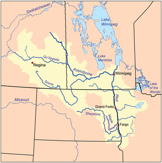
The Maple River is a tributary of the Sheyenne River, about 198 miles (319 km) long, in the Red River Valley of eastern North Dakota in the United States. Via the Sheyenne River, the Red River of the North, Lake Winnipeg and the Nelson River, the Maple is part of the watershed of Hudson Bay.

The Walter F. George Lake, named for Walter F. George (1878–1957), a United States senator from Georgia, is formed on the Chattahoochee River along the state line between Alabama and Georgia. It is also widely known by the name, Lake Eufaula – particularly in Alabama, where the state legislature passed a resolution on June 25, 1963, to give the lake that name. The 46,000 acres (190 km2) lake extends north about 85 miles (140 km) from the Walter F. George Lock and Dam and has approximately 640 miles (1,030 km) of shoreline. Popular activities along the lake include camping and trophy fishing.
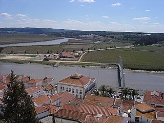
The river Sado is a river in southern Portugal; it is one of the major rivers in the country. It flows in a northerly direction through 175 kilometres (109 mi) from its springs in the hills of Ourique before entering the Atlantic Ocean in an estuary in the city of Setúbal.
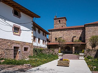
Lantz is a town and municipality located in the province and autonomous community of Navarre, in the North of Spain.

Yesa is a town and municipality located in the province and autonomous community of Navarre, in Northern Spain.
Tranquil Creek Provincial Park is a provincial park in British Columbia, Canada, located at the head of the Kennedy River, east of the head of Bedwell Sound on Vancouver Island.

Walker Air Force Base is a closed United States Air Force base located three miles (5 km) south of the central business district of Roswell, New Mexico. It was opened in 1941 as an Army Air Corps flying school and was active during World War II and the postwar era as Roswell Army Air Field (RAAF). During the early years of the Cold War, it became the largest base of the Strategic Air Command. It is also known for the Roswell UFO incident, an event that occurred on 4 July 1947. It is alleged that a "flying disc" crashed during a severe thunderstorm near the base at Corona, New Mexico.
Collier Mountain is a mountain in the Ridge and Valley region of the Appalachian Mountains, located in Allegany County, Maryland. The 1,457 feet (444 m) ridge is approximately 5 miles (8.0 km) southeast of Cumberland. It runs 6 miles (9.7 km) northeast from the North Branch Potomac River near its confluence with Patterson Creek to Murley Branch south of Breakneck Hill.
Achterdijk is a hamlet in the Dutch province of North Brabant. It is located in the municipality of Moerdijk, about 2 km northeast of the town of Zevenbergen.

Ibaiondo is the fifth district of the city of Bilbao (Biscay), in the Spanish Basque Country. Ibaiondo is a recently used name that means 'beside the river' in Basque. It is divided into the neighbourhoods of Atxuri, Bilbo Zarra, Casco Viejo, Iturralde, Abusu, San Adrián, San Francisco, Solokoetxe, Miribilla and Zabala.
The Atengo River, also known as the Chapalagana River, is a river of Mexico. It is a tributary of the Huaynamota River in the southern Sierra Madre Occidental. Its basin is bounded on the east by the Sierra los Huicholes.

Itarema is a municipality in the state of Ceará in the Northeast region of Brazil.

The 579th Strategic Missile Squadron is an inactive United States Air Force unit. It was last assigned to the 6th Strategic Aerospace Wing at Walker Air Force Base, New Mexico
Greenfield Township is one of the sixteen townships of Warren County, Iowa, United States. Its estimated population as of 2008 is 5,773 people, with a density of 138 people per square mile. Three cities have land in Greenfield, as well as two unincorporated areas. The township has two cemeteries.
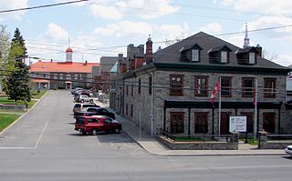
L'Orignal is a Franco-Ontarian village and former municipality, now part of Champlain Township in eastern Ontario, Canada. Its population in 2016 was 1,450. L'Orignal likely took its name from its location on the Ottawa River once known as Pointe à l'Orignal, where moose crossed the river. It was one of the seigneuries of New France.

Black Creek of Arizona is a 55-mi (89 km) long north tributary of the Puerco River, in northeast Arizona and northwest New Mexico.
Badazoui is an arrondissement in the Mono department of Benin. It is an administrative division under the jurisdiction of the commune of Bopa. According to the population census conducted by the Institut National de la Statistique Benin on February 15, 2002, the arrondissement had a total population of 12,362.

Amposta is an administrative neighborhood (barrio) of Madrid belonging to the district of San Blas-Canillejas.
Coyote Wash is a tributary stream of the Chaco River, on the Navajo Nation in San Juan County and McKinley County, New Mexico. Its mouth is located at the turn of the Great Bend of the Chaco River at an elevation of 5,476 feet / 1,669 meters in San Juan County. Its source is at 35°46′57″N108°37′10″W, at the confluence of the streams of Window Rock Canyon and Coyote Canyon at an elevation of 6,080 feet.
Tick Creek is a tributary of the Gasconade River in northwestern Phelps County in the Ozarks of Missouri.
References
- Atlas of Mexico, 1975 (http://www.lib.utexas.edu/maps/atlas_mexico/river_basins.jpg)%5B%5D.
- The Prentice Hall American World Atlas, 1984.
- Rand McNally, The New International Atlas, 1993.
%5B%5D)
20°55′24″N104°37′10″W / 20.92333°N 104.61944°W
| | This article related to a river in Mexico is a stub. You can help Wikipedia by expanding it. |