Slovenia, officially the Republic of Slovenia, is a sovereign state located in southern Central Europe at a crossroads of important European cultural and trade routes. It is bordered by Italy to the west, Austria to the north, Hungary to the northeast, Croatia to the southeast, and the Adriatic Sea to the southwest. It covers 20,273 square kilometers (7,827 sq mi) and has a population of 2.07 million. One of the successor states of the former Yugoslavia, Slovenia is a parliamentary republic and a member of the United Nations, of the European Union, and of NATO. The capital and largest city is Ljubljana.
The history of Slovenia chronicles the period of the Slovenian territory from the 5th century BC to the present. In the Early Bronze Age, Proto-Illyrian tribes settled an area stretching from present-day Albania to the city of Trieste. Slovenian territory was part of the Roman Empire, and it was devastated by Barbarian incursions in late Antiquity and Early Middle Ages, since the main route from the Pannonian plain to Italy ran through present-day Slovenia. Alpine Slavs, ancestors of modern-day Slovenians, settled the area in the late 6th Century A.D. The Holy Roman Empire controlled the land for nearly 1,000 years, and between the mid 14th century and 1918 most of Slovenia was under Habsburg rule. In 1918, Slovenes formed Yugoslavia along with Serbs and Croats, while a minority came under Italy. The state of Slovenia was created in 1945 as part of federal Yugoslavia. Slovenia gained its independence from Yugoslavia in June 1991, and is today a member of the European Union and NATO.
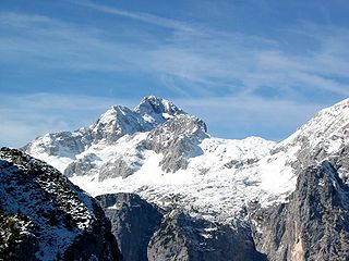
Triglav, with an elevation of 2,863.65 metres (9,395.2 ft), is the highest mountain in Slovenia and the highest peak of the Julian Alps. The mountain is the pre-eminent symbol of the Slovene Nation. It is the centrepiece of Triglav National Park, Slovenia's only national park. Triglav was also the highest peak in Yugoslavia before Slovenia's independence in 1991.
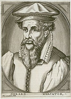
Gerardus Mercator was a 16th-century Southern Dutch cartographer, geographer and cosmographer. He was renowned for creating the 1569 world map based on a new projection which represented sailing courses of constant bearing as straight lines—an innovation that is still employed in nautical charts.

Vipava is a town in western Slovenia. It is the largest settlement and the seat of the Municipality of Vipava. Vipava is located near the numerous sources of the Vipava River, in the upper Vipava Valley, 102 metres (335 ft) above sea level. Historically, it used to be a part of the traditional region of Inner Carniola, but it is now generally regarded as part of the Slovenian Littoral.
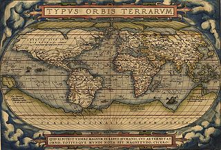
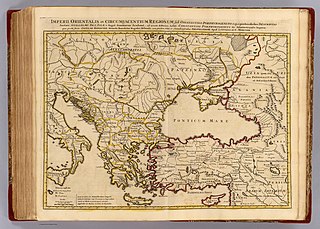
Theatrum Orbis Terrarum is considered to be the first true modern atlas. Written by Abraham Ortelius, strongly encouraged by Gillis Hooftman and originally printed on May 20, 1570, in Antwerp, it consisted of a collection of uniform map sheets and sustaining text bound to form a book for which copper printing plates were specifically engraved. The Ortelius atlas is sometimes referred to as the summary of sixteenth-century cartography. The publication of the Theatrum Orbis Terrarum (1570) is often considered as the official beginning of the Golden Age of Netherlandish cartography.
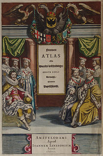
Johannes Janssonius was a Dutch cartographer and publisher who lived and worked in Amsterdam in the 17th century.
The Slovenes, also known as Slovenians, are a nation and South Slavic ethnic group native to Slovenia, and also to Italy, Austria and Hungary in addition to having a diaspora throughout the world. Slovenes share a common ancestry, culture, history and speak Slovene as their native language.
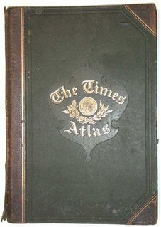
The Times Atlas of the World, rebranded The Times Atlas of the World: Comprehensive Edition in its 11th edition and The Times Comprehensive Atlas of the World from its 12th edition, is a world atlas currently published by HarperCollins Publisher L.L.C. Its most recent edition, the fourteenth, was published on 25 September 2014.
Gaj's Latin alphabet is the form of the Latin script used in Serbo-Croatian and all of its standard varieties: Bosnian, Croatian, Serbian, and Montenegrin. It was devised by Croatian linguist Ljudevit Gaj in 1835, based on Jan Hus's Czech alphabet. A slightly reduced version is used as the script of the Slovene language, and a slightly expanded version is used as a script of the modern standard Montenegrin language. A modified version is used for the romanization of the Macedonian language. Pavao Ritter Vitezović had proposed an idea for the orthography of the Croatian language, stating that every sound should have only one letter. Gaj's alphabet is currently used in Bosnia and Herzegovina, Croatia, Montenegro, and Serbia.

United Slovenia is the name of an unrealized political programme of the Slovene national movement, formulated during the Spring of Nations in 1848. The programme demanded (a) unification of all the Slovene-inhabited areas into one single kingdom under the rule of the Austrian Empire, (b) equal rights of the Slovene language in public, and (c) strongly opposed the planned integration of the Habsburg Monarchy with the German Confederation. The programme failed to meet its main objectives, but it remained the common political program of all currents within the Slovene national movement until World War I.
Prekmurje Slovene, also known as the Prekmurje dialect, East Slovene, or Wendish, is a Slovene dialect belonging to a Pannonian dialect group of Slovene. It is used in private communication, liturgy, and publications by authors from Prekmurje. It is spoken in the Prekmurje region of Slovenia and by the Hungarian Slovenes in Vas County in western Hungary. It is closely related to other Slovene dialects in neighboring Slovene Styria, as well as to Kajkavian with which it retains partial mutual intelligibility and forms a dialect continuum with other South Slavic languages.
Argentines of Slovene descent, also Slovene Argentines or Argentine Slovenes are the Slovenes residing in Argentina. According to Jernej Zupančič of the Slovenian Academy of Sciences and Arts, they number around 30,000.

Planina is a village in the Municipality of Postojna in the Inner Carniola region of Slovenia. It includes the hamlets of Gornja Planina, Dolnja Planina, and Grič in the main settlement as well as Kačja Vas to the southwest and Malni and Hasberg to the south.

Snežnik is a wide karst limestone plateau with an area of about 85 km2 (33 sq mi) in the Dinaric Alps of Slovenia. It mainly consists of Cretaceous limestone, with Jurassic limestone and a small amount of dolomite at the top. The surface was transformed by ice in the last glacial period. It is generally level, but has numerous dry valleys, sinkholes, about 300 caves and shafts, and cold-air pools with temperatures reaching −32 °C (−26 °F) in the coldest part of year. The surface is mainly stony, covered with patchy and shallow soil, except for the larger depressions. Because the plateau is only 28 km (17 mi) from the Adriatic Sea, it has up to 3,000 millimetres (120 in) of precipitation per year. It is covered by snow in winter. Due to the karst nature of the plateau, there are no surface streams.
Contributions to the Slovenian National Program, also known as Nova revija 57 or 57th edition of Nova revija was a special issue of the Slovenian opposition intellectual journal Nova revija, published in January 1987. It contained 16 articles by non-Communist and anti-Communist dissidents in the Socialist Republic of Slovenia, discussing the possibilities and conditions for the democratization of Slovenia and the achievement of full sovereignty. It was issued as a reaction to the Memorandum of the Serbian Academy of Sciences and Arts and to the rising centralist aspirations within the Communist Party of Yugoslavia.

Škocjan Caves is a cave system in Slovenia. Due to its exceptional significance, Škocjan Caves was entered on UNESCO’s list of natural and cultural world heritage sites in 1986. International scientific circles have thus acknowledged the importance of the caves as one of the natural treasures of planet Earth. Ranking among the most important caves in the world, Škocjan Caves represents the most significant underground phenomena both on the Karst Plateau and in Slovenia. Following independence from Yugoslavia in 1991, Slovenia committed itself to actively protecting the Škocjan Caves area and established Škocjan Caves Regional Park and its managing authority, the Škocjan Caves Park Public Service Agency.

Škofja Loka is a town in Slovenia. It is the economic, cultural, educational, and administrative centre of the Municipality of Škofja Loka in Upper Carniola. It has about 12,000 inhabitants.