The Main is the longest tributary of the Rhine. It rises as the White Main in the Fichtel Mountains of northeastern Bavaria and flows west through central Germany for 525 kilometres (326 mi) to meet the Rhine below Rüsselsheim, Hesse. The cities of Mainz and Wiesbaden are close to the confluence.

Hesse or Hessia, officially the State of Hesse, is a state in Germany. Its capital city is Wiesbaden, and the largest urban area is Frankfurt, which is also the country's principal financial centre. Two other major historic cities are Darmstadt and Kassel. With an area of 21,114.73 square kilometers and a population of over six million, it ranks seventh and fifth, respectively, among the sixteen German states. Frankfurt Rhine-Main, Germany's second-largest metropolitan area, is mainly located in Hesse.

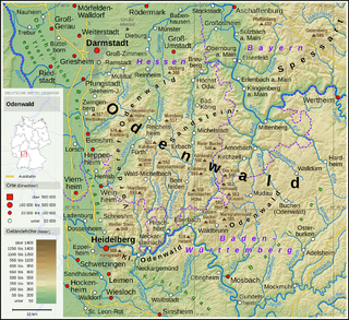
The Odenwald is a low mountain range in the German states of Hesse, Bavaria and Baden-Württemberg.

The Lahn is a 245.6-kilometre-long (152.6 mi), right tributary of the Rhine in Germany. Its course passes through the federal states of North Rhine-Westphalia (23.0 km), Hesse (165.6 km), and Rhineland-Palatinate (57.0 km).

The Rhön Mountains are a group of low mountains in central Germany, located around the border area where the states of Hesse, Bavaria and Thuringia come together. These mountains, which are at the extreme southeast end of the East Hesse Highlands, are partly a result of ancient volcanic activity. They are separated from the Vogelsberg Mountains by the river Fulda and its valley. The highest mountain in the Rhön is the Wasserkuppe, which is in Hesse. The Rhön Mountains are a popular tourist destination and walking area.

Babenhausen is a town in the Darmstadt-Dieburg district, in Hesse, Germany.

Oberaula is a municipality in the Schwalm-Eder district in Hesse, Germany.

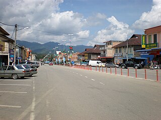
Pengkalan Hulu, formerly known as Kroh or Keroh, is a town and a mukim in Hulu Perak District, Perak, Malaysia, bordering Thailand and Kedah. The nearest town on the Thailand side is Betong in Yala province.

Herleshausen is a municipality in the Werra-Meißner-Kreis in Hesse, Germany.

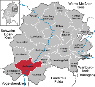
Niederaula is a market community in Hersfeld-Rotenburg district in northeastern Hesse, Germany, 59 km south of Kassel.
Ibra is a city in the Ash Sharquiyah Region of Oman.

The West Hesse Highlands, also known as the West Hessian Lowlands and Highlands, are a heavily forested region of the Central Uplands in Germany. These highlands lie mainly within the state of Hesse, between that part of the Rhenish Massif right of the Rhine in the west, the Weser Uplands to the north, the Hessian Central Uplands to the east and the Wetterau to the south.

The Rimberg in the Knüll Mountains (Knüll) is 1,942 ft above sea level. A massive mountain near in the Hersfeld-Rotenburg district in northern Hesse Germany.

The Kahl is a river in the northern Spessart in Bavaria and Hesse, Germany. It is a right tributary of the Main and is 35.6 km (22.1 mi) long. The name Kahl comes from the Old High German word kaldaha, which means cool and clear. The Kahl rises from two sources left and right of the road at the foot of the Spessart hills, near Kleinkahl. These springs produce 50–60 litres per second. The Kahl flows into the river Main in Kahl am Main. The mouth is near the old Kahl Nuclear Power Plant. The largest tributaries are Westerbach, Sommerkahl, Reichenbach and Geiselbach.

Gersprenz is a river that starts in the Odenwald, Hesse and flows into the river Main near Aschaffenburg, Bavaria, Germany. Including its source river Mergbach, it is 62.1 km (38.6 mi) long, without the Mergbach it is 51.3 km (31.9 mi) long.

The Aar is a river of Hesse, Germany. It flows for 20.6 kilometres (12.8 mi) into the Dill near Herborn.

The Grenff, also Grenf, is a 22 km long, right-bank or southeasterly tributary of the Schwalm. It passes through the East Hesse Highlands in North Hesse Schwalm-Eder-Kreis, and belongs to the river system and catchment area of the Weser.
Ibra is a small river of Hesse, Germany. It flows into the Aula in Kirchheim.


