
The A41 is a major trunk road in England that links London and Birkenhead, although it has now in parts been superseded by motorways. It passes through or near various towns and cities including Watford, Kings Langley, Hemel Hempstead, Aylesbury, Solihull, Birmingham, West Bromwich, Wolverhampton, Newport, Whitchurch, Chester and Ellesmere Port.

The A57 is a major road in England. It runs east from Liverpool to Lincoln, via Warrington, Cadishead, Irlam, Patricroft, Eccles, Salford and Manchester, then through the Pennines over the Snake Pass, around the Ladybower Reservoir, through Sheffield and past Worksop. Within Manchester a short stretch becomes the A57(M) motorway.

The A15 is a major road in England. It runs north from Peterborough via Market Deeping, Bourne, Sleaford and Lincoln along a variety of ancient, Roman, and Turnpike alignments before it is interrupted at its junction with the M180 near Scawby. The road restarts 10 miles (16 km) east, and then continues north past Barton-upon-Humber, crossing the Humber on the Humber Bridge before terminating at Hessle near Kingston upon Hull.

The A24 is a major road in England that runs for 53.2 miles (85.6 km) from Clapham in south-west London to Worthing on the English Channel in West Sussex via the suburbs of south-west London, as well as through the counties of Surrey and West Sussex.

The A52 is a major road in the East Midlands, England. It runs east from a junction with the A53 at Newcastle-under-Lyme near Stoke-on-Trent via Ashbourne, Derby, Stapleford, Nottingham, West Bridgford, Bingham, Grantham, Boston and Skegness to the east Lincolnshire coast at Mablethorpe. It is approximately 147 miles (237 km) long.

The A453 road was formerly the main trunk road connecting the English cities of Nottingham and Birmingham. However, the middle section of this mainly single-carriageway road has largely been downgraded to B roads or unclassified roads following the construction of the parallel M42-A42 link around 1990. The M42 was originally meant to pass further north than it does, and to join the M1 at Sandiacre in Derbyshire. The M42/A42 does not enter Derbyshire, but instead joins the M1 closer to the A453 junction at Kegworth. The A42 shadows the former A453 from Appleby Magna to Castle Donington. The road historically connected the East Midlands with the West Midlands.
The A17 road is a road linking Newark-on-Trent in Nottinghamshire, England, to King's Lynn in Norfolk. It stretches for a distance of 62 miles travelling across the flat Fen landscapes of southern Lincolnshire and western Norfolk.
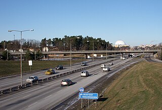
Swedish national road 73, Nynäsvägen, is a Swedish national road in Sweden between Stockholm and Nynäshamn. The length is 57 km (35 mi).

The A638 is a main road in England that runs between the A1 at Markham Moor in Nottinghamshire and Chain Bar Junction 26 of the M62 motorway south of Bradford in West Yorkshire.

The A616 is a road that links Newark-on-Trent, Nottinghamshire, to the M1 motorway at Junction 30, then reappears at Junction 35A and goes on to Huddersfield, West Yorkshire.

The A26 is a road in Northern Ireland. It travels in a North-South direction from Coleraine, County Londonderry to Banbridge, County Down.

The A148 is an English A road entirely in the county of Norfolk. It runs from King's Lynn to Cromer via Fakenham, which it bypasses to the north.
The A631 is a road running from Sheffield, South Yorkshire to Louth, Lincolnshire in England. It passes through the counties of South Yorkshire, Nottinghamshire and Lincolnshire. The road has many towns on its route including Rotherham, Maltby, Gainsborough and Market Rasen. It is mostly single road throughout its length but has some stretches of dual carriageway as well. The road is approximately 65 miles (105 km) long.

The R421 road is a regional road in Ireland which runs southwest-northeast from the R445 south of Roscrea to the N52 north of Tullamore. The route passes through the following towns and villages Roscrea, Clareen, Kinnitty, Killurin and Tullamore. The bulk of the route is in County Offaly with small sections in counties Tipperary and Laois.
The A6121 is a short cross-country road in the counties of Lincolnshire and Rutland, England. It forms the principal route between Bourne and Stamford and the A1 in Lincolnshire, continuing on through Ketton in Rutland to its junction with the A47 at Morcott. Its south-western end is at 52°35.5860′N 0°38.0820′W and its north-eastern end is at 52°45.9120′N 0°24.0660′W. The road has increased in importance with the rapid expansion of housing in this part of South Kesteven.

The R825 road is a regional road in south Dublin, Republic of Ireland. The road starts in Clonskeagh at the junction with the R117 and passes through Goatstown, Kilmacud and Stillorgan before ending at a junction with the N31 in Blackrock, County Dublin. The route is 7.6 km (4.7 mi) in length and is single carriageway apart from a small 2 lane section beside the N11.

U.S. Highway 136 is a part of the United States Numbered Highway System that runs for 804 miles (1,294 km) between Edison, Nebraska and Speedway, Indiana. It is a spur route of US 36 despite never intersecting its parent. Within the State of Nebraska it is a state highway that begins at a junction with US 6 and US 34 north of Edison and travels east across the southern part of the state to the Nebraska–Missouri state line in Brownville along the banks of the Missouri River. Throughout its 239.88-mile (386.05 km) length, the highway is known as the Heritage Highway, one of nine scenic byways in the state. The highway travels across the grassland prairies of southern Nebraska to the woods of the Missouri River Valley encountering winding rivers, farmlands, and historic settlements. These landscapes were featured in stories from Pulitzer Prize-winning author Willa Cather recounting life on the Nebraska Plains during the end of the 19th century. For its entire length, US 136 is a two-lane highway with the exception of a 0.51-mile (0.82 km) stretch of divided highway within Fairbury.

The B52 road connects the A4 road in the village of Belcoo in County Fermanagh above the village green overlooking the shores of Lough MacNean. The road crosses the dismantled Sligo, Leitrim and Northern Counties Railway with the former station and closed level crossing. On leaving Belcoo the road heads westwards to Holywell with the shore of Lough MacNean on the left over the fields. The road continues to Garrison, County Fermanagh, connecting with the B53 and onwards to Drumlisaleen and connecting at Corry Cross Roads with the A46 road in Belleek, County Fermanagh on the border of County Donegal and County Fermanagh. Corry Cross Roads which is in Belleek is the most westerly numbered road junction in the UK.


