
County Fermanagh is one of the thirty-two counties of Ireland, one of the nine counties of Ulster and one of six counties of Northern Ireland.

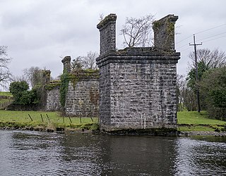
Lough Erne is the name of two connected lakes in County Fermanagh, Northern Ireland. It is the second-biggest lake system in Northern Ireland and Ulster, and the fourth biggest in Ireland. The lakes are widened sections of the River Erne, which flows north and then curves west into the Atlantic. The smaller southern lake is called the Upper Lough as it is higher up the river. The bigger northern lake is called the Lower Lough or Broad Lough. The town of Enniskillen lies on the short stretch of river between the lakes. The lake has more than 150 islands, along with many coves and inlets. The River Erne is 80 miles (129 km) long and drains an area of about 1,680 square miles (4,350 km2).
The N3 road is a national primary road in the Republic of Ireland, running between Dublin, Cavan and the border with County Fermanagh. The A509 and A46 roads in Northern Ireland form part of an overall route connecting to Enniskillen, and northwest to the border again where the N3 reappears to serve Ballyshannon in County Donegal.
The Sligo, Leitrim and Northern Counties Railway (SL&NCR) was a 5 ft 3 in railway in counties Cavan, Fermanagh, Leitrim and Sligo in north-west Ireland. It consisted of one main line, with no branch lines and remained privately owned until its closure.

Belleek is a large village and civil parish in County Fermanagh, Northern Ireland. While the greater part of the village lies within County Fermanagh, part of it crosses the border and the River Erne into County Donegal. It lies in the historic barony of Lurg. It had a population of 904 people in the 2011 Census, and is situated within Fermanagh and Omagh district, around 7 kilometres (4 mi) east of Ballyshannon.

The River Erne in the northwest of the island of Ireland, is the second-longest river in Ulster, flowing through Northern Ireland and the Republic of Ireland, and forming part of their border.
Pettigo, also spelt Pettigoe, is a small village and townland on the border of County Donegal, Republic of Ireland, and County Fermanagh, Northern Ireland. It is bisected by the Termon River which is part of the border between the Republic of Ireland and Northern Ireland.

Garrison is a village near Lough Melvin in County Fermanagh, Northern Ireland. The Roogagh River runs through the village. In the 2021 census it had a population of 411 people. It is situated within Fermanagh and Omagh district.

Kesh is a village in County Fermanagh, Northern Ireland. It is on the Kesh River about 1 mile (1.6 km) from Lower Lough Erne. The 2011 Census recorded a population of 1,039 people. It is within Fermanagh and Omagh district.
Blaney is a small village and townland in County Fermanagh, Northern Ireland. It lies on the southern shore of Lower Lough Erne, 14 km (8.7 mi) west of Enniskillen. It is situated within Fermanagh and Omagh district.

Boa Island is an island near the north shore of Lower Lough Erne in County Fermanagh, Northern Ireland. It is 16 mi (26 km) from Enniskillen town.

White Island is an island in Lower Lough Erne, County Fermanagh, Northern Ireland. It is situated in Castle Archdale Bay off the east shore of Lower Lough Erne. The ruins of an ancient church are found near the shore, built on the site of an earlier monastic settlement. It still has an intact arched Romanesque doorway. The Church and carved figures are State Care Historic Monuments sited in the townland of White Island, in Fermanagh and Omagh District Council area, at grid ref: H1753 6000. The rath, earthwork, and area surrounding the state care monument are Scheduled Historic Monuments, at grid ref: H1753 6000. The island is accessed by ferry from the marina in Castle Archdale Country Park, near Irvinestown. Location: OpenStreetMap Reference
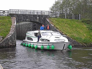
The Shannon–Erne Waterway is a canal linking the River Shannon in the Republic of Ireland with the River Erne in Northern Ireland. Managed by Waterways Ireland, the canal is 63 km (39 mi) in length, has sixteen locks and runs from Leitrim village in County Leitrim to Upper Lough Erne in County Fermanagh.

The A46 is a road in County Fermanagh, in Northern Ireland. It forms part of the route from Dublin to Ballyshannon. It stretches 23.6 miles from Enniskillen to Belleek along the southwestern shoreline of Lower Lough Erne.

The Cuilcagh Lakelands Geopark formerly known as the Marble Arch Caves Global Geopark straddles the border between Northern Ireland and the Republic of Ireland. It is centred on the Marble Arch Caves and in 2001 it became one of the first geoparks to be designated in Europe.

Magheraboy is a barony in County Fermanagh, Northern Ireland. To its east lies Lower Lough Erne, and it is bordered by three other baronies in Northern Ireland: Lurg to the north; Tirkennedy to the east; and Clanawley to the south It also borders two baronies in the Republic of Ireland: Tirhugh to the north; and Rosclogher to the south. The westernmost point of Magheraboy is also the westernmost point of Northern Ireland..

Lurg is a barony situated in the north of County Fermanagh, Northern Ireland. To its south lies Lower Lough Erne, and it is bordered by four other baronies in Northern Ireland: Magheraboy to the south; Tirkennedy to the south-east; Omagh West to the north; and Omagh East to the east. It also borders to the west the barony of Tirhugh in the Republic of Ireland.
The Enniskillen and Bundoran Railway (E&BR) was an Irish gauge 5 ft 3 in railway company in north-west Ireland. It linked Bundoran and Ballyshannon on the Atlantic coast of Donegal with the Londonderry and Enniskillen Railway (L&ER) at Bundoran Junction in Fermanagh. The line was opened in 1868 and closed in 1957.
The Tyrone Group is a lithostratigraphical term coined to refer to a particular succession of rock strata which occur in Northern Ireland within the Visean Stage of the Carboniferous Period. It comprises a series of limestones, shales and sandstones which accumulated to a thickness of 2400m in the northwest Carboniferous basin of Ireland. The type areas for the group are the Clogher Valley of County Tyrone and the Fermanagh Highlands of nearby County Fermanagh. The rocks of the group sit unconformably on older rocks of the Shanmullagh Formation of the Fintona Group which are the local representatives of the Lower Old Red Sandstone. The top of the Dartry Limestone, the uppermost part of the group, is a disconformity, above which are the layered sandstones and shales of the Meenymore Formation of the Leitrim Group. The succession continues south and west across the border into the Republic of Ireland, though different names are typically applied.

The Finn River, also known as the River Finn, is a small river that flows through parts of County Fermanagh and parts of County Monaghan in the south of Ulster, the northern province in Ireland. In certain places, the river forms part of the boundary between County Fermanagh, which is part of Northern Ireland, and County Monaghan, which is part of the Republic of Ireland. Two very short stretches of the river, just north of Redhills and at Castle Saunderson, near Belturbet, also form part of the boundary between County Fermanagh and County Cavan. This means that some stretches of the river form part of the border between Northern Ireland and the Republic of Ireland, these short stretches also forming part of the external border of the European Union.

