This article needs additional citations for verification .(January 2009) |


The A55 road forms Belfast's outer-ring road.
This article needs additional citations for verification .(January 2009) |
The A55 road forms Belfast's outer-ring road.
A55 links many of the main arterial routes within the city as well as creating a bypass of the often congested city centre and problematic A12 Westlink. Large sections of the route in east Belfast have been upgraded to dual carriageway standard with at-grade traffic light controlled junctions, together with off-road cycle paths alongside. However many sections (e.g. through Knock and from the Shaw's Bridge (Belvoir) to the M1) remain single carriageway, with four lanes of traffic. (Though the section through Knock has a proposed upgrade going through the final designs stages as of January 2009.) Despite this, all of the route in the west and north of the city (with the notable exception of the Monagh Bypass near Andersonstown) is nothing more than a single carriageway two-lane road based on local city streets and arterial routes.
The A55 crosses the River Lagan at Lagan Valley Regional Park, where the Malone Road becomes the Milltown Road. The single-span, 70m-long arched concrete bridge runs parallel to the more historic Shaw's Bridge, which it replaced in 1977. [1]
The lack of investment directed towards an upgrade for these sections of the city's ring road can be explained by a lack of demand, relatively lower traffic levels and few industrial sites in comparison to those of the south and east. However, in an attempt to attract inwards investment into the area the West Belfast & Greater Shankill Task Force has laid out a plan (publicised in late 2008) which proposes to extend and improve the route; extending from the Monagh Bypass as far north as the A52 Crumlin Road in the northwest of the city.

The A40 is a trunk road which runs between London and Goodwick (Fishguard), Wales, and officially called The London to Fishguard Trunk Road (A40) in all legal documents and Acts. Much of its length within England has been superseded by motorways, such as the M40, and has lost its trunk road status, though it retains it west of Gloucester, including its length within Wales. It is approximately 260 miles (420 km) long. The eastern section from Denham, Buckinghamshire to Wheatley, Oxfordshire is better served by the M40 and its former function of linking London with Cheltenham and Gloucester has been taken by the M4, A419 and A417 via Swindon.

The A38, parts of which are known as Devon Expressway, Bristol Road and Gloucester Road, is a major A-class trunk road in England.

The N11 road is a national primary road in Ireland, running for 129 km (80 mi) along the east side of Ireland from Dublin to Wexford. It passes close to Bray, Greystones, Wicklow, Arklow, Gorey, and Enniscorthy. Beyond Wexford, the route continues to Rosslare as the N25. The road forms part of European route E01. As of July 2019 the N11/M11 is of dual carriageway or motorway standard from Dublin as far as Oilgate in County Wexford.
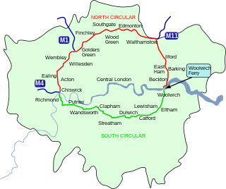
The South Circular Road in south London, England, is a major road that runs from the Woolwich Ferry in the east to the Chiswick Flyover in the west via Eltham, Lee Green, Catford, Forest Hill, Dulwich, Tulse Hill, Clapham Common, Clapham Junction, Wandsworth, Putney, Barnes, Mortlake and Kew Bridge. Together with the North Circular Road and Woolwich Ferry, it makes a complete ring-road around Central London and is a former boundary of the Ultra Low Emission Zone. The South Circular is largely a sequence of urban streets joined together, requiring several at-grade turns, unlike the mostly purpose-made carriageways of the North Circular. As a result, it is frequently congested.

The A27 is a major road in England. It runs from its junction with the A36 at Whiteparish in the county of Wiltshire, follows the south coast of Hampshire and West Sussex, and terminates at Pevensey in East Sussex.

Princes Highway is a major road in Australia, extending from Sydney via Melbourne to Adelaide through the states of New South Wales, Victoria and South Australia. It has a length of 1,941 kilometres (1,206 mi) or 1,898 kilometres (1,179 mi) via the former alignments of the highway, although these routes are slower and connections to the bypassed sections of the original route are poor in many cases.

The A55, also known as the North Wales Expressway, is a major road in Wales and England, connecting Cheshire and North Wales. The vast majority of its length from Chester to Holyhead is a dual carriageway primary route, with the exception of the Britannia Bridge over the Menai Strait and several short sections where there are gaps in between the two carriageways. All junctions are grade separated apart from a roundabout east of Penmaenmawr and another nearby in Llanfairfechan. Initially, the road ran from Chester to Bangor. In 2001, it was extended across Anglesey to the ferry port of Holyhead parallel to the A5. The road improvements have been part funded with European money, under the Trans-European Networks programme, as the route is designated part of Euroroute E22.

The Monash Freeway is a major urban freeway in Victoria, Australia, linking Melbourne's CBD to its south-eastern suburbs and beyond to the Gippsland region. It carries up to 180,000 vehicles per day and is one of Australia's busiest freeways. The entire stretch of the Monash Freeway bears the designation M1.

Calder Highway is a rural highway in Australia, linking Mildura and the Victoria/New South Wales border to Bendigo, in North Central Victoria. South of Bendigo, where the former highway has been upgraded to freeway-standard, Calder Freeway links to Melbourne, subsuming former alignments of Calder Highway; the Victorian Government completed the conversion to freeway standard from Melbourne to Bendigo on 20 April 2009.

Western Highway is a major arterial route in western Victoria with a length of approximately 258 kilometres (160 mi) of single carriageway, then 161 kilometres (100 mi) of dual carriageway known as Western Freeway, linking the western suburbs of Melbourne to the border with South Australia at Serviceton. It is the Victorian part of the principal route linking the Australian cities of Melbourne and Adelaide, and is a part of the National Highway network, designated routes A8 and M8. The western end continues into South Australia as Dukes Highway, the next section of the Melbourne–Adelaide National Highway.
The N25 road is a national primary road in Ireland, forming the route from Cork to Rosslare Europort via Waterford City. The road is part of the E30 European route and a short section is also part of the E01 European route. It forms part of the proposed Atlantic Corridor route.

The A494 is a trunk road in Wales and England. The route, which is officially known as the Dolgellau to South of Birkenhead Trunk Road, runs between the terminus of the M56 motorway between Mollington and Capenhurst and the A470 at Dolgellau, Gwynedd. Its northern sections remain among the busiest roads in Wales.

The Townsville Ring Road is a motorway in Townsville, Queensland, Australia. The road has been constructed as the new A1/M1 route that bypasses the inner metro area of Townsville. The road was built in 5 stages with the first stage, the Douglas Arterial Road, opened in April 2005 and the most recent section opened in October 2023. Stage 5 commenced construction in July 2021 which included the duplication of the remaining 6-kilometre 2-lane undivided section between Vickers Bridge and Shaw Road in Thuringowa. There is no toll for the use of this motorway.
The R136 road is a regional road in Ireland, located in the southwest of Dublin. Named the Outer Ring Road, the route, which is dual carriageway, runs from the N4 at Lucan to the N81 at Tallaght, bypassing west of Clondalkin and crossing the N7 near Citywest. It was built as part of the planning for the new town of Adamstown.

The A6 road in Northern Ireland runs for 71.4 miles (114.9 km) from Belfast to Derry, via County Antrim and County Londonderry. While stretches of the road before Randalstown have now been superseded by a motorway, the A6 remains one of the most important arterial routes in Northern Ireland, connecting its two largest cities and urban areas. Between Randalstown and Derry, the road forms part of European route E16.
Ballarat Road is a major urban arterial road in the western suburbs of Melbourne, Victoria, Australia.
State Highway 74 is a state highway in New Zealand servicing the eastern suburbs of Christchurch. Mostly two-lane, it is composed of limited-access expressways, with part of the highway as the Christchurch-Lyttelton Motorway, and connects the city to its port town of Lyttelton.

Shaw's Bridge is the name given to two adjacent bridges across the River Lagan in Belfast, Northern Ireland. The older of the bridges is a historic stone arched bridge, which is open to cyclists and pedestrians. The new bridge is a concrete bridge which carries the A55 road.
Plenty Road is a major urban arterial road through the north-eastern suburbs of Melbourne, Victoria, Australia, from the inner suburb of Preston to the township of Whittlesea, just outside the north-eastern suburban fringe of Melbourne.
| Motorways |  | |
|---|---|---|
| Main 'A' roads | ||
| Main 'B' roads | ||
| Others | ||