
Derry, officially Londonderry, is the largest city in County Londonderry, the second-largest in Northern Ireland and the fifth-largest on the island of Ireland. The old walled city lies on the west bank of the River Foyle, which is spanned by two road bridges and one footbridge. The city now covers both banks.

Lifford is the county town of County Donegal, Ireland, the administrative centre of the county and the seat of Donegal County Council, although the town of Letterkenny is often mistaken as holding this role.
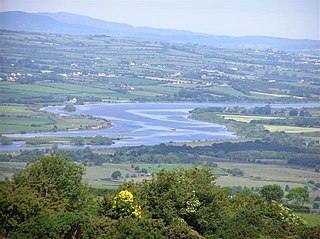
The River Foyle is a river in west Ulster in the northwest of the island of Ireland, which flows from the confluence of the rivers Finn and Mourne at the towns of Lifford in County Donegal, Republic of Ireland, and Strabane in County Tyrone, Northern Ireland. From here it flows to the city of Derry, where it discharges into Lough Foyle and, ultimately, the Atlantic Ocean. The total length of the River Foyle is 32 km (20 mi). The river separates part of County Donegal from parts of both County Londonderry and County Tyrone. The district of County Donegal that borders the western bank of the River Foyle is traditionally known as the Laggan. This district includes the villages of St Johnston and Carrigans, both of which are nestled on the banks of the River.
The N2 road is a national primary road in Ireland, running from Dublin to the border with Northern Ireland at Moy Bridge near Aughnacloy, County Tyrone to connect Dublin with Derry and Letterkenny via the A5. A section of the route near Dublin forms the M2 motorway.

The N13 road is a national primary road in Ireland, running in County Donegal in Ulster from Stranorlar to just outside Derry. This road connects Letterkenny to Sligo, Derry and onwards to other destinations.

The N14 road is a national primary road in the Republic of Ireland. The entirety of the route is located in the northwest of Ireland, in County Donegal, connecting Manorcunningham to Lifford in the east. Here it connects to the N15 near the border with Northern Ireland and along the A38 to Strabane in County Tyrone.

The R236 road runs in County Donegal in Ulster, and links Stranorlar, via Convoy and Raphoe, to St Johnston and Carrigans, becoming the A40 into Derry in Northern Ireland.

Raphoe is a small town in County Donegal in the north-west of Ulster, the northern province in Ireland. It is the main town in the fertile district of East Donegal known as the Laggan. It gave its name to the Barony of Raphoe, which was later divided into the baronies of Raphoe North and Raphoe South, as well as to the Roman Catholic Diocese of Raphoe and the Church of Ireland (Anglican) Diocese of Derry and Raphoe. There is also a civil parish of Raphoe.

The A2 is a major road in Northern Ireland, a considerable length of which is often referred to the Antrim Coast Road because much of it follows the scenic coastline of County Antrim; other parts of the road follow the coasts in Counties Down and Londonderry.
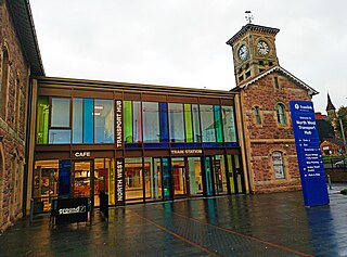
Derry ~ Londonderry railway station, also known as North West Transport Hub or Waterside railway station, is a railway terminus in Derry, Northern Ireland, on the east bank of the River Foyle, operated by Northern Ireland Railways and its 7th busiest station across the network with 952,126 passengers boarding or alighting at the station in the 2023/24 financial year. It is on the Belfast–Derry railway line, terminating at Belfast Grand Central. Derry/Londonderry has the longest platforms on the NIR Network, at 258.3 metres in length.

The Craigavon Bridge is one of three bridges in Derry, Northern Ireland. It crosses the River Foyle further south than the Foyle Bridge and Peace Bridge. It is one of only a few double-decker road bridges in Europe. It was named after Lord Craigavon, the first Prime Minister of Northern Ireland.

The Foyle Bridge is a bridge in Derry, Northern Ireland. The central span of the bridge is the longest on the island of Ireland, at 234 metres (767 ft), and the whole suspended bridge structure including the approach spans is 866 metres long (2839 ft).

The A6 road in Northern Ireland runs for 71.4 miles (114.9 km) from Belfast to Derry, via County Antrim and County Londonderry. While stretches of the road before Randalstown have now been superseded by a motorway, the A6 remains one of the most important arterial routes in Northern Ireland, connecting its two largest cities and urban areas. Between Randalstown and Derry, the road forms part of European route E16.

The A5 is a major primary route in Northern Ireland. It links the city of Derry in County Londonderry with Aughnacloy, County Tyrone via the towns of Strabane and Omagh. Just south of Aughnacloy is the border with the Republic of Ireland, where the A5 meets the N2 to Dublin. Between them the A5 and N2 are the main road link between County Donegal in the Republic and Dublin.

Killea is a village and civil parish on the border of County Donegal, Ireland, and County Londonderry in Northern Ireland.

The Waterside generally refers to the part of Derry/Londonderry on the east bank of the River Foyle. Traditionally, the Waterside ends at the Caw roundabout near the Foyle Bridge. Areas such as Eglinton and Limavady are not part of the Waterside.
Much of the architecture of Letterkenny, the largest town in County Donegal in Ireland, dates from the 19th century. Some examples of older architecture remain in the town – though much has been lost also, through decay and modern development.

St Johnston, officially Saint Johnstown, is a village, townland, and an electoral division in County Donegal, Ireland. It is in the Laggan district of East Donegal on the left bank of the River Foyle. It is in the civil parish of Taughboyne and barony of Raphoe North, on the R236 (Lifford–Newtowncunningham) road where it overlaps the R265 (Carrigans–Raphoe) road. The village is about 12 kilometres (7.5 mi) south of Derry.

Foyle Valley Railway Museum is a museum in Derry, Northern Ireland. It is run by the charity Destined and is dedicated to the history of narrow gauge railways in the surrounding area. A heritage railway named Foyle Valley Railway previously ran from the museum.

The R265 is a regional road in County Donegal, Ireland. It runs north to south from near Newtown Cunningham to Rossgier near Lifford. The road runs from near Lough Swilly and generally along the west bank of the River Foyle. The road runs through mostly arable farmland in the East Donegal area.

