
Letterkenny, nicknamed 'the Cathedral Town', is the largest and most populous town in County Donegal, a county in Ulster, the northern province in Ireland. Letterkenny lies on the River Swilly in East Donegal in the north-west of Ulster, and has a population of 19,274. It is the 36th largest settlement in all of Ireland by population, and is the 15th largest settlement by population in the province of Ulster. Along with the nearby city of Derry, Letterkenny is considered a regional economic gateway for the north-west of Ireland. Letterkenny acts as an urban gateway to the Ulster Gaeltacht, similar to Galway's relationship to the Connemara Gaeltacht.

Lifford is the county town of County Donegal, Ireland, the administrative centre of the county and the seat of Donegal County Council, although the town of Letterkenny is often mistaken as holding this role.
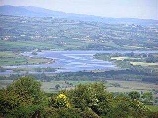
The River Foyle is a river in west Ulster in the northwest of the island of Ireland, which flows from the confluence of the rivers Finn and Mourne at the towns of Lifford in County Donegal, Republic of Ireland, and Strabane in County Tyrone, Northern Ireland. From here it flows to the city of Derry, where it discharges into Lough Foyle and, ultimately, the Atlantic Ocean. The total length of the River Foyle is 32 km (20 mi). The river separates part of County Donegal from parts of both County Londonderry and County Tyrone. The district of County Donegal that borders the western bank of the River Foyle is traditionally known as the Laggan. This district includes the villages of St Johnston and Carrigans, both of which are nestled on the banks of the River.

Stranorlar is a town, townland and civil parish in the Finn Valley of County Donegal, in Ireland. Stranorlar and Ballybofey form the Twin Towns.

The N13 road is a national primary road in Ireland, running in County Donegal in Ulster from Stranorlar to just outside Derry. This road connects Letterkenny to Sligo, Derry and onwards to other destinations.

The N14 road is a national primary road in the Republic of Ireland. The entirety of the route is located in the northwest of Ireland, in County Donegal, connecting Manorcunningham to Lifford in the east. Here it connects to the N15 near the border with Northern Ireland and along the A38 to Strabane in County Tyrone.
The N15 road is a national primary road in the north-west of Ireland. It runs from Sligo to Lifford, County Donegal. It forms part of the proposed Atlantic Corridor route. It also goes to the border with Northern Ireland.

Raphoe is a small town in County Donegal in the north-west of Ulster, the northern province in Ireland. It is the main town in the fertile district of East Donegal known as the Laggan, as well as giving its name to the Barony of Raphoe, which was later divided into the baronies of Raphoe North and Raphoe South, as well as to the Roman Catholic Diocese of Raphoe and the Church of Ireland (Anglican) Diocese of Derry and Raphoe.
Convoy is a village in the east of County Donegal in the north-west of Ulster, the northern province in Ireland. The town is located in the Finn Valley district and is part of the Barony of Raphoe South. It is situated on the Burn Dale, and is located on the R236 road to Raphoe.

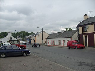
Castlefin, sometimes spelt Castlefinn, is a market town and townland in the Finn Valley of County Donegal in Ulster, the northern province in Ireland. It is located between Ballybofey and Lifford in East Donegal and, as of 2016, the population was 705. The River Finn flows by the town. The town is located in along the main N15 national primary road, which runs from Bundoran to Lifford. The town lies 6 miles from Lifford and 8 miles from the twin towns of Ballybofey and Stranorlar. It has close links to Letterkenny, to the twin towns of Ballybofey and Stranorlar, and to West Tyrone in Northern Ireland, especially with the towns of Strabane and Castlederg.

St Johnston, officially Saint Johnstown, is a village, townland, and an electoral division in County Donegal, Ireland. It is in the Laggan district of East Donegal on the left bank of the River Foyle. It is in the civil parish of Taughboyne and barony of Raphoe North, on the R236 (Lifford–Newtowncunningham) road where it overlaps the R265 (Carrigans–Raphoe) road. The village is about 12 kilometres (7.5 mi) south of Derry.

The N56 road is a national secondary road in the Republic of Ireland that runs from Donegal Town clockwise to Letterkenny. As originally designated, it included the section of the N13 between Stranorlar and Letterkenny, forming a circular route including parts of the N15.

Porthall is a village and townland in County Donegal, Ireland. The village is located on the west bank of the River Foyle, in The Laggan district of East Donegal, on the R265 road. The nearest town is Lifford, the county town.
The High Sheriff of Donegal was the British Crown's judicial representative in County Donegal in Ulster, Ireland, from the late 16th century until 1922, when the office was abolished in the new Irish Free State and replaced by the office of Donegal County Sheriff. The High Sheriff had judicial, electoral, ceremonial and administrative functions and executed High Court Writs. In 1908, an Order in Council made the Lord-Lieutenant the Sovereign's prime representative in a county and reduced the High Sheriff's precedence. However, the sheriff retained his responsibilities for the preservation of law and order in the county. The usual procedure for appointing the sheriff from 1660 onwards was that three persons were nominated at the beginning of each year from the county and the Lord Lieutenant then appointed his choice as High Sheriff for the remainder of the year. Often the other nominees were appointed as under-sheriffs. Sometimes a sheriff did not fulfil his entire term through death or other event and another sheriff was then appointed for the remainder of the year. The dates given hereunder are the dates of appointment. All addresses are in County Donegal unless stated otherwise.

Killygordon is a small village in the Finn Valley in the east of County Donegal in Ulster, the northern province in Ireland. As of 2016, the population was 614. It is located on the N15 between Ballybofey and Castlefin. The separate hamlet and townland of Crossroads, usually known as The Cross, lies half a mile from Killygordon. The River Finn passes by the village on its way towards its confluence with the River Mourne and the River Foyle.

The A40 links Derry in the North West of Northern Ireland to Raphoe in County Donegal.

The R265 is a regional road in County Donegal, Ireland. It runs north to south from near Newtown Cunningham to Rossgier near Lifford. The road runs from near Lough Swilly and generally along the west bank of the River Foyle. The road runs through mostly arable farmland in the East Donegal area.
The R264 road is a regional road in Ireland, located in County Donegal in Ulster. It runs between Raphoe and Lifford. The road passes through the village of Ballindrait, where it crosses over the Burn Dale.

Letterkenny bus station is a Bus Éireann station serving the County of Donegal in Ireland. It is located in the Cathedral Town of Letterkenny. It is a particularly important transport hub in the county, as there are no rail services in the area.
The Burn Dale is a burn or small river in the east of County Donegal in Ulster, the northern province in Ireland. The burn is also known in English as the Dale Burn, the Burn Deele, the Burndale River, the Deele River or the River Deele. In the Ulster Scots dialect, a 'burn' is a stream or small river.

