Killary Harbour or Killary Fjord is a fjord or fjard on the west coast of Ireland, in northern Connemara. To its north is County Mayo and the mountains of Mweelrea and Ben Gorm; to its south is County Galway and the Maumturk Mountains.

The Western Way is a long-distance trail in Ireland. It is 179 kilometres long and begins in Oughterard, County Galway and ends in Ballycastle, County Mayo. It is typically completed in seven days. It is designated as a National Waymarked Trail by the National Trails Office of the Irish Sports Council and is managed by Coillte, Galway County Council, Mayo County Council, South Mayo Development Company and Mayo North & East Development Company.
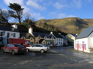
Leenaun, also Leenane, is a village and 1,845 acre townland in County Galway, Ireland, on the southern shore of Killary Harbour and the northern edge of Connemara.
An Mám is a small village and its surrounding lands in Connemara, County Galway, Ireland.

A regional road in the Republic of Ireland is a class of road not forming a major route, but nevertheless forming a link in the national route network. There are over 11,600 kilometres of regional roads. Regional roads are numbered with three-digit route numbers, prefixed by "R". The equivalent road category in Northern Ireland are B roads.

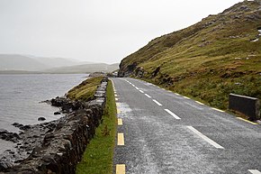
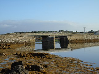
The N59 road is a national secondary road in Ireland. It commences in County Sligo, south of Sligo Town at the Belladrehid interchange with the N4 north of Ballysadare. The route circles around the west of Ireland, passing west from Sligo into County Mayo and through Ballina. The N59 continues around Mayo, proceeding indirectly to Westport. Continuing south through Mayo into County Galway, the road passes through the village of Leenaun. The 182-year-old bridge in the centre of the village, carrying the road across the River Lahill, collapsed in floods on 18 July 2007. Due to the local terrain and road network, the diversionary route for getting from the south of the village to Westport was 110 km long. A temporary bridge was opened eight days after the floods, on 27 July. It has since been replaced by a new bridge.

The R327 road is a regional road in Ireland connecting the N60 east of Claremorris, County Mayo, to the R360 in County Galway.

The N84 road is a national secondary road in Ireland. It is a major route in the West connecting Galway city with Castlebar. The route is of poor quality with a few short good sections in County Mayo between Ballintubber and Ballinrobe. Ballinrobe has become a bottleneck on the route in recent years with up to 8,000 vehicles passing through the town's one-way streets. A bypass for the town is in the planning.
The R374 road is a regional road in County Galway, Ireland.

The R328 road is a regional road in Counties Mayo and Galway in Ireland, connecting Ballindine on the N17 to Moylough on the N63.

The R300 road is a regional road in southwest County Mayo and north County Galway in Ireland. It connects the R330 road at Cloonee and the nearby N84 road at Partry to the R345 road at Clonbur, 36.2 kilometres (22.5 mi) to the south. It passes through the area known as Joyce Country between the Partry Mountains and Lough Mask.
The R345 road is a regional road in north County Galway and southwest County Mayo in Ireland. It connects the R336 road at Maum to the R334 road at Neale, 26.4 kilometres (16.4 mi) to the east. It crosses the winding border between the two counties a number of times.
The R334 road is a regional road in south County Mayo and north County Galway in Ireland. It connects the N84 road at Ballinrobe to the N84 road again at Headford, 20.8 kilometres (12.9 mi) to the south. It passes to the east of Lough Mask and Lough Corrib.

Corcogemore at 609 metres (1,998 ft), is the 208th–highest peak in Ireland on the Arderin scale, and the 253rd–highest peak on the Vandeleur-Lynam scale. Corcogemore is located on a small massif that includes Binn Mhór, and Mullach Glas ; this massif is situated at the far southeastern sector of the long north-west to south-east central spine of the Maumturks mountain range in the Connemara National Park in Galway, Ireland. Corcogemore is the 8th-highest peak in the Maumturks range, and the most southerly in the range; after Lackavrea, Corcogemore is the 2nd-most easterly Maumturk.

The R332 road is a regional road in County Galway and County Mayo in Ireland. It connects the N63 road at Horseleap Cross near Moylough in County Galway, via Tuam, to the N84 road at Kilmaine in County Mayo, 38 kilometres (24 mi) away.

The R378 road is a regional road in County Mayo in Ireland. It runs along the south shore of Clew Bay and connects the R335 in Louisburgh to Roonagh Quay, 7.2 kilometres (4.5 mi) away.
Gleann an Mháma is a glacial valley in County Galway, Ireland. It lies within Joyce Country in Connemara and is part of an aspirant geopark. Much of the valley is in the Connemara Gaeltacht.

Leenaun Hill at 618 metres (2,028 ft), is the 201st–highest peak in Ireland on the Arderin scale, and the 243rd–highest peak on the Vandeleur-Lynam scale. Leenaun Hill lies on a massif that overlooks Leenaun village and Killary Harbour, and which is at the far northeastern sector of the Maumturks mountain range in the Connemara National Park in Galway, Ireland; this massif is connected to the main range via the "Col of Despondency". Leenaun Hill is the 6th-highest mountain in the Maumturks, and its grassy massif, constructed from sandstone and siltstone, contrasts with the rocky ridges and summits constructed from quartzites, grits, and graphitic, of the middle and southern sectors of the range.
Finny is a small village and townland in County Mayo, Ireland. The village is situated in the civil parish of Ross, in the Barony of Ross. Finny is located on the R300 regional road. The nearby Finny River, rising from the south-east of Loch Na Fooey drains westward into the southwest part of Lough Mask. Finny is approximately 10 km to the west of Clonbur, County Galway, 11 km to the east of Leenaun, County Galway and 17 km south west of Toormakeady, County Mayo.