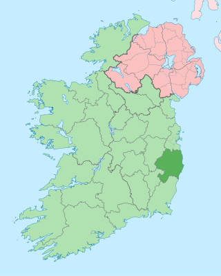
County Wicklow is a county in Ireland. The last of the traditional 32 counties, having been formed as late as 1606, it is part of the Eastern and Midland Region and the province of Leinster. It is bordered by the Irish Sea to the east and the counties of Wexford to the south, Carlow to the southwest, Kildare to the west, and South Dublin and Dún Laoghaire–Rathdown to the north.

The N81 road is a national secondary road in Ireland, from the M50 motorway to Tullow, County Carlow, north to south. The N81 continues past Tullow for another 8 km to terminate at the village of Closh, County Carlow, where it intersects the N80. The N81 is 76.784 km (47.711 mi) long. The road is a dual carriageway between M50 motorway and west of Tallaght, known as the Tallaght Bypass or Blessington Road. It intersects with the M50 motorway at Junction 11. There are plans to extend the dual carriageway by 5 km (3.1 mi) to the urban boundary.

Newtownmountkennedy is a small town in County Wicklow, Ireland. It developed within the historic townland of Ballygarny, although all that remains is a motte where a church, graveyard and a castle or tower house once stood just 0.85 km (0.53 mi) north of the town. It acquired its present name in the mid-seventeenth-century, when Sir Robert Kennedy, M.P. for Kildare, made it his principal residence. It is just off the N11 road to Wexford, just south of Kilpedder and south-west of Greystones. It is about 15 km (9.3 mi) north of Wicklow town, 15 km (9.3 mi) south of Bray and approximately 35 km (22 mi) from Dublin. The R772 regional road passes through the village. This was the main Dublin-Wexford route, the N11, but the village was bypassed by the new N11 dual carriageway in 1990. This town has one of the longest place names in Ireland.

Brittas Bay in County Wicklow, Ireland is a 4 kilometres (2.5 mi) stretch of beach on the Irish Sea coast, about 12 kilometres (7.5 mi) south of Wicklow. The beach and associated dunes are very popular with Dubliners and are one of the most frequented beaches by residents of the capital during the summer.

The R752 road is a regional road in County Wicklow, Ireland. From its junction with the R772 in Rathnew on the outskirts of Wicklow Town it takes a generally south-westerly route to its junction with the R747 in the village of Woodenbridge, where it terminates. The road is 26 km (16 mi) long.

Ashford, historically known as Ballymacahara, is a village in County Wicklow, Ireland. It lies on the River Vartry and at the meeting of the R772, R763 and R764 regional roads. The village was formerly on the main Dublin–Wexford route, the N11, but was bypassed by the new N11 in 2004. As of the 2022 census, the village had a population of 1,892 people.

The R115 road is a regional road in counties Dublin and Wicklow in Ireland. It follows the Military Road for its entire length. The R115 is 40.5 km (25.2 mi) long; the full length of the Military Road is 57.9 km (36.0 mi).

The R756 road is a regional road in Ireland running west–east from Dunlavin to Laragh. Its entire 32 km (20 mi) length is within County Wicklow crossing east–west through the Wicklow Gap.
The R755 road is a regional road in Ireland. It runs for its entire length in County Wicklow. From the village of Kilmacanogue on the N11 national primary road it goes north/south for 36 km (22 mi) to the town of Rathdrum.

The R747 road is a regional road in Ireland running north-west/south-east from the M9 near Ballitore in County Kildare to Arklow in County Wicklow, a distance of 66 km (41 mi).
The R772 road is a regional road in Ireland which comprises disconnected sections of road which once formed part of the N11 but which have now been by-passed, joined by some new road sections and some former local roads.

The R117 road is a regional road in Ireland. The route (north-south) starts Harcourt Road at the end of the South Circular Road on the southside of Dublin city centre. It crosses the Grand Canal and goes through the suburbs of Ranelagh, Milltown, Windy Arbour, Dundrum, Sandyford, Stepaside and Kilternan before passing through the Scalp into County Wicklow.

The R761 road is a regional road in County Wicklow in Ireland. From its junction with the M11 and R119 in Bray it takes a southerly route to its junction with the R750 in the village of Rathnew, on the outskirts of Wicklow, where it terminates.

The R725 road is a regional road in Ireland. From its junction with the N80 on the western outskirts of Carlow Town it takes an easterly route to its junction with the N81 in Tullow, where it crosses the River Slaney on a bridge shared with the N81 in the town centre. It continues east to Shillelagh in County Wicklow, turns due south for 6 km, then eastwards through Carnew. It then enters County Wexford for the final 15 km stretch, terminating in Gorey at the R772. The road is 53 km (33 mi) long.

The R741 road is a regional road in County Wexford, Ireland. From its junction with the R772 in Gorey it takes a southerly route to its junction with the R730 in the centre of Wexford Town, where it terminates.

European route E1 is a series of roads in Europe, part of the United Nations International E-road network, running from Larne, Northern Ireland to Seville, Spain. There is a sea crossing between Rosslare Harbour, in Ireland, and Ferrol, but no ferry service. The road also passes through Portugal – past the city of Porto, through the capital, Lisbon, and then south to the Algarve, passing Faro before reaching the Spanish border west of Huelva.

The R764 road is a regional road in Ireland joining the villages of Roundwood and Ashford in County Wicklow.

The R765 road is a regional road in Ireland joining the villages of Roundwood and Newtownmountkennedy in County Wicklow.

The R114 road is a regional road in south Dublin, Ireland. The road runs from the city centre to Brittas in remote southwest County Dublin via Rathmines, Rathgar, Rathfarnham, Knocklyon, Firhouse and the mountainous area of Boharnabreena. The final stretch of the road runs just north of the border between County Dublin and County Wicklow, parallel to the Brittas River and a canal to the River Camac, which rises just to the north.

The R773 road is a regional road in Ireland. The road connects Jack White's with Brittas Bay and the coast.

