
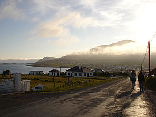
Achill Island is an island off the west coast of Ireland in the historical barony of Burrishoole, County Mayo. It is the largest of the Irish isles and has an area of approximately 148 km2 (57 sq mi). Achill had a population of 2,345 in the 2022 census. The island, which has been connected to the mainland by a bridge since 1887, is served by Michael Davitt Bridge, between the villages of Achill Sound and Polranny. Other centres of population include the villages of Keel, Dooagh, Dooega, Dooniver, and Dugort. There are a number of peat bogs on the island.

County Mayo is a county in Ireland. In the West of Ireland, in the province of Connacht, it is named after the village of Mayo, now generally known as Mayo Abbey. Mayo County Council is the local authority. The population was 137,231 at the 2022 census. The boundaries of the county, which was formed in 1585, reflect the Mac William Íochtar lordship at that time.

Westport is a town in County Mayo in Ireland. It is at the south-east corner of Clew Bay, an inlet of the Atlantic Ocean on the west coast of Ireland. Westport is a tourist destination and scores highly for quality of life. It won the Irish Tidy Towns Competition three times in 2001, 2006 and 2008. In 2012 it won the Best Place to Live in Ireland competition run by The Irish Times.

The N5 road is a national primary road in Ireland, connecting Longford town with Westport. It is the main access route from Dublin to most of County Mayo, including the county's largest towns, Castlebar, Ballina, and Westport.
Leenaun, also Leenane, is a village and 1,845 acre townland in County Galway, Ireland, on the southern shore of Killary Harbour and the northern edge of Connemara.
Gob an Choire or Gob a' Choire, formerly anglicised as Gubacurra, is a Gaeltacht village in County Mayo, Ireland. It lies on the east coast of Achill Island and is the first settlement one reaches after crossing the Michael Davitt Bridge, a swing bridge that joins Achill Island to Corraun Peninsula on the mainland. In ancient times the southern entrance was guarded by Carrickkildavnet Castle.

The Michael Davitt Bridge is a swing bridge on the R319 road in County Mayo, Ireland that crosses from Achill Island to the Mainland.

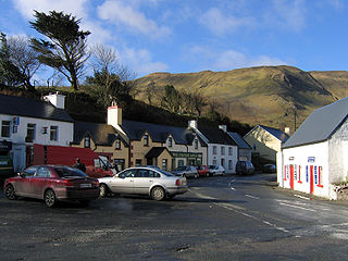
Keel is a village on Achill Island in County Mayo, Ireland.

The N59 road is a national secondary road in Ireland. It commences in County Sligo, south of Sligo Town at the Belladrehid interchange with the N4 north of Ballysadare. The route circles around the west of Ireland, passing west from Sligo into County Mayo and through Ballina. The N59 continues around Mayo, proceeding indirectly to Westport. Continuing south through Mayo into County Galway, the road passes through the village of Leenaun. The 182-year-old bridge in the centre of the village, carrying the road across the River Lahill, collapsed in floods on 18 July 2007. Due to the local terrain and road network, the diversionary route for getting from the south of the village to Westport was 110 km long. A temporary bridge was opened eight days after the floods, on 27 July. It has since been replaced by a new bridge.

The N26 road is a national primary road in northeast County Mayo in Ireland connecting the N5 road at Swinford with the N58 at Foxford and then on to the N59 road at Ballina. The road also meets six regional roads along its route, and it is 29.79 kilometres (18.51 mi) long.

The Midland Great Western Railway (MGWR) was the third largest Irish gauge railway company in Ireland. It was incorporated in 1845 and absorbed into the Great Southern Railways in 1924. At its peak the MGWR had a network of 538 miles (866 km), making it Ireland's third largest network after the Great Southern and Western Railway (GS&WR) and the Great Northern Railway of Ireland.

Mulranny —sometimes spelled as 'Mallaranny', 'Mulrany', 'Malaranny', 'Mullaranny', 'Mullranny' or 'Mulranny'—is a seaside village on the isthmus between Clew Bay and Blacksod Bay in County Mayo, Ireland. Mulranny, located at the foot of the Nephin Mountain Range, has a number of blue flag beaches and a coastal lagoon. The Corraun Peninsula, which contains three mountain peaks, is situated across Clew Bay.
Dooagh is a village located on Achill Island in County Mayo, Ireland. It is best known for the nearby Keem Bay, a Blue Flag beach.
The Corraun Peninsula, also spelt Currane, is a peninsula in County Mayo, on the west coast of Ireland. It extends out from the mainland towards Achill Island.

Tonragee or Tonregee is a village on the Currane peninsula in County Mayo, Ireland. The townlands of Tonregee East and Tonregee West are in the civil parish of Achill in the historical barony of Burrishoole. As of the 2011 census, these townlands had a population of 102 and 54 people respectively.

The Great Western Greenway is a greenway rail trail in County Mayo, Ireland. It is 42 kilometres long and begins in Westport and ends in Achill, passing through the towns of Newport and Mulranny as it runs along the coast of Clew Bay. It is an off-road trail intended for use by cyclists and walkers. It follows the route of the former Achill extension of the Westport railway line, which was constructed in the 1890s and closed in 1937. An estimated 300 people cycle and walk the trail each day, which was constructed at a cost of €5.7 million. The first section, from Newport to Mulranny, was opened in April 2010. It was named as the 2011 Irish winner of the European Destinations of Excellence award. The full route was opened by Taoiseach Enda Kenny, T. D. and Minister of State for Tourism and Sport, Michael Ring, T. D., on 29 July 2011.

The Wild Atlantic Way is a tourism trail on the west coast, and on parts of the north and south coasts, of Ireland. The 2,500 km driving route passes through nine counties and three provinces, stretching from County Donegal's Inishowen Peninsula in Ulster to Kinsale, County Cork, in Munster, on the Celtic Sea coast.

The Dublin–Galway Greenway is a partially completed 'coast-to-coast' greenway and partial rail trail, in Ireland, funded by the Department of Transport, which is due to become the western section of EuroVelo EV2, a cycle route from Galway, Ireland, crossing Europe and ending in Moscow, Russia. The 276 kilometres (171 mi) route was planned to be completed by 2020. It is due to be the fourth greenway in Ireland, after the Great Southern Trail, the Great Western Greenway and the Waterford Greenway.

