R112 road (Ireland)

Last updated

IRL R112.svg
R112 road
Bóthar R112
R112 road (Templeville Road).jpg
R112 road with cycle lanes (red)
Route information
Length15.2 km [1]  (9.4 mi)
Location
Country Ireland
Primary
destinations
Highway system

The R112 road is a regional road in south Dublin, Ireland. [2] It begins at the junction with the R148 road at Chapelizod and arcs southeastwards, then eastwards across the middle of south Dublin, ending at the Mount Merrion junction of the R138. The road is a single carriageway, with cycle lanes on some stretches. Improvements to the road have been made over the last 10 years, the most significant being at Dundrum Cross where the road was widened to make room for the new Luas bridge and Dundrum bypass (R117 road).

Contents

The official description of the R112 from the Roads Act 1993 (Classification of Regional Roads) Order 2012 [2] reads:

R112: Chapelizod - Churchtown - Mount Merrion, County Dublin
Between its junction with R148 at Chapelizod Bypass in the city of Dublin and its junction with R138 at Stillorgan Road in the county of Dun Laoghaire — Rathdown via Kylemore Road and Walkinstown Avenue in the city of Dublin: Saint Peters Road, Greentrees Road, Templeville Road and Springfield Avenue, Dodder View Road and Dodder Park Road in the county of South Dublin: Dodder Park Road, Braemor Road, Churchtown Road Upper, Taney Road, Mount Anville Road and Fosters Avenue in the county of Dun Laoghaire — Rathdown.

The R112 is 15.2 kilometres (9.4 mi) long (map of the road).

R112 looking west to crossroads at Dundrum and the Luas Dargan Bridge. R112-Dundrum.jpg
R112 looking west to crossroads at Dundrum and the Luas Dargan Bridge.
Mount Anville Road section of R112 due south between Mount Merrion and Goatstown. Deer Park entrance at left. R112-DeerPark Dublin.JPG
Mount Anville Road section of R112 due south between Mount Merrion and Goatstown. Deer Park entrance at left.

Route

Transport

54A bus stop on the R112 54A bus stop in Dublin.jpg
54A bus stop on the R112

The following bus routes use the R112:

An on-street bike lane starts at the Walkinstown roundabout and continues to Templeoge, at the junction of the R137. There, it changes to an off-street bike lane until the junction with the R114 road, where it switches back to an on-street lane. Following the junction at Ely Arch, there is an off-street bike lane until the crossroads at Dundrum. After this, only short stretches of the route have on-street bike lanes, though there are plans to add to this route in the proposed Goatstown development plan. [3]

Points of interest

Upgrades

Future plans

A feasibility study has explored the idea of running the proposed Luas Line E along the Upper Churchtown Road from the existing Luas Green Line at Dundrum, before turning off to the R821 road, towards Nutgrove. However, this project is unlikely to proceed soon due to scarce revenue and doubts about the sustainability of the line. Currently, there are plans to upgrade the junction with the R821. [4] The proposed Goatstown development plan is likely to make small changes to the road layout at that section of the route. In 2021, an orbital bus route was proposed along the R112 from Walkinstown to Blackrock. [5] [6]

See also

Related Research Articles

<span class="mw-page-title-main">Southside, Dublin</span> Informal region in Dublin, Ireland

The Southside is the part of Dublin city that lies south of the River Liffey. It is an informal but commonly used term. In comparison to the city's Northside, it has historically been regarded as wealthier and more privileged, with several notable exceptions.

<span class="mw-page-title-main">Churchtown, Dublin</span> Affluent suburb of Dublin, Ireland

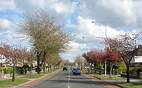
Churchtown is a largely residential affluent suburb on the southside of Dublin, between Rathfarnham and Dundrum.

<span class="mw-page-title-main">Clonskeagh</span> Suburb of Dublin, Ireland

Clonskeagh or Clonskea, is a small southern suburb of Dublin, Ireland. The district straddles the River Dodder.

<span class="mw-page-title-main">Goatstown</span> Suburb of Dublin, Ireland

Goatstown is a small Southside suburb of Dublin, Ireland. To the west is Dundrum, to the east is Blackrock, to the south is Kilmacud, and to the north is Clonskeagh. The area is bordered by Mount Merrion to which it shares many local amenities. Entrances to University College Dublin can be found on Roebuck Road, and due to the areas proximity to the campus, the suburb is highly attractive to university students. It is mainly a residential area, with a primary school called Our Lady's Grove, and two all-girls secondary schools, Mount Anville Secondary School and Our Lady's Grove Secondary School. There are amenities such as restaurants, a pub, a post office and various shops. With the recent implementation of the frequent S6 bus route to Blackrock via UCD Belfield recently, the area now benefits from connection to the DART line, as well as being served by the 11 Dublin Bus route through the centre of the village.

Mount Merrion is a suburb of Dublin, Ireland. It is roughly 7 kilometres (5 mi) south of Dublin city centre and is situated on and around the hill of the same name.

<span class="mw-page-title-main">Nutgrove</span>

Nutgrove is an area in Churchtown, County Dublin.

<span class="mw-page-title-main">Kilmacud</span> Suburb of Dublin, Ireland

Kilmacud is a suburban area of Dublin in Dún Laoghaire–Rathdown, Ireland, at least partly contiguous with Stillorgan.

<span class="mw-page-title-main">Taney Parish</span>

The Parish of Taney is a populous parish in the Church of Ireland, located in the Dundrum area of Dublin.

<span class="mw-page-title-main">R825 road (Ireland)</span> Regional road in south Dublin, Ireland

The R825 road is a regional road in south Dublin, Republic of Ireland. The road starts in Clonskeagh at the junction with the R117 and passes through Goatstown, Kilmacud and Stillorgan before ending at a junction with the N31 in Blackrock, County Dublin. The route is 7.6 km (4.7 mi) in length and is single carriageway apart from a small 2 lane section beside the N11.

<span class="mw-page-title-main">R133 road (Ireland)</span> Regional road in south Dublin, Ireland

The R133 road is a regional road in south Dublin, Ireland. The road starts at Goatstown and runs in a southerly direction towards Sandyford before acting as a link road for the M50.

<span class="mw-page-title-main">R826 road (Ireland)</span> Regional road in south Dublin, Ireland

The R826 road is a regional road in south Dublin, Ireland. The road runs from the Dundrum junction of the M50 as passes through or near Ballinteer, Dundrum and Balally before terminating at the junction with the R112 close to Goatstown. The route runs on mostly new road, built to facilitate the M50 and Dundrum Town Center and is 2.5 km long.

<span class="mw-page-title-main">R821 road (Ireland)</span> Road in Ireland

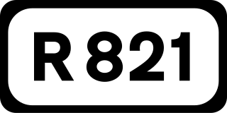
The R821 road is a regional road in south Dublin, Ireland. The road starts at the junction with the R115 in Rathfarnham and passes through Nutgrove before terminating at Churchtown.

<span class="mw-page-title-main">R109 road (Ireland)</span> Regional road in Ireland

The R109 road is a regional road in west Dublin, Ireland. It runs from Kylemore Road via Chapelizod, the Phoenix Park and the western edge of the city centre.

<span class="mw-page-title-main">R118 road (Ireland)</span> Regional road in Ireland

The R118 road is a regional road in south Dublin and Dún Laoghaire–Rathdown, Ireland. It links Kildare Street to Cherrywood.

Dublin Rathdown is a parliamentary constituency represented in Dáil Éireann, the lower house of the Irish parliament or Oireachtas, since the 2016 general election. The constituency elects three deputies on the system of proportional representation by means of the single transferable vote (PR-STV).

<span class="mw-page-title-main">R138 road (Ireland)</span> Road in Ireland

The R138 road is a regional road in Ireland. It commences at the south end of O'Connell Bridge in Dublin city centre. It proceeds along D'Olier Street, College Street.

<span class="mw-page-title-main">Dundrum Luas stop</span> Tram/light rail stop in Dublin, Ireland

Dundrum is a stop on the Luas light rail tram system in Dublin, Ireland which serves the suburb of Dundrum. It opened in 2004 as a stop on the Green Line, which re-uses the alignment of the Harcourt Street railway line which closed in 1958. Dundrum Luas stop is built on the same site as a former heavy rail station of the same name.

References

  1. Map of the route of R112, Google Maps. Retrieved: 2010-08-06.
  2. 1 2 Statutory Instrument 54 of 2012 — Roads Act 1993 (Classification of Regional Roads) Order 2012, Irish Statute Book (irishstatutebook.ie). Retrieved 2017-02-02.
  3. Goatstown Local Area Plan Drawing. Dún Laoghaire-Rathdown County Council, DLRCoCo.ie. Retrieved: 2010-08-07.
  4. Upper Churchtown Road / Nutgrove Avenue Quality Bus Corridor. Dún Laoghaire-Rathdown County Council, DLRCoCo.ie. Retrieved: 2010-08-07.
  5. "The overlooked orbital from BusConnects – future of dublin". 26 March 2023. Retrieved 4 July 2024.
  6. Garvey, Colm (19 July 2021). "South Dublin County Council Development Plan 2022-2028 Submissions" . Retrieved 4 July 2024.{{cite web}}: CS1 maint: url-status (link)

External sources