N51 road (Ireland)

Last updated

IRL N51.svg
N51 road
Bóthar N51
IMG N51road2888.jpg
N51 leaving Athboy
Route information
Length52.994 km (32.929 mi)
Location
Country Ireland
Primary
destinations
(bypassed routes in italics)
Highway system

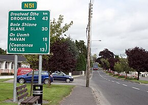
The N51 road is a national secondary road in Ireland. West to east, it starts in Delvin, County Westmeath at a junction with the N52. It passes through Athboy, a junction with M3 motorway, Navan and Slane, where it crosses the N2 road, all in County Meath, before crossing the M1 motorway and terminating near Drogheda in County Louth at a roundabout on the R132.

Contents

It is an unusual arrangement for a national secondary road to terminate at a regional road. However the R132 is the former N1 route (now by-passed by the M1 motorway) and is of a higher standard than most regional roads.

Upgrade

On 15 May 2009 Phase 2B of the N51 Navan Inner Relief Road was opened to traffic. This route provides a direct link between the N3/M3 Kells Road and the N51 Athboy Road. On the same day a further 3.9 kilometres of the realigned N51 which has been constructed as part of the M3 motorway scheme was opened to traffic, 2.5 kilometres of which is Type 1 dual carriageway.

See also

Related Research Articles

<span class="mw-page-title-main">M50 motorway (Ireland)</span> Orbital motorway around Dublin

The M50 motorway is a C-shaped orbital motorway in Dublin and the busiest motorway in Ireland. The current route was built in various sections over the course of 27 years, from 1983 to 2010. It begins at Dublin Port, running northward through the Dublin Port Tunnel and along a portion of the Airport Motorway. It then turns west at its junction with the M1, circling the northern, western and southern suburbs of Dublin, before merging with the M11 at Shankill in South East Dublin. The road forms part of European route E01.

<span class="mw-page-title-main">M1 motorway (Republic of Ireland)</span> Motorway connecting Dublin and the Northern Ireland border

The M1 motorway is a motorway in Ireland. It forms the large majority of the N1 national primary road connecting Dublin towards Belfast along the east of the island of Ireland. The route heads north via Swords, Drogheda and Dundalk to the Northern Irish border just south of Newry in County Armagh, where it joins the A1 road and further on, the M1 motorway in Northern Ireland. It also forms a significant part of the road connection between Dublin and the Northern Irish cities of Newry, and Lisburn. The route is part of European route E01.

<span class="mw-page-title-main">Roads in Ireland</span> Overview of roads in Ireland

The island of Ireland, comprising Northern Ireland and the Republic of Ireland, has an extensive network of tens of thousands of kilometres of public roads, usually surfaced. These roads have been developed and modernised over centuries, from trackways suitable only for walkers and horses, to surfaced roads including modern motorways. Driving is on the left-hand side of the road. The major routes were established before Irish independence and consequently take little cognisance of the border other than a change of identification number and street furniture. Northern Ireland has had motorways since 1962, and has a well-developed network of primary, secondary and local routes. The Republic started work on its motorway network in the early 1980s; and historically, the road network there was once somewhat less well developed. However, the Celtic Tiger economic boom and an influx of European Union structural funding, saw national roads and regional roads in the Republic come up to international standard quite quickly. In the mid-1990s, for example, the Republic went from having only a few short sections of motorway to a network of motorways, dual carriageways and other improvements on most major routes as part of a National Development Plan. Road construction in Northern Ireland now tends to proceed at a slower pace than in the Republic, although a number of important bypasses and upgrades to dual carriageway have recently been completed or are about to begin.

<span class="mw-page-title-main">N11 road (Ireland)</span> National primary road in Ireland

The N11 road is a national primary road in Ireland, running for 129 km (80 mi) along the east side of Ireland from Dublin to Wexford. It passes close to Bray, Greystones, Wicklow, Arklow, Gorey, and Enniscorthy. Beyond Wexford, the route continues to Rosslare as the N25. The road forms part of European route E01. As of July 2019 the N11/M11 is of dual carriageway or motorway standard from Dublin as far as Oilgate in County Wexford.

<span class="mw-page-title-main">National Development Plan</span> Large infrastructure developments in Ireland

National Development Plan is the title given by the Irish Government to a scheme of organised large-scale expenditure on (mainly) national infrastructure. The first five-year plan ran from 1988 to 1993, the second was a six-year plan from 1994 to 1999 and the third ran as a seven-year plan from 2000 to 2006. A fourth National Development Plan ran from 2007 to 2011. The main elements of the third plan were the development of a national motorway network between the major cities in Ireland. The upgrading of the rail network was a secondary scheme.

The N3 road is a national primary road in the Republic of Ireland, running between Dublin, Cavan and the border with County Fermanagh. The A509 and A46 roads in Northern Ireland form part of an overall route connecting to Enniskillen, and northwest to the border again where the N3 reappears to serve Ballyshannon in County Donegal.

<span class="mw-page-title-main">M1 motorway (Northern Ireland)</span> Motorway in Northern Ireland connecting Belfast and Dungannon

The M1 is a motorway in Northern Ireland. It is the longest motorway in Northern Ireland and runs for 38 miles (61 km) from Belfast to Dungannon through County Antrim, County Down, County Armagh and County Tyrone. It forms part of the route via the A1 in Northern Ireland between Belfast and Dublin as well as being a part of the unsigned European E01 and E18 routes.

<span class="mw-page-title-main">N52 road (Ireland)</span> Road in Ireland

The N52 road is a national secondary road in Ireland. It links the M7 motorway from just south of Nenagh, County Tipperary to the M1 motorway north of Dundalk in County Louth. The route forms a connection between the north east of Ireland and the mid west traversing the midlands. It interchanges with the M6 at Kilbeggan and at Tyrrellspass, the N4 at Mullingar, the N3 at Kells, and the N2 at Ardee before continuing towards Dundalk.

<span class="mw-page-title-main">N32 road (Ireland)</span> Former national road in Dublin, Ireland

The N32 road was a short national primary road in Ireland running from Junction 3 on the M50, to the Malahide road at Clare Hall. It is effectively a non-motorway section of the M50 Dublin C-Ring, but is only built to primary road status. A short part of the route had motorway restrictions on it as lead to the M1 / M50 interchange, as only motorway traffic can access both routes. In 2013, the road was renumbered as R139.

<span class="mw-page-title-main">R154 road (Ireland)</span> Road in Ireland

The R154 road is a regional road in Ireland, linking the R147 near Clonee, County Meath to Crossdoney in County Cavan. The road is single carriageway throughout. Many parts of the route have dangerous bends.

<span class="mw-page-title-main">Boyerstown</span>

Boyerstown is a townland in County Meath, Ireland. It is located off the N51 national secondary road 5 kilometres (3 mi) southwest of Navan. The M3 motorway runs through the townland.

<span class="mw-page-title-main">R132 road (Ireland)</span> Road in Ireland

The R132 road is one of Ireland's newest regional roads, having been classified following the opening M1 motorway which by-passes most of the old N1 route. The R132 is 98.9 kilometres (61.5 mi) long.

<span class="mw-page-title-main">R164 road (Ireland)</span> Regional road in Ireland

The R164 road is a regional road in Ireland, linking Kingscourt in County Cavan to the N51 near Athboy, County Meath.

<span class="mw-page-title-main">R162 road (Ireland)</span> Road in Ireland

The R162 road is a regional road in Ireland, linking Monaghan Town to Navan, County Meath. The route is 80 km (50 mi) long.

<span class="mw-page-title-main">Motorways in the Republic of Ireland</span>

In Ireland, the highest category of road is a motorway, indicated by the prefix M followed by a one- or two-digit number. The motorway network consists entirely of motorway-grade dual carriageways and is largely focused upon Dublin. There are also several three-lane motorways, while Ireland's busiest road, the M50, incorporates four-lane, five-lane, and six-lane stretches.

The Outer Orbital Route is a proposed motorway around the city of Dublin, Ireland; the route has also been known as the Leinster Outer Orbital Route and the Dublin Outer Orbital Route (DOOR). In 2008, the Government reaffirmed its support for the route, with construction to happen between 2011 and 2019. In 2015, work on the route has been deferred to 'after 2035'.

<span class="mw-page-title-main">R168 road (Ireland)</span> Road in Ireland

The R168 road is a regional road in Ireland, linking Drogheda to the N2 at Collon, County Louth.

<span class="mw-page-title-main">R147 road (Ireland)</span> Road in Ireland

The R147 is a regional road in Ireland. Its first section runs from St Peters Church in Phibsborough, Dublin to its junction with the M50. It then follows the route of a former section of the N3 between Clonee and Kells. It serves as an alternative route for non-motorway traffic and traffic wishing to avoid tolls on the M3.

<span class="mw-page-title-main">R102 road (Ireland)</span> Road in Ireland

The R102 road is a regional road in Dublin, Ireland, which describes a broad arc across the north of the city, connecting the N3 — at its M50 motorway intersection — to the R107 on the other side of the city.

<span class="mw-page-title-main">Delvin (barony)</span> Barony in Leinster, Ireland

Delvin is a barony in north-east County Westmeath, in Ireland. It was formed by 1672. It is bordered by County Meath to the east and three other baronies: Fore, Moyashel and Magheradernon and Farbill. The largest centre of population is Delvin.

References