 | |
|---|---|
| Bóthar R558 | |
 Oyster Tavern, Spa, on the R558 | |
| Location | |
| Country | Ireland |
| Highway system | |
The R558 road is a regional road in Ireland, linking Tralee and Fenit in County Kerry.
| | |
|---|---|
| Bóthar R558 | |
| Oyster Tavern, Spa, on the R558 | |
| Location | |
| Country | Ireland |
| Highway system | |
The R558 road is a regional road in Ireland, linking Tralee and Fenit in County Kerry.
It starts in Tralee at its junction with the R551 at Mounthawk Cross at the boundary between County Kerry and Tralee town and continues via Clogherbrien, Spa, Kilfernora and Fenit to Fenit Pier.
County Kerry is a county in Ireland. It is located in the South-West Region and forms part of the province of Munster. It is named after the Ciarraige who lived in part of the present county. The population of the county was 155,258 at the 2022 census,

Tralee is the county town of County Kerry in the south-west of Ireland. The town is on the northern side of the neck of the Dingle Peninsula, and is the largest town in County Kerry. The town's population was 23,691 as of the 2016 census, thus making it the eighth largest town, and 14th largest urban settlement, in Ireland. Tralee is well known for the Rose of Tralee International Festival, which has been held annually in August since 1959.
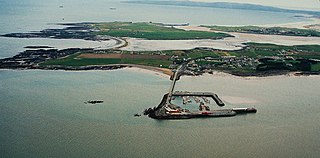
Fenit is a small village in County Kerry, Ireland, located on north side of Tralee Bay about 10 km (6 mi) west of Tralee town, just south of the Shannon Estuary. The bay is enclosed from the Atlantic by the Maharee spit which extends northwards from the Dingle peninsula. Fenit harbour is a mixed function sea port, where fishing, freight import and export, and a 136 berth marina are the main forms of business. As of the 2016 CSO census of Ireland, Fenit had a population of 538 people.

A regional road in the Republic of Ireland is a class of road not forming a major route, but nevertheless forming a link in the national route network. There are over 11,600 kilometres of regional roads. Regional roads are numbered with three-digit route numbers, prefixed by "R". The equivalent road category in Northern Ireland are B roads.

A national secondary road is a category of road in Ireland. These roads form an important part of the national route network but are secondary to the main arterial routes which are classified as national primary roads. National secondary roads are designated with route numbers higher than those used for primary roads, but with the same "N" prefix. Routes N51 and higher are all national secondary roads.
The N23 road is a national primary road in Ireland, and is located entirely in County Kerry. The route is one of the shorter national primary routes, merely forming a link road between the N21 Limerick – Tralee route at Castleisland to the N22 Tralee – Killarney – Cork route at Farranfore. This facilitates traffic passing in the Limerick – Killarney direction or vice versa, allowing it to avoid detouring into Tralee.

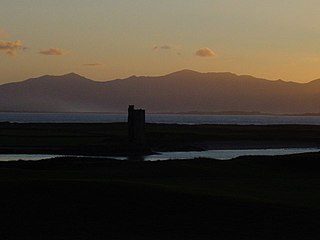
Tralee Bay is located in on the west coast of County Kerry, Ireland. It is situated between Kerry Head on the north side and the Maharees on the west and extends eastwards as far as the bridge at Blennerville. Several small rivers feed into the bay through the town of Tralee. Villages around the bay include; Ballyheigue, Fenit, Kilfinora, Spa, Blennerville, Camp and Castlegregory.
Fenit Island is a populated island, on the coast of County Kerry, connected to the mainland by a sandbar. Located in Tralee Bay, the island encloses Barrow Harbour. Historically, the area was called 'Fenit Within'. It is adjacent to the areas of 'Tawlacht' and 'Fenit Without' on the mainland. The terms within/without refer to the walled protection that surrounded parts of the island from attackers from the landward side.

Tralee Casement station is the terminus station on the Mallow–Tralee line and serves the town of Tralee in County Kerry. It is the most westerly railway station in Europe.
Barrow Harbour is a tidal inlet off Tralee Bay, County Kerry, Ireland. Once this was the major port for the region, servicing the monastic settlement of Ardfert and the general area of Tralee.

The R556 road is a regional road in Ireland, linking Tralee and Abbeydorney before joining up with the R551 at Glanerdalliv Bridge in County Kerry.
The R551 road is a regional road in Ireland, linking Tarbert and Tralee in County Kerry.

Blennerville is a small village and now a suburb of Tralee, County Kerry, Ireland. It is approximately 1 mile (1.6 km) west of the town centre on the N86 road to Dingle, where the River Lee enters Tralee Bay. The village was formerly Tralee's port, and is connected to the town centre by the Tralee Ship Canal. Part of Blennerville electoral division falls within the area of Tralee Town Council, and at the 2011 census had a population of 141. The remaining portion, outside the urban boundaries, had a 2011 population of 556.

The Great Southern Trail, comprising the Limerick Greenway and North Kerry Greenway, is a greenway rail trail under development in County Limerick and County Kerry in Ireland. As of October 2022, 40 kilometres of the Limerick Greenway and 10.5 kilometres of the North Kerry Greenway were completed. When fully completed, the route is intended to be 85 kilometres long and run from Limerick to Tralee. It is an off-road trail intended for use by cyclists and walkers along the route of the Limerick-Tralee line, formerly operated by the Great Southern and Western Railway, which opened between 1867 and 1880 and was closed in 1977.

The Tralee Ship Canal is a canal built for freight and passenger transportation from Tralee Bay to the town of Tralee in County Kerry, Ireland. The canal fell into disuse in the mid-20th century but has since been restored.

The Limerick–Tralee line, also known as the North Kerry line, is a former railway line from Limerick railway station to Tralee railway station in Ireland. It also has branch lines to Foynes and Fenit. Much of the line today has now been converted into a greenway, the Great Southern Trail.
Ireland's greenways are off-road routes for walkers, cyclists and other non-motorised transport in Ireland, which are often created as rail trails on abandoned sections of the Irish rail network. In the Republic of Ireland, several greenway initiatives have been centrally funded by the Irish government. In Northern Ireland, greenways are typically part of the collective British National Cycle Network (NCN).
Niall Charles Harrington, born in Dublin, was an Irish soldier, officer, military intelligence director, writer and broadcaster, campaigner for the memory of Charles Stuart Parnell and a union representative. His military career spanned the period from the War of Independence through to his retirement as a senior intelligence officer in 1959. During this time he wrote and narrated various historical features for different media. His Civil War memoirs were developed into a book, Kerry Landing, which was extended and published posthumously.

Spa is a village in County Kerry, Ireland. It is located on the R558 regional road between Tralee and Fenit, overlooking Tralee Bay. Spa lies in the historical barony of Trughanacmy.

The Tralee-Fenit Greenway is a greenway and rail trail in Ireland, which is due to form part of EuroVelo EV1 and the Great Southern Trail. The 14km route was planned to be completed by 2021, but delayed due to the COVID pandemic, with a rescheduled opening of summer 2022. The first phase of the greenway, comprising 6.5km of the route, was opened in June 2022, this was extended to 11.2km in October 2022.