 | |
|---|---|
| Bóthar N55 | |
 N55 at Tang, County Westmeath | |
| Route information | |
| Length | 78.815 km (48.973 mi) |
| Location | |
| Country | Ireland |
| Primary destinations |
|
| Highway system | |
The N55 road is a national secondary road in Ireland linking Athlone to Cavan town.
| | |
|---|---|
| Bóthar N55 | |
| N55 at Tang, County Westmeath | |
| Route information | |
| Length | 78.815 km (48.973 mi) |
| Location | |
| Country | Ireland |
| Primary destinations |
|
| Highway system | |
The N55 road is a national secondary road in Ireland linking Athlone to Cavan town.
In October 2017, a public consultation began into the re-routing of the Athlone to Ballymahon section of the road. [1] The route affects areas such as Annaghgortagh, and Kilkenny West [1] Plans were still in development in summer 2018. [2]
(Southwest to Northeast)
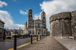
Athlone is a town on the border of County Roscommon and County Westmeath, Ireland. It is located on the River Shannon near the southern shore of Lough Ree. It is the second most populous town in the Midlands Region with a population of 21,349 in the 2016 census.
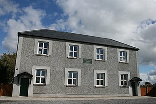
Tang is a village and a half-parish in County Westmeath, on the N55 national secondary road between Athlone and Ballymahon, County Longford. Tang is in the parish of Drumraney. It is in County Westmeath but on the border with County Longford from which it is separated by the 'Dungorman River which flows into Lough Ree 3 km downstream via the River Inny.

County Longford is a county in Ireland. It is in the province of Leinster. It is named after the town of Longford. Longford County Council is the local authority for the county. The population of the county was 46,634 at the 2022 census. The county is based on the historic Gaelic territory of Annaly (Anghaile), formerly known as Teffia (Teathbha).
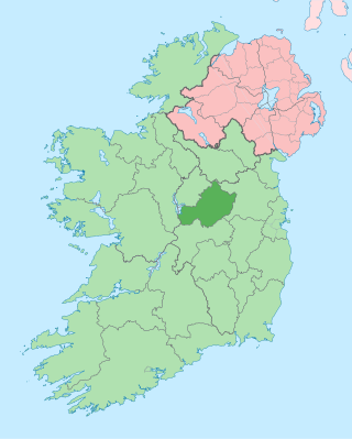
County Westmeath is a county in Ireland. It is in the province of Leinster and is part of the Eastern and Midland Region. It formed part of the historic Kingdom of Meath, which was named Mide because the kingdom was located in the geographical centre of Ireland. Westmeath County Council is the administrative body for the county, and the county town is Mullingar. At the 2022 census, the population of the county was 95,840.

County Cavan is a county in Ireland. It is in the province of Ulster and is part of the Border Region. It is named after the town of Cavan and is based on the historic Gaelic territory of East Breffny (Bréifne). Cavan County Council is the local authority for the county, which had a population of 76,176 at the 2016 census.

Ballymahon on the River Inny is a town in the southern part of County Longford, Ireland. It is located at the junction of the N55 National secondary road and the R392 regional road.

Cavan is the county town of County Cavan in Ireland. The town lies in Ulster, near the border with County Fermanagh in Northern Ireland. The town is bypassed by the main N3 road that links Dublin with Enniskillen, Ballyshannon and Donegal Town.

Edgeworthstown or Mostrim is a small town in County Longford, Ireland. The town is in the east of the county, near the border with County Westmeath. Nearby towns are Longford 12 km to the west, Mullingar 26 km to the east, Athlone 40 km to the south and Cavan 42 km to the north.

The N6 road is a national primary road in Ireland from junction 11 on the M4 motorway at Kinnegad to Galway city. The N6 and N4 form a continuous motorway or dual carriageway from Dublin city centre to Galway City passing in an east–west direction through the midlands of Ireland. Most of the road is motorway standard with the exception of the Athlone bypass and stretches of urban road in Galway City, which are the only sections of the road that remain designated as N6 dual carriageway. There is one toll on the road outside Galway city. Major upgrades to the road were completed in December 2009 completing the first intercity motorway/dual carriageway in Ireland and the New Junctions of M6 are built and will be 164 km.
The N3 road is a national primary road in the Republic of Ireland, running between Dublin, Cavan and the border with County Fermanagh. The A509 and A46 roads in Northern Ireland form part of an overall route connecting to Enniskillen, and northwest to the border again where the N3 reappears to serve Ballyshannon in County Donegal.

A regional road in the Republic of Ireland is a class of road not forming a major route, but nevertheless forming a link in the national route network. There are over 11,600 kilometres of regional roads. Regional roads are numbered with three-digit route numbers, prefixed by "R". The equivalent road category in Northern Ireland are B roads.

The Diocese of Ardagh and Clonmacnoise is a Roman Catholic diocese in Ireland.

Lanesborough–Ballyleague, more commonly known simply as Lanesborough, is a town in the midlands of Ireland. Lanesborough is on the County Longford (east) side and Ballyleague on the County Roscommon (west) side of the River Shannon. They are located at the northern tip of Lough Ree on the N63 national secondary road at its junction with the R371 and R392. The town of Longford is 16 km north-east on the N63, the town of Roscommon is 15 km south-west on the N63, the town of Ballymahon is 20 km south-east on the R392 and the town of Strokestown is 15 km north-west on the R371.

The R446 road is a regional road in Ireland. The road connects Kinnegad in County Westmeath to Galway City. Prior to the construction of the M6 motorway the R446 formed the main N6 road connecting Dublin and Galway. Following the opening of the M6; the old N6 road was downgraded to regional road status and was designated as the R446. The road is an alternative route between Galway and Dublin and runs in parallel to the M6.

The R392 road is a regional road in Ireland linking Lanesborough, County Longford on the N63 to Mullingar, County Westmeath.

The River Inny is a river within the Shannon River Basin in Ireland. It is 88.5 kilometres (55.0 mi) in length, and has a number of lakes along its course.

Crossdoney is a village and townland in County Cavan, Ireland. The village is on the R154 regional road where it terminates at a junction with the R198. Peculiarly, all buildings in the village sit on one side of the road, and this gives rise to the widely used local expression: "All to one side like Crossdoney".

The Dublin-Galway Greenway is a partially completed 'coast-to-coast' greenway and partial rail trail, in Ireland, funded by the Department of Transport, which is due to become the western section of EuroVelo EV2, a cycle route from Galway, Ireland, crossing Europe and ending in Moscow, Russia. The 276 km route was planned to be completed by 2020. It due to be the fourth greenway in Ireland, after the Great Southern Trail, the Great Western Greenway and the Waterford Greenway.

Kilkenny West, previously Maherquirke or Dillons country, is a barony in west County Westmeath, Ireland. It was formed by 1542. It is bordered by County Longford to the west; it is also bordered by three other Westmeath baronies: Rathconrath, Brawny and Clonlonan. The largest centre of population in the barony is the village of Glassan.
The Athlone to Mullingar Cycleway is a long-distance cycling and walking trail in County Westmeath, which forms a section of the Dublin-Galway Greenway. It is a 42 kilometres long rail-trail over the disused Athlone-Mullingar rail line beginning in Athlone and ending in Mullingar.