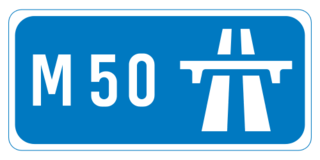
The M50 motorway is a C-shaped orbital motorway in Dublin and the busiest motorway in Ireland. The current route was built in various sections over the course of 27 years, from 1983 to 2010. It begins at Dublin Port, running northward through the Dublin Port Tunnel and along a portion of the Airport Motorway. It then turns west at its junction with the M1, circling the northern, western and southern suburbs of Dublin, before merging with the M11 at Shankill in South East Dublin. The road forms part of European route E01.

The island of Ireland, comprising Northern Ireland and the Republic of Ireland, has an extensive network of tens of thousands of kilometres of public roads, usually surfaced. These roads have been developed and modernised over centuries, from trackways suitable only for walkers and horses, to surfaced roads including modern motorways. Driving is on the left-hand side of the road. The major routes were established before Irish independence and consequently take little cognisance of the border other than a change of identification number and street furniture. Northern Ireland has had motorways since 1962, and has a well-developed network of primary, secondary and local routes. The Republic started work on its motorway network in the early 1980s; and historically, the road network there was once somewhat less well developed. However, the Celtic Tiger economic boom and an influx of European Union structural funding, saw national roads and regional roads in the Republic come up to international standard quite quickly. In the mid-1990s, for example, the Republic went from having only a few short sections of motorway to a network of motorways, dual carriageways and other improvements on most major routes as part of a National Development Plan. Road construction in Northern Ireland now tends to proceed at a slower pace than in the Republic, although a number of important bypasses and upgrades to dual carriageway have recently been completed or are about to begin.
The N7 road is a national primary road in Ireland, connecting Limerick and Dublin. The majority of the route is motorway standard and is designated as the M7 motorway. At the Rosbrien interchange in Limerick the route continues as the N18 dual carriageway to Galway, Shannon and Ennis. The road passes through the midlands of Ireland, and acts as a trunk route out of Dublin for the N8 and N9 national primary routes to Cork and Waterford respectively. It forms part of European route E20.

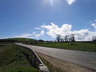
The N11 road is a national primary road in Ireland, running for 129 km (80 mi) along the east side of Ireland from Dublin to Wexford. It passes close to Bray, Greystones, Wicklow, Arklow, Gorey, and Enniscorthy. Beyond Wexford, the route continues to Rosslare as the N25. The road forms part of European route E01. As of July 2019 the N11/M11 is of dual carriageway or motorway standard from Dublin as far as Oilgate in County Wexford.

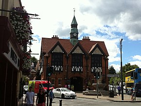
Greystones is a coastal town and seaside resort in County Wicklow, Ireland. It lies on Ireland's east coast, 3.5 km (2.2 mi) south of Bray and 24 km (15 mi) south of Dublin city centre and has a population of 22,009, according to the 2022 census. The town is bordered by the Irish Sea to the east, Bray Head to the north and the Wicklow Mountains to the west. It is the second largest town in County Wicklow.
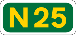
The N25 road is a national primary road in Ireland, forming the route from Cork to Rosslare Europort via Waterford City. The road is part of the E30 European route and a short section is also part of the E01 European route. It forms part of the proposed Atlantic Corridor route.
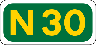
The N30 road is a national primary road in Ireland. It connects the N25 road and M11 motorway, providing a link running east-northeast through County Wexford, between New Ross and Enniscorthy. This provides for a more direct national route between the two towns, as the N25 and N11 both run to Wexford town, eastwards from New Ross and southwards from Enniscorthy respectively.

The N71 road is a national secondary road traversing counties Cork and Kerry in Ireland. Towns and villages along the route, westward from Cork city, include Innishannon, Bandon, Clonakilty, Skibbereen, Bantry and Glengarriff in County Cork. Continuing westwards from Glengarriff into County Kerry, the route passes Kenmare and terminates at Killarney.

Newtownmountkennedy is a small town in County Wicklow, Ireland. It developed within the historic townland of Ballygarny, although all that remains is a motte where a church, graveyard and a castle or tower house once stood just 0.85 km (0.53 mi) north of the town. It acquired its present name in the mid-seventeenth-century, when Sir Robert Kennedy, M.P. for Kildare, made it his principal residence. It is just off the N11 road to Wexford, just south of Kilpedder and south-west of Greystones. It is about 15 km (9.3 mi) north of Wicklow town, 15 km (9.3 mi) south of Bray and approximately 35 km (22 mi) from Dublin. This town has one of the longest place names in Ireland, so is sometimes abbreviated to NTMK.

Loughlinstown is a southern Dublin suburb, located in Dún Laoghaire–Rathdown, on the N11 national road.

The N80 road is a national secondary road in Ireland that runs southeastwards from its junction with the N52 and R443 in the town of Tullamore in County Offaly, to the N30 at Ballynahallin, just north of Enniscorthy in County Wexford, a distance of 114.683 km. Total length is 114.683 km (71.261 mi).
The R772 road is a regional road in Ireland which comprises disconnected sections of road which once formed part of the N11 but which have now been by-passed, joined by some new road sections and some former local roads.

The R117 road is a regional road in Ireland. The route (north-south) starts Harcourt Road at the end of the South Circular Road on the southside of Dublin city centre. It crosses the Grand Canal and goes through the suburbs of Ranelagh, Milltown, Windy Arbour, Dundrum, Sandyford, Stepaside and Kilternan before passing through the Scalp into County Wicklow.

The R741 road is a regional road in County Wexford, Ireland. From its junction with the R772 in Gorey it takes a southerly route to its junction with the R730 in the centre of Wexford Town, where it terminates.

European route E1 is a series of roads in Europe, part of the United Nations International E-road network, running from Larne, Northern Ireland to Seville, Spain. There is a sea crossing between Rosslare Harbour, in Ireland, and Ferrol, but no ferry service. The road also passes through Portugal – past the city of Porto, through the capital, Lisbon, and then south to the Algarve, passing Faro before reaching the Spanish border west of Huelva.

The R730 road is a regional road in County Wexford, Ireland. From its junction with the R702 in Kiltealy it takes a southeasterly route to its junction with the R741 in the centre of Wexford Town, continuing south to Blackhorse to its junction on a roundabout with the N25 Wexford bypass. En route it crosses the N30 national primary road. The road is 35 km (22 mi) long.

The N11 is a national route in South Africa which runs from the Botswana border at Groblersbrug, through Mokopane, Middelburg, Ermelo and Newcastle to end at the N3 just after Ladysmith.

The R762 road is a regional road in County Wicklow, Ireland, which connects the R761 at Greystones to the N11 national primary road.

The R768 road is a regional road in Ireland which connects J7 of the N11 to the junction of the R761 at Irishtown, Bray. The road is commonly known as the Southern Cross or the Southern Bypass, though it is officially known as the Southern Ring Road.

The R918 road is a regional road in Ireland which connects J6 of the N11 to the R761 at Little Bray. The majority of the known as the Dargle Road and the Upper Dargle Road.