
The island of Ireland, comprising Northern Ireland and the Republic of Ireland, has an extensive network of tens of thousands of kilometres of public roads, usually surfaced. These roads have been developed and modernised over centuries, from trackways suitable only for walkers and horses, to surfaced roads including modern motorways. Driving is on the left-hand side of the road. The major routes were established before Irish independence and consequently take little cognisance of the border other than a change of identification number and street furniture. Northern Ireland has had motorways since 1962, and has a well-developed network of primary, secondary and local routes. The Republic started work on its motorway network in the early 1980s; and historically, the road network there was once somewhat less well developed. However, the Celtic Tiger economic boom and an influx of European Union structural funding, saw national roads and regional roads in the Republic come up to international standard quite quickly. In the mid-1990s, for example, the Republic went from having only a few short sections of motorway to a network of motorways, dual carriageways and other improvements on most major routes as part of a National Development Plan. Road construction in Northern Ireland now tends to proceed at a slower pace than in the Republic, although a number of important bypasses and upgrades to dual carriageway have recently been completed or are about to begin.
The N7 road is a national primary road in Ireland, connecting Limerick and Dublin. The majority of the route is motorway standard and is designated as the M7 motorway. At the Rosbrien interchange in Limerick the route continues as the N18 dual carriageway to Shannon and Ennis. The road passes through the midlands of Ireland, and acts as a trunk route out of Dublin for the N8 and N9 national primary routes to Cork and Waterford respectively. It forms part of European route E20.

The N12 road is one of the shortest national primary roads in the Republic of Ireland, running 6.87 km (4.27 mi) from outside Monaghan to the border with County Armagh, Northern Ireland, at Ardgonnell Bridge outside Middletown. The N12 is part of an overall route running from Cavan Town to Belfast.

The R113 road is a regional road in Ireland. Located in Dublin, it forms a semi-orbital route around the south of the city. As of 2007, clockwise, it starts at the N31 at Temple Hill in Blackrock and ends at a junction with the N4 at Palmerstown.

The N16 road is a national primary road in Ireland. It begins in County Sligo in the northwest of Ireland, and ends at Blacklion, County Cavan, at the border with Northern Ireland, where it becomes the A4 road. At 47.49 kilometres (29.51 mi), The N16 is one of the shorter national primary routes, as it forms only part of a major route from Sligo to Enniskillen and onwards to Belfast.

The R148 road is one of Ireland's regional roads which was classified following the opening of a by-passed national primary road.

A national secondary road is a category of road in Ireland. These roads form an important part of the national route network but are secondary to the main arterial routes which are classified as national primary roads. National secondary roads are designated with route numbers higher than those used for primary roads, but with the same "N" prefix. Routes N51 and higher are all national secondary roads.
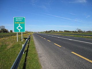
The N52 road is a national secondary road in Ireland. It links the M7 motorway from just south of Nenagh, County Tipperary to the M1 motorway north of Dundalk in County Louth. The route forms a connection between the north east of Ireland and the mid west traversing the midlands. It interchanges with the M6 at Kilbeggan and at Tyrrellspass, the N4 at Mullingar, the N3 at Kells, and the N2 at Ardee before continuing towards Dundalk.
The N59 road is a national secondary road in Ireland. It commences in County Sligo, south of Sligo Town at the Belladrehid interchange with the N4 north of Ballysadare. The route circles around the west of Ireland, passing west from Sligo into County Mayo and through Ballina. The N59 continues around Mayo, proceeding indirectly to Westport. Continuing south through Mayo into County Galway, the road passes through the village of Leenaun. The 182-year-old bridge in the centre of the village, carrying the road across the River Lahill, collapsed in floods on 18 July 2007. Due to the local terrain and road network, the diversionary route for getting from the south of the village to Westport was 110 km long. A temporary bridge was opened eight days after the floods, on 27 July. It has since been replaced by a new bridge.

The R446 road is a regional road in Ireland. The road connects Kinnegad in County Westmeath to Galway City. Prior to the construction of the M6 motorway the R446 formed the main N6 road connecting Dublin and Galway. Following the opening of the M6; the old N6 road was downgraded to regional road status and was designated as the R446. The road is an alternative route between Galway and Dublin and runs in parallel to the M6.

The R156 road is a regional road in Ireland, linking Dunboyne in County Meath to the N4 in County Westmeath. The road is single carriageway throughout. Many parts of the route have dangerous bends.

The N60 road is a national secondary road in Ireland, linking Roscommon town to Castlebar, County Mayo. The main towns along the route are Roscommon, Ballymoe, Castlerea, Ballyhaunis, Claremorris, Balla, and Castlebar.
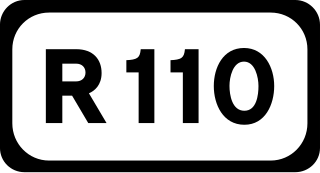
The R110 road is a regional road in Ireland which goes from St Stephen's Green to Red Cow, Dublin. Its route is completely within the Dublin urban area.

The N87 road is a national secondary road in the north of County Cavan, Ireland.

The R183 road is a regional road in the Republic of Ireland, linking Clones to Castleblayney in County Monaghan. The route is 36 km (22 mi) long.

Ireland has an extensive network of public roads which connect all parts of the country with each other. Roads in Ireland are currently classified as motorways, National Primary routes, National secondary routes, Regional roads and Local roads. The introduction of this classification system began in 1977.

The R329 road is a regional road in east central County Mayo in Ireland. It connects the N17 road at Shanvaghera – via Knock – to the N17 road at Ballyfarnagh, 6.6 kilometres (4.1 mi) away.

The R317 road is a regional road in County Mayo in Ireland. It connects the N59 at Newport to the R312 road at Boggy, 13.5 kilometres (8.4 mi) away.

The R318 road is a regional road in County Mayo in Ireland. It connects the N26 at Foxford to the R310 at Cuingbeg, 4.3 kilometres (2.7 mi) away.
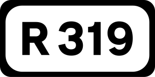
The R319 road is a regional road in County Mayo in Ireland. It connects the N59 at Mulranny to Keem Strand on Achill Island, 35.4 kilometres (22.0 mi) away.

