Strabane is a town in County Tyrone, Northern Ireland.

Lifford is the county town of County Donegal, Ireland, the administrative centre of the county and the seat of Donegal County Council, although the town of Letterkenny is often mistaken as holding this role.

Lough Foyle, sometimes Loch Foyle, is the estuary of the River Foyle, on the north coast of Ireland. It lies between County Londonderry in Northern Ireland and County Donegal in the Republic of Ireland. Sovereignty over the waters has been in dispute since the Partition of Ireland.
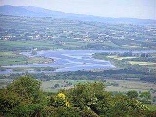
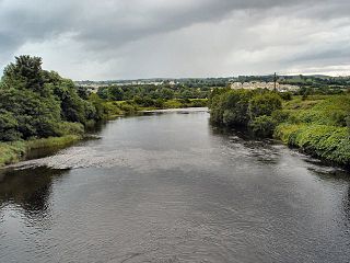
The River Foyle is a river in west Ulster in the northwest of the island of Ireland, which flows from the confluence of the rivers Finn and Mourne at the towns of Lifford in County Donegal, Republic of Ireland, and Strabane in County Tyrone, Northern Ireland. From here it flows to the city of Derry, where it discharges into Lough Foyle and, ultimately, the Atlantic Ocean. The total length of the River Foyle is 32 km (20 mi). The river separates part of County Donegal from parts of both County Londonderry and County Tyrone. The district of County Donegal that borders the western bank of the River Foyle is traditionally known as the Laggan. This district includes the villages of St Johnston and Carrigans, both of which are nestled on the banks of the River.

The N13 road is a national primary road in Ireland, running in County Donegal in Ulster from Stranorlar to just outside Derry. This road connects Letterkenny to Sligo, Derry and onwards to other destinations.

The N14 road is a national primary road in the Republic of Ireland. The entirety of the route is located in the northwest of Ireland, in County Donegal, connecting Manorcunningham to Lifford in the east. Here it connects to the N15 near the border with Northern Ireland and along the A38 to Strabane in County Tyrone.

The R236 road runs in County Donegal in Ulster, and links Stranorlar, via Convoy and Raphoe, to St Johnston and Carrigans, becoming the A40 into Derry in Northern Ireland.
The N15 road is a national primary road in the north-west of Ireland. It runs from Sligo to Lifford, County Donegal. It forms part of the proposed Atlantic Corridor route. It also goes to the border with Northern Ireland.

The Republic of Ireland–United Kingdom border, sometimes referred to as the Irish border or British–Irish border, runs for 499 km (310 mi) from Lough Foyle in the north-west of Ireland to Carlingford Lough in the north-east, separating the Republic of Ireland from Northern Ireland.
The River Finn is a river in the Republic of Ireland that passes through County Donegal and County Tyrone in Northern Ireland. From Lough Finn, the river goes to Ballybofey and Stranorlar before joining the River Mourne.

The Foyle Bridge is a bridge in Derry, Northern Ireland. The central cantilever span of the bridge is the second longest on the island of Ireland, at 234 metres (767 ft), and the whole suspended bridge structure including the approach spans is 866 metres long (2839 ft).

Lifford Bridge is a cross-border bridge spanning the River Foyle in Ireland. It connects Strabane in County Tyrone, Northern Ireland, and Lifford in County Donegal in the Republic of Ireland, joining the A38 road to the N15. It remains a vital part of the trans-border route from the North, West and East of County Donegal, to Dublin via County Tyrone.

The A5 is a major primary route in Northern Ireland. It links the city of Derry in County Londonderry with Aughnacloy, County Tyrone via the towns of Strabane and Omagh. Just south of Aughnacloy is the border with the Republic of Ireland, where the A5 meets the N2 to Dublin. Between them the A5 and N2 are the main road link between County Donegal in the Republic and Dublin.

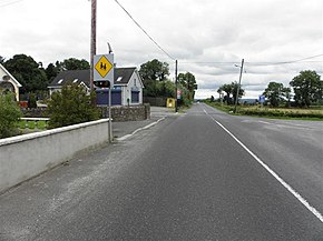
St Johnston, officially Saint Johnstown, is a village, townland, and an electoral division in County Donegal, Ireland. It is in the Laggan district of East Donegal on the left bank of the River Foyle. It is in the civil parish of Taughboyne and barony of Raphoe North, on the R236 (Lifford–Newtowncunningham) road where it overlaps the R265 (Carrigans–Raphoe) road. The village is about 12 kilometres (7.5 mi) south of Derry.

Porthall is a village and townland in County Donegal, Ireland. The village is located on the west bank of the River Foyle, in The Laggan district of East Donegal, on the R265 road. The nearest town is Lifford, the county town.

Mongavlin Castle also known as Mongevlin Castle is a ruined castle on the west bank of the River Foyle, approx 3 km south of St Johnston, County Donegal, Ireland. It was once a stronghold of the O'Donnell's, Lords of Tyrconnell.

The A38 links Strabane, County Tyrone and the A5 through the meadows of the river Foyle and over Lifford Bridge to Lifford, the County Town of County Donegal, where it links into the N14 and the N15. The N15, which continues into County Donegal to Stranorlar, Donegal Town, Ballyshannon, Bundoran and then leaving County Donegal, before heading to Sligo. The N14, which continues through Rossgeir, Drumbeg to Letterkenny.

The A40 links Derry in the North West of Northern Ireland to Raphoe in County Donegal.

Raphoe North, or North Raphoe, is a barony in County Donegal, Ireland. Baronies were mainly cadastral rather than administrative units. They acquired modest local taxation and spending functions in the 19th century before being superseded by the Local Government (Ireland) Act 1898.
The Burn Dale is a burn or small river in the east of County Donegal in Ulster, the northern province in Ireland. The burn is also known in English as the Dale Burn, the Burn Deele, the Burndale River, the Deele River or the River Deele. In the Ulster Scots dialect, a 'burn' is a stream or small river.