County Sligo is a county in Ireland. It is located in the Border Region and is part of the province of Connacht. Sligo is the administrative capital and largest town in the county. Sligo County Council is the local authority for the county. The population of the county was 65,535 at the 2016 census. It is noted for Benbulben Mountain, one of Ireland's most distinctive natural landmarks.

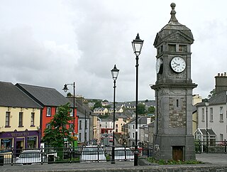
Ballymote is a market town in southern County Sligo, approx. 24 km south east of Sligo town in the province of Connacht, which is located in the north-west of Ireland. Ballymote lies in the barony of Corran. A commuter town with a strong history of independent enterprises along with firm local health, school, and transport services. It is located on the main Dublin to Sligo Train Line, and situated 10 minutes from the N4 / N17 Roadways. Ballymote serves a large hinterland area in south east County Sligo.
Boyle is a town in County Roscommon, Ireland. It is located at the foot of the Curlew Mountains near Lough Key in the north of the county. Carrowkeel Megalithic Cemetery, the Drumanone Dolmen and the lakes of Lough Arrow and Lough Gara are also close by. As of 2016, the population of the town was 2,568.

Eamon Scanlon is a former Irish Fianna Fáil politician who served as a Teachta Dála (TD) from 2007 to 2011 and 2016 to 2020. He was a Senator for the Agricultural Panel from 2002 to 2007.

Collooney or Coloony is a town in County Sligo, Ireland.
Gurteen or Gorteen is a village in County Sligo, Ireland. It is in the civil parish of Kilfree in the baronry of Coolavin.

A regional road in the Republic of Ireland is a class of road not forming a major route, but nevertheless forming a link in the national route network. There are over 11,600 kilometres of regional roads. Regional roads are numbered with three-digit route numbers, prefixed by "R". The equivalent road category in Northern Ireland are B roads.

The R293 road is a regional road in Ireland linking the N17, via a junction in the townland of Ballinabole near Collooney in County Sligo, to the outskirts of Ballyhaunis in County Mayo. En route it passes through three towns, Ballymote and Gorteen in County Sligo and Ballaghaderreen in County Roscommon. The road is 55 km (34 mi) long.

The R296 road is a regional road in County Sligo, Ireland that runs from Ballymote to Quarryfield where it merges into R294 road from Gorteen to Tobercurry.

The Book of Ballymote, was written in 1390 or 1391 in or near the town of Ballymote, now in County Sligo, but then in the tuath of Corann.

Ballymote railway station serves the town of Ballymote in County Sligo, Ireland.

Ballymote Castle is a large rectangular keepless castle, built around 1300. It is located in the townland of Carrownanty on the outskirts of Ballymote in southern County Sligo, Ireland. This area was known historically as Átha Cliath an Chorainn, which roughly translates as The Ford of the Hurdles of Corann. It is the last of the Norman castles in Connacht. It was probably built in order to protect the newly won possessions of Richard Óg de Burgh, 2nd Earl of Ulster, in County Sligo, some distance from an earlier motte.

The N61 road is a national secondary road in County Roscommon in Ireland, linking Athlone, Roscommon, Tulsk, and Boyle. It also connects the N6, N63, N60, N5, and N4 national primary and national secondary roads, as well as seven regional roads. The road is 74.193 kilometres (46.101 mi) long.

The R285 road is a regional road in Ireland linking the N4 at a point east of Boyle, County Roscommon to the R280 at Mountallen. The road lies entirely within County Roscommon.

The R361 road is a regional road mainly in County Roscommon, Ireland. South to north the route connects Williamstown to Boyle.

Bunnanadden, Bunnanaddan or Bunninadden is a small village in south County Sligo, Ireland. It is on the R296 road, 9 km from Tubbercurry and 8 km from Ballymote.
The R294 road is a regional road in counties Roscommon, Mayo, and Sligo in Ireland. It connects the N4 road near Boyle to the N26 and N59 roads in Ballina, 66 kilometres (41 mi) away.
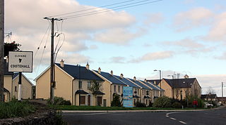
Cootehall is a village in County Roscommon, Ireland. It is located on the River Boyle, between Boyle and Carrick-on-Shannon near Lough Key Forest Park in the north of the county.
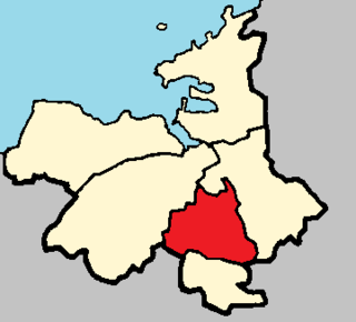
Corran is a historic barony in south County Sligo in Ireland. It corresponds to the ancient túath of Corann.
Kilfree Junction is a former station in County Sligo and was located on the Sligo line in the townland of Cloontycarn between Boyle and Ballymote about 1 mile (1.6 km) from the track summit though the Curlew Mountains. It enabled connections on the branch line to Ballaghaderreen in County Roscommon. The junction faced Ballymote and Sligo station and was a trailing junction in the Boyle and Dublin Connolly direction requiring a reversal. The station was not located near any significant settlement, the nearest, Gorteen in County Sligo being over 6 km away.