
County Cavan is a county in Ireland. It is in the province of Ulster and is part of the Northern and Western Region. It is named after the town of Cavan and is based on the historic Gaelic territory of East Breffny (Bréifne). Cavan County Council is the local authority for the county, which had a population of 81,704 at the 2022 census.

The N12 road is one of the shortest national primary roads in the Republic of Ireland, running 6.87 km (4.27 mi) from outside Monaghan to the border with County Armagh, Northern Ireland, at Ardgonnell Bridge outside Middletown. The N12 is part of an overall route running from Cavan Town to Belfast.

A regional road in the Republic of Ireland is a class of road not forming a major route, but nevertheless forming a link in the national route network. There are over 11,600 kilometres of regional roads. Regional roads are numbered with three-digit route numbers, prefixed by "R". The equivalent road category in Northern Ireland are B roads.

The R201 road is a regional road in Ireland linking Drumsna in County Leitrim to Belturbet in County Cavan.

The N16 road is a national primary road in Ireland. It begins in County Sligo in the northwest of Ireland, and ends at Blacklion, County Cavan, at the border with Northern Ireland, where it becomes the A4 road. At 47.49 kilometres (29.51 mi), The N16 is one of the shorter national primary routes, as it forms only part of a major route from Sligo to Enniskillen and onwards to Belfast.

A national secondary road is a category of road in Ireland. These roads form an important part of the national route network but are secondary to the main arterial routes which are classified as national primary roads. National secondary roads are designated with route numbers higher than those used for primary roads, but with the same "N" prefix. Routes N51 and higher are all national secondary roads.

Dowra is a village and townland in northwest County Cavan, Ireland. Located in a valley on Lough Allen, it is the first village on, and marks the most uppermost navigable point of, the River Shannon. On one side of its bridge is County Cavan; on the other is County Leitrim. The nucleus of the village is situated on the Cavan side. It is located on the junction of the R200 and R207 regional roads.
The R154 road is a regional road in Ireland, linking the R147 near Clonee, County Meath to Crossdoney in County Cavan. The road is single carriageway throughout. Many parts of the route have dangerous bends.

The N83 road is a national secondary road in Ireland that runs from its junction with the N17 just south of Ireland West Airport Knock in County Mayo to a point just north of Tuam, County Galway where it rejoins the N17. On 27 September 2017, the old N17 from the Kilmore Roundabout in Tuam to the junction with the N6 in Galway city was redesignated as the N83.

The R323 road is a regional road in County Mayo, Ireland. Going from west to east, the route connects the towns of Kiltimagh, Knock, and Ballyhaunis. En route it crosses over the N17 national primary road at a grade separated junction in the village of Knock.

The R202 road is a regional road in Ireland linking Dromod in County Leitrim to Swanlinbar in County Cavan. En route it passes through Mohill and Ballinamore.
The R162 road is a regional road in Ireland, linking Monaghan Town to Navan, County Meath. The route is 80 km (50 mi) long.

The R702 road is a regional road in Ireland which runs west-east from the R712 at Coolgrange in County Kilkenny through Gowran before crossing into County Carlow at Goresbridge. It continues to Borris, passes through the Blackstairs Mountains via the Scullogue Gap into County Wexford and continues east until it terminates at a junction with the R890 in Enniscorthy.

The R284 road is a regional road in Ireland linking Sligo to Leitrim village in County Leitrim. En route it passes through Ballygawley, Ballyfarnan, Geevagh and Keadue. The road is 46 km (29 mi) long.

The R280 road is a regional road in Ireland linking Bundoran in County Donegal in the north to Carrick-on-Shannon in County Leitrim. En route it passes through Kinlough, Manorhamilton, Drumkeeran and Leitrim village. The road is 74 km (46 mi) long.
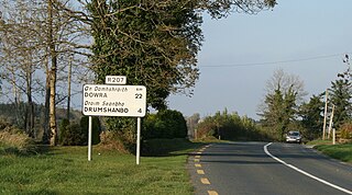
The R207 road is a regional road in Ireland linking the N16 national primary road near the Northern Ireland border to the R280 10 km north of Carrick-on-Shannon in County Leitrim.

The R147 is a regional road in Ireland. Its first section runs from St Peters Church in Phibsborough, Dublin to its junction with the M50. It then follows the route of a former section of the N3 between Clonee and Kells. It serves as an alternative route for non-motorway traffic and traffic wishing to avoid tolls on the M3.

Derrynacreeve is a townland in the civil parish of Templeport, County Cavan, Ireland. It lies in the Roman Catholic parish of Corlough and barony of Tullyhaw.

Bellavally Lower, is a townland in the civil parish of Templeport, County Cavan, Ireland. The local pronunciation is Bealbally. It lies in the Roman Catholic parish of Glangevlin and barony of Tullyhaw.

Bellavally Upper, in Gaelic= 'Béal an Bhealaigh Uachtarach', meaning The Upper Entrance to the Pass or Gap, is a townland in the civil parish of Templeport, County Cavan, Ireland. The local pronunciation is Bealbally. It lies in the Roman Catholic parish of Glangevlin and barony of Tullyhaw.

