
The island of Ireland, comprising Northern Ireland and the Republic of Ireland, has an extensive network of tens of thousands of kilometres of public roads, usually surfaced. These roads have been developed and modernised over centuries, from trackways suitable only for walkers and horses, to surfaced roads including modern motorways. The major routes were established before Irish independence and consequently take little cognisance of the border other than a change of identification number and street furniture. Northern Ireland has had motorways since 1962, and has a well-developed network of primary, secondary and local routes. The Republic started work on its motorway network in the early 1980s; and historically, the road network there was once somewhat less well developed. However, the Celtic Tiger economic boom and an influx of European Union structural funding, saw national roads and regional roads in the Republic come up to international standard quite quickly. In the mid-1990s, for example, the Republic went from having only a few short sections of motorway to a network of motorways, dual carriageways and other improvements on most major routes as part of a National Development Plan. Road construction in Northern Ireland now tends to proceed at a slower pace than in the Republic, although a number of important bypasses and upgrades to dual carriageway have recently been completed or are about to begin.
The N8 road is a national primary road in Ireland, connecting Cork with Dublin via the M7. The N8 is further classified by the United Nations as the entirety of the European route E 201, part of the trans-Europe International E-road network. The road is motorway standard from junction 19 on the M7 to the Dunkettle interchange in Cork City and is designated as the M8 motorway. From here the route continues into City city centre and terminates at the N22 road at St. Patrick's Street. The M8 motorway was completed in May 2010, replacing the single carriageway sections of the old N8 and bypassing towns on the main Cork to Dublin road. It is now possible to travel from Cork to Dublin on the M/N8 in about 2 hours 30 minutes. The route commences just south of Portlaoise, and reaches Cork via the midlands and the Golden Vale of Ireland, through Counties Laois, Kilkenny, Tipperary, Limerick and Cork.

The N16 road is a national primary road in Ireland. It begins in County Sligo in the northwest of Ireland, and ends at Blacklion, County Cavan, at the border with Northern Ireland, where it becomes the A4 road. At 47.49 kilometres (29.51 mi), The N16 is one of the shorter national primary routes, as it forms only part of a major route from Sligo to Enniskillen and onwards to Belfast.

A national secondary road is a category of road in Ireland. These roads form an important part of the national route network but are secondary to the main arterial routes which are classified as national primary roads. National secondary roads are designated with route numbers higher than those used for primary roads, but with the same "N" prefix. Routes N51 and higher are all national secondary roads.

The N76 road is a national secondary road in Ireland. It links the N10 national primary on the ring road south of Kilkenny, County Kilkenny to the N24 national primary route east of Clonmel in County Tipperary.

A national primary road is a road classification in Ireland. National primary roads form the major routes between the major urban centres. There are 2649 km of national primary roads. This category of road has the prefix "N" followed by one or two digits. Motorways are prefixed "M" followed by one or two digits.

The N77 road is a national secondary road in Ireland. It links the N10 national primary on the ring road south of Kilkenny, County Kilkenny to the M7 motorway at Portlaoise in County Laois.

The N83 road is a national secondary road in Ireland that runs from its junction with the N17 just south of Ireland West Airport Knock in County Mayo to a point just north of Tuam, County Galway where it rejoins the N17. On 27 September 2017, the old N17 from the Kilmore Roundabout in Tuam to the junction with the N6 in Galway city was redesignated as the N83.
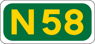
The N58 road is a national secondary road in Ireland. It links the N26 national primary road at Foxford in Co Mayo to the N5 national primary road at Bellavary, 11km to the south. As such it forms part of the main route linking the three largest towns in Co Mayo - Castlebar and Westport on the N5 and Ballina on the N26.
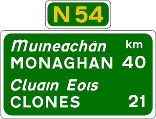
The N54 is a national secondary road in the Republic of Ireland connecting the towns of Monaghan and Cavan. It is in three sections, separated by two sections in Northern Ireland classified as parts of the A3.

The R730 road is a regional road in County Wexford, Ireland. From its junction with the R702 in Kiltealy it takes a southeasterly route to its junction with the R741 in the centre of Wexford Town, continuing south to Blackhorse to its junction on a roundabout with the N25 Wexford bypass.

The R666 road is a regional road in Ireland which runs west-east from the R639 in Fermoy town centre to the bridge over the River Blackwater on the outskirts of Lismore. The road passes through Ballyduff, and beneath the River Blackwater viaduct which carries the M8 motorway. The R666 begins in Fermoy as the Rathhealy Road. From here to its merger with the R667 road 3km south of Kilworth, the R666 was once part of the historic road linking Dublin and Cork. It was mapped as such by Herman Moll in his 1714 New Map of Ireland.

Ireland has an extensive network of public roads which connect all parts of the country with each other. Roads in Ireland are currently classified as motorways, National Primary routes, National secondary routes, Regional roads and Local roads. The introduction of this classification system began in 1977.
A local road in the Republic of Ireland is a public road not classified as a national primary road, national secondary road, or regional road but nevertheless forming a link in the national network of roads. Local roads are numbered with four- or five-digit route numbers, prefixed by "L".

The R665 road is a regional road in Ireland. The route runs from Mitchelstown to Clonmel via Ballyporeen, Clogheen and Ardfinnan, passing through parts of counties Cork and Tipperary. The R665 was once a key part of the historic route from Dublin to Cork and was mapped as such as late as 1778. A turnpike road, it was also a key part of the route linking Mallow with Dublin, via today's N73.
The R670 road is a regional road in Ireland. The route runs from its junction with the R639 and N24 at Cloughabreeda 2 km north of Cahir through Cahir town and onwards for a further 8 km to Ardfinnan, where it joins the R665 road. The R670 is located entirely in County Tipperary.

The R667 road is a regional road in Ireland. The route runs from its junction with the N8 1 km from Kilworth for approximately 5 km until it meets the R666 road northeast of Fermoy. The R667 was once part of the main road from Dublin to Cork, and was mapped as such by Herman Moll in his New Map of Ireland in 1714. The road is located entirely in County Cork.
The R613 road is a regional road in Ireland which runs west-east from the R589 in Halfway to the N28 in the centre of Ringaskiddy. The road forms a vital part of the road network south of Cork City.

The R729 road is a regional road in County Carlow and County Wexford in Ireland. It connects the R702 near Borris to the R714 near New Ross, 22.1 km (13.7 mi) to the south.

The R177 road is a regional road in Ireland linking Lisdoo and the Border with Northern Ireland in County Louth. The road continues as the A29 across the border in Northern Ireland.
