County Leitrim is a county in Ireland. It is in the province of Connacht and is part of the Northern and Western Region. It is named after the village of Leitrim. Leitrim County Council is the local authority for the county, which had a population of 35,087 according to the 2022 census.

Ballinamore is a small town in County Leitrim, Ireland.

Drumshanbo is a small town situated in the heart of County Leitrim, Ireland. Drumshanbo is surrounded by a scenic area of soft rolling hills, woodlands, lakes and the Sliabh an Iarainn and Arigna mountains. It is a well preserved town with traditional pubs, shops, and restaurants.

Lough Allen is a lake on the River Shannon in northeastern Connacht, Ireland. Most of the lake is in County Leitrim, with a smaller part in County Roscommon. The lake lies to the south of the River Shannon's source, near the Iron Mountains, and is the uppermost of the three main lakes on the river. The other two, Lough Ree and Lough Derg are much further to the south.
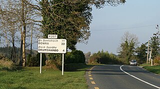
The R207 road is a regional road in Ireland linking the N16 national primary road near the Northern Ireland border to the R280 10 km north of Carrick-on-Shannon in County Leitrim.

The R282 road is a regional road in County Leitrim, Ireland connecting the N16 in Manorhamilton with Rossinver and across the border around Lough Melvin becoming the B53 to Garrison, County Fermanagh.

The R286 road is a regional road in Ireland. It is largely a loop road from the N16 linking Sligo and north County Leitrim.
The R278 road is a regional road in Ireland. It is a loop road from the R286 road in Counties Sligo and Leitrim.

The R288 road is a regional road in Ireland. It connects the R287 and R286 roads in County Leitrim.

The R287 road is a regional road in Ireland linking Sligo and the R280 in County Leitrim.

The R289 road is a regional road in Ireland linking the R287 and the R280 in County Leitrim. The road is 5.9 km (3.7 mi) long.

The R199 road is a regional road in Ireland linking the R198 and R202 roads in Counties Cavan and Leitrim. It is a key road for access to the Shannon–Erne Waterway.

The R210 road is a regional road in Ireland linking the R209 and R208 roads in south county Leitrim. Approximately 1.9 km (1.2 mi) in length, the R210 road runs along the south-east border of Carrickaport Lough and also runs along the north-west border of Lough Scur over Drumcong townland, the placename in Irish: Droim Conga translating to "Ridge of the narrow neck".

The R299 road is a regional road in Ireland linking the N4 and R280 roads in County Leitrim. The road is 7.8 kilometres (4.8 mi) long northbound, shorter southbound.

The R231 road is a regional road in Ireland. It is a loop road from the N15 road in County Donegal. Most of the road is part of the Wild Atlantic Way.

The R341 road is a regional road in Ireland. It is a loop road from the N59 road in County Galway. South of the R342, the road is part of the Wild Atlantic Way.
The R238 road is a regional road in Ireland. It is a ring road around the Inishowen Peninsula in County Donegal. The R238 is also part of the main road from Derry to Buncrana. Sections of the road form part of the Wild Atlantic Way. In July 2010, the road was the site of Ireland's worst road crash resulting in eight deaths.

The R241 road is a regional road in the north-west of Ireland. It is a coastal road on the eastern side of Inishowen, a peninsula in the north of County Donegal in Ulster. The road forms part of the Wild Atlantic Way. Part of the road is on the Inishowen Head Loop walking trail.

The R246 road is a regional road in Ireland. It is a road mostly on the Fanad peninsula in County Donegal. The northernmost section of the road at Portsalon forms part of the Wild Atlantic Way.

Allen Gaels Gaelic Athletic Association is a Gaelic football and ladies' Gaelic football club based in Drumshanbo, County Leitrim, Ireland.