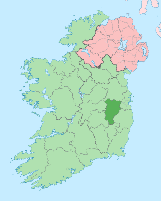
County Kildare is a county in Ireland. It is in the province of Leinster and is part of the Eastern and Midland Region. It is named after the town of Kildare. Kildare County Council is the local authority for the county, which has a population of 246,977.

The National University of Ireland, Maynooth, commonly known as Maynooth University (MU), is a constituent university of the National University of Ireland in Maynooth, County Kildare, Ireland. It was Ireland's youngest university until Technological University Dublin was established in 2019, as it was founded by the Universities Act, 1997 from the secular faculties of the now separate St Patrick's College, Maynooth, which was founded in 1795. Maynooth is also the only university town in Ireland, all other universities being based within cities.
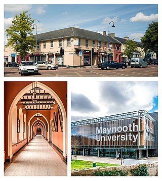
Maynooth is a university town in north County Kildare, Ireland. It is home to Maynooth University and St Patrick's College, a Pontifical University and Ireland's sole Roman Catholic seminary. Maynooth is also the seat of the Irish Catholic Bishops' Conference and holds the headquarters of Ireland's largest development charity, Trócaire. Maynooth is located 24 kilometres west of central Dublin.

The N4 road is a national primary road in Ireland, running from Dublin to the northwest of Ireland and Sligo town. The M6 to Galway diverges from this route after Kinnegad, while the N5 to Westport diverges at Longford town. Most sections of the N4 that are motorway-standard are designated the M4 motorway.
Celbridge is a town and townland on the River Liffey in County Kildare, Ireland. It is 23 km (14 mi) west of Dublin. Both a local centre and a commuter town within the Greater Dublin Area, it is located at the intersection of the R403 and R405 regional roads. As of the 2016 census, Celbridge was the third largest town in County Kildare by population, with over 20,000 residents.

Straffan is a village in County Kildare, Ireland, situated on the banks of the River Liffey, 25 km upstream of the Irish capital Dublin. As of the 2016 census, the village had a population of 853, a nearly two-fold increase since the 2006 census.

Kildare North is a parliamentary constituency represented in Dáil Éireann, the lower house of the Irish parliament or Oireachtas. The constituency elects 4 deputies on the system of proportional representation by means of the single transferable vote (PR-STV).

The R148 road is one of Ireland's regional roads which was classified following the opening of a by-passed national primary road.
County Kildare in the province of Leinster, Ireland, was first defined as a diocese in 1111, shired in 1297 and assumed its present borders in 1836. Its location in the Liffey basin on the main routes from Dublin to the south and west meant it was a valuable possession and important theatre of events throughout Irish history.
Maynooth GAA is a Gaelic Athletic Association (GAA) club in Maynooth, County Kildare, Ireland. It caters for the sporting and social needs of residential areas adjacent to its location for all ages through the promotion of Gaelic games — Gaelic football, hurling, camogie and handball.

Straffan Gaelic Football Club is a Gaelic football club in Straffan, County Kildare, Ireland.

The Kildare Hotel and Golf Club is a golf and leisure complex in the Republic of Ireland, located at Straffan, County Kildare. It is built on the original grounds of the Straffan estate, incorporating the 1830s Straffan House, and was owned by Michael Smurfit.

Leixlip Confey is a railway station in the north-eastern corner of County Kildare, Ireland. It is one of two stations that serve the civil parish of Leixlip, the other being Leixlip Louisa Bridge. Both stations lie on the Dublin to Maynooth commuter route.

The R135 road is one of Ireland's newest regional roads, being a reclassification of those sections of the former N2 which were bypassed when the N2(M2) Ashbourne By-Pass dual carriageway opened in 2006, and when the Carrickmacross, Castleblayney & Monaghan bypasses were completed.

The R417 road is a regional road in Ireland, which runs north-south from the R445 in Monasterevin, County Kildare to the R448 in Carlow, County Carlow.

The R114 road is a regional road in south Dublin, Ireland. The road runs from the city centre to Brittas in remote southwest County Dublin via Rathmines, Rathgar, Rathfarnham, Knocklyon, Firhouse and the mountainous area of Boharnabreena. The final stretch of the road runs just north of the border between County Dublin and County Wicklow, parallel to the Brittas River and a canal to the River Camac, which rises just to the north.

Taghadoe in County Kildare in Ireland is the site of an ancient monastic settlement and round tower. The site includes a graveyard and the ruins of a 19th-century church. It is situated 5 km from Maynooth, off the Straffan Road. The name is derived from Teach Tua or 'House of Tua' in Irish, Saint Tua the abbot of Clonmacnoise, was responsible for founding the monastic settlement here. The site dates back to the 6th century. The round tower was used for about 1000 years, but was left in ruins by the 17th century. Most of the burials in the graveyard were in the 17th and 18th century and it was used by Roman Catholics. A John Dillon of Carton had bequeathed £1,000 for the building of a church on the site; the Duke of Leinster was the executor of his will.
The R157 is a Regional road between Dunboyne and Maynooth in Ireland. It connects to the M3 motorway. This route runs in Counties Kildare and Meath.
The Lyreen River is a small river in County Kildare, Ireland, a tributary of the Rye River (Ryewater), and ultimately of the River Liffey.
Salt North is a barony in County Kildare, Ireland.

