The island of Ireland, comprising Northern Ireland and the Republic of Ireland, has an extensive network of tens of thousands of kilometres of public roads, usually surfaced. These roads have been developed and modernised over centuries, from trackways suitable only for walkers and horses, to surfaced roads including modern motorways. Driving is on the left-hand side of the road. The major routes were established before Irish independence and consequently take little cognisance of the border other than a change of identification number and street furniture. Northern Ireland has had motorways since 1962, and has a well-developed network of primary, secondary and local routes. The Republic started work on its motorway network in the early 1980s; and historically, the road network there was once somewhat less well developed. However, the Celtic Tiger economic boom and an influx of European Union structural funding, saw national roads and regional roads in the Republic come up to international standard quite quickly. In the mid-1990s, for example, the Republic went from having only a few short sections of motorway to a network of motorways, dual carriageways and other improvements on most major routes as part of a National Development Plan. Road construction in Northern Ireland now tends to proceed at a slower pace than in the Republic, although a number of important bypasses and upgrades to dual carriageway have recently been completed or are about to begin.
The N2 road is a national primary road in Ireland, running from Dublin to the border with Northern Ireland at Moy Bridge near Aughnacloy, County Tyrone to connect Dublin with Derry via the A5. A section of the route near Dublin forms the M2 motorway.

The N5 road is a national primary road in Ireland, connecting Longford town with Westport. It is the main access route from Dublin to most of County Mayo, including the county's largest towns, Castlebar, Ballina, and Westport.

The N14 road is a national primary road in the Republic of Ireland. The entirety of the route is located in the northwest of Ireland, in County Donegal, connecting Manorcunningham to Lifford in the east. Here it connects to the N15 near the border with Northern Ireland and along the A38 to Strabane in County Tyrone.

A national secondary road is a category of road in Ireland. These roads form an important part of the national route network but are secondary to the main arterial routes which are classified as national primary roads. National secondary roads are designated with route numbers higher than those used for primary roads, but with the same "N" prefix. Routes N51 and higher are all national secondary roads.

The N28 road is a national primary road in Ireland. It connects the port and village of Ringaskiddy to the N40 South Ring Road in Cork city.

A national primary road is a road classification in Ireland. National primary roads form the major routes between the major urban centres. There are 2649 km of national primary roads. This category of road has the prefix "N" followed by one or two digits. Motorways are prefixed "M" followed by one or two digits.

The N77 road is a national secondary road in Ireland. It links the N10 national primary on the ring road south of Kilkenny, County Kilkenny to the M7 motorway at Portlaoise in County Laois.

The N61 road is a national secondary road in County Roscommon in Ireland, linking Athlone, Roscommon, Tulsk, and Boyle. It also connects the N6, N63, N60, N5, and N4 national primary and national secondary roads, as well as seven regional roads. The road is 74.193 kilometres (46.101 mi) long.

The N83 road is a national secondary road in Ireland that runs from its junction with the N17 just south of Ireland West Airport Knock in County Mayo to a point just north of Tuam, County Galway where it rejoins the N17. On 27 September 2017, the old N17 from the Kilmore Roundabout in Tuam to the junction with the N6 in Galway city was redesignated as the N83.
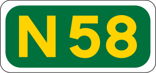
The N58 road is a national secondary road in Ireland. It links the N26 national primary road at Foxford in Co Mayo to the N5 national primary road at Bellavary, 11km to the south. As such it forms part of the main route linking the three largest towns in Co Mayo - Castlebar and Westport on the N5 and Ballina on the N26.

The R667 road is a regional road in Ireland. The route runs from its junction with the N8 1 km from Kilworth for approximately 5 km until it meets the R666 road northeast of Fermoy. The R667 was once part of the main road from Dublin to Cork, and was mapped as such by Herman Moll in his New Map of Ireland in 1714. The road is located entirely in County Cork.

The R324 road is a regional road in south central County Mayo in Ireland. It connects the N60 road near Balla to the R320 road near Kiltimagh. The road is 8.8 kilometres (5.5 mi) long.

The R321 road is a regional road in central County Mayo in Ireland. The road is discontinuous and it connects the N58 road at Ballylahan to the N5 road near Bohola, and after a 950m hiatus, it leaves the N5 at Toocananagh and joins the R320 in Kiltimagh. The road is 11.5 kilometres (7.1 mi) long.
The R330 road is a regional road in west central County Mayo in Ireland. It connects the N5 and N59 roads at Westport to the N84 road at the village of Partry, 21.9 kilometres (13.6 mi) away. It meets the R300 road between Cloonee and Partry.

The R177 road is a regional road in Ireland linking Lisdoo and the Border with Northern Ireland in County Louth. The road continues as the A29 across the border in Northern Ireland. The road is 5.5 km (3.4 mi) long.

The R185 road is a regional road in Ireland linking the N12 near Tyholland in County Monaghan and the border with Northern Ireland. The road passes through the village of Glaslough. Across the border, it continues as an unclassified route towards the villages of Tynan and Caledon.
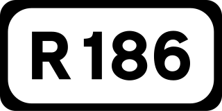
The R186 road is a regional road in Ireland linking Monaghan in County Monaghan and the Republic of Ireland–United Kingdom border. The road passes through the village of Tydavnet. The road is 18.5 km (11.5 mi) long.

The R213 road is a regional road in Ireland which links the N2 at Castleshane with the N12 near the border with Northern Ireland in County Monaghan. The road is 4.1 km (2.5 mi) long.

The R267 road is a regional road in County Donegal, Ireland. The road links Donegal Town with the N15, a road which runs around the eastern and south-eastern edge of Donegal Town. The N15 forms part of the main road between Derry and Sligo Town. The R267, parts of which are known as the Derry Road or the Ballybofey Road within Donegal Town, crosses the Drumenny Burn between The Northern Garage and the District Hospital, near where the burn enters the River Eske.T he road is 5.6 km (3.5 mi) long.