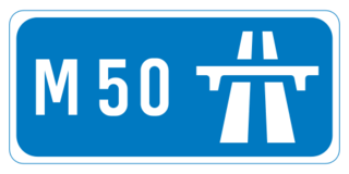
The M50 motorway is a C-shaped orbital motorway in Dublin and the busiest motorway in Ireland. The current route was built in various sections over the course of 27 years, from 1983 to 2010. It begins at Dublin Port, running northward through the Dublin Port Tunnel and along a portion of the Airport Motorway. It then turns west at its junction with the M1, circling the northern, western and southern suburbs of Dublin, before merging with the M11 at Shankill in South East Dublin. The road forms part of European route E01.

The A61 is a major trunk road in England connecting Derby and Thirsk in North Yorkshire by way of Alfreton, Clay Cross, Chesterfield, Sheffield, Barnsley, Wakefield, Leeds, Harrogate and Ripon. The road is closely paralleled by the M1 motorway between Derby and Leeds.
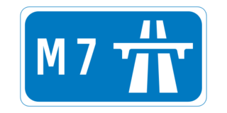
The M7 motorway is a motorway in Ireland. The motorway runs continuously from the outskirts of Naas in County Kildare to Rossbrien on the outskirts of Limerick City. The M7 forms part of the Dublin to Limerick N7 national primary road. The section of the motorway bypassing Naas, an 8 km stretch, was the first section of motorway to open in Ireland, in 1983. Following substantial works to extend the M7 to Limerick, by the end of 2010, the motorway replaced all of the old single-carriageway N7 route which is now designated as R445. At 166.5 km, the M7 is the longest motorway in Ireland.

The N11 road is a national primary road in Ireland, running for 129 km (80 mi) along the east side of Ireland from Dublin to Wexford. It passes close to Bray, Greystones, Wicklow, Arklow, Gorey, and Enniscorthy. Beyond Wexford, the route continues to Rosslare as the N25. The road forms part of European route E01. As of July 2019 the N11/M11 is of dual carriageway or motorway standard from Dublin as far as Oilgate in County Wexford.
South Dublin is a county in Ireland, within the province of Leinster and the Eastern and Midland Region. It is one of three successor counties to County Dublin, which was disestablished for administrative purposes in 1994. South Dublin County Council is the local authority for the county. The county contains both dense suburbs of Dublin and stretches of unpopulated mountain. In 2016 it had a population of 278,767, making it the third most populous county in the state.

The N4 road is a national primary road in Ireland, running from Dublin to the northwest of Ireland and Sligo town. The M6 to Galway diverges from this route after Kinnegad, while the N5 to Westport diverges at Longford town. Most sections of the N4 that are motorway-standard are designated the M4 motorway.

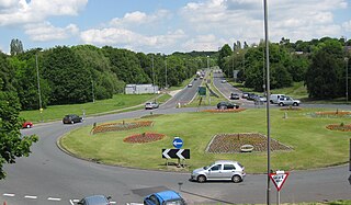
Lucan is a town in Ireland, located 12 km west of Dublin city centre on the River Liffey. It is near the Strawberry Beds and Lucan Weir, and at the confluence of the River Griffeen. It is mostly under the jurisdiction of South Dublin County Council with the exception of the North Lucan areas of Laraghcon, Coldblow and Saint Catherine's Park which are in the jurisdiction of Fingal County Council. Road access to Lucan is from the N4, and the M50 motorway at Junction 7.

The A426 road is a road in England which runs from the city of Leicester to the market town of Southam in Warwickshire via the towns of Lutterworth and Rugby.

The N6 road is a national primary road in Ireland from junction 11 on the M4 motorway at Kinnegad to Galway city. The N6 and N4 form a continuous motorway or dual carriageway from Dublin city centre to Galway City passing in an east–west direction through the midlands of Ireland. Most of the road is motorway standard with the exception of the Athlone bypass and stretches of urban road in Galway City, which are the only sections of the road that remain designated as N6 dual carriageway. There is one toll on the road outside Galway city. Major upgrades to the road were completed in December 2009 completing the first intercity motorway/dual carriageway in Ireland and the New Junctions of M6 are built and will be 164 km.
Adamstown is a planned suburban development, the first new town in Ireland since Shannon Town in the 1960s. Located circa 16 km from Dublin city centre, the development-in-progress is based on a 220 hectare Strategic Development Zone site south of the N4 road and Lucan, west of Liffey tributary the Griffeen River and north of the Grand Canal. No date has been set for the official granting of any specific long-term official status but development is underway since 2005 and as of 2015, perhaps 4,500 of a planned population of 25,000 were resident. The planned scale of development is 9,000 to 10,000 dwellings, with aligned supporting infrastructure including public transport links. Adamstown is in the jurisdiction of South Dublin County Council.

The N81 road is a national secondary road in Ireland, from the M50 motorway to Tullow, County Carlow, north to south. The N81 continues past Tullow for another 8 km to terminate at the village of Closh, County Carlow, where it intersects the N80. The N81 is 76.784 km (47.711 mi) long. The road is a dual carriageway between M50 motorway and west of Tallaght, known as the Tallaght Bypass or Blessington Road. It intersects with the M50 motorway at Junction 11. There are plans to extend the dual carriageway by 5 km (3.1 mi) to the urban boundary.

The R113 road is a regional road in Ireland. Located in Dublin, it forms a semi-orbital route around the south of the city. As of 2007, clockwise, it starts at the N31 at Temple Hill in Blackrock and ends at a junction with the N4 at Palmerstown.

The R445 road is a regional road in Ireland. The route is a non-motorway alternative route to the N7/M7 motorway between Naas and Limerick, and at 170 km it is one of the longest regional roads in Ireland. Indeed, much of the route comprises roads that were formerly part of the N7 between the cities, prior to motorway and other bypasses. Some of the R445 route also comprises local link roads to new N7/M7 route sections.
The A4174 is a major ring road in England which runs around the northern and eastern edge of Bristol, mainly in South Gloucestershire, and through the southern suburbs of the city. When it was first conceived it was planned to circle the whole of Bristol, and is commonly referred to as the "Avon Ring Road", or less accurately the "Bristol Ring Road", on road signs. The road does not circle the whole city, instead covering roughly half of the route. It is broken in part where it is concurrent with the A4.

The R710 road is a regional road in Ireland. Located in the south of Ireland at Waterford, it forms the Outer Ring Road around the south of the city. As of December 2006 it commences on the Old Kilmeaden Road at Knockhouse Lower, west of Waterford City and ends at a junction with the R683 on the Dunmore Road in the south-east of the city.

The A6 road in Northern Ireland runs for 71.4 miles (114.9 km) from Belfast to Derry, via County Antrim and County Londonderry. From Belfast to Randalstown the route has been superseded by a motorway. Mostly single carriageway, there are sections of dual carriageway in Antrim town centre and from Randalstown to Toome, including the Toome bypass. In urban and suburban districts of Belfast and Derry the route is single carriageway with 4 lanes. In rural parts, there are numerous climbing lanes along the route. The A6 is one of Northern Ireland's most important arterial routes, as the road runs between its two largest cities and urban areas. Between Randalstown and Derry the road forms part of European route E16. There is a new dual carriageway between Drumahoe and Dungiven, which will finish probably before 2023.

The A1237 road is a road that runs to the west and north of the city of York, England. It forms part of the York Outer Ring Road as either end of the route forms junctions with the A64 to the south-west and east of the city to act as a city distributor. Construction began in 1984 and consisted of three distinct building phases. The road took three years to complete and has been subject since to studies looking to improve traffic flow and reduce accidents. The National Speed Limit for an A Class Road applies.
The Leeds Outer Ring Road is a main road that runs around most of the perimeter of the city of Leeds, West Yorkshire, England. The ring road is approximately 25 miles (40 km) long and consists of single and dual carriageways. The road is not a loop and so is not a true ring road, although it is designated as such.
This article deals with transport in Waterford city in Ireland. The city is connected by road, rail, bus, air and sea. There are currently proposals for a bus rapid transit (BRT) system, consisting of bus trams, or streetcars, to be used in future.

A650 road is a main route through the West Yorkshire conurbation in England. The road goes from Keighley to Wakefield on a rough north west/south east axis for 25 miles (40 km). The route is mostly single carriageway with some dualled sections in the Aire Valley, Bradford and the approach to Wakefield from the M1.


