Ballymahon on the River Inny is a town in the southern part of County Longford, Ireland. It is located at the junction of the N55 National secondary road and the R392 regional road.

Mullingar is the county town of County Westmeath in Ireland. It is the third most populous town in the Midland Region, with a population of 20,928 in the 2016 census.

The Royal Canal is a canal originally built for freight and passenger transportation from Dublin to Longford in Ireland. It is one of two canals from Dublin to the River Shannon and was built in direct competition to the Grand Canal. The canal fell into disrepair in the late 20th century, but much of it has since been restored for navigation. The length of the canal to the River Shannon was reopened on 1 October 2010, but a final spur branch, to Longford Town, remains closed.

The N4 road is a national primary road in Ireland, running from Dublin to the northwest of Ireland and Sligo town. The M6 to Galway diverges from this route after Kinnegad, while the N5 to Westport diverges at Longford town. Most sections of the N4 that are motorway-standard are designated the M4 motorway.

Edgeworthstown or Mostrim is a small town in County Longford, Ireland. The town is in the east of the county, near the border with County Westmeath. Nearby towns are Longford 12 km to the west, Mullingar 26 km to the east, Athlone 40 km to the south and Cavan 42 km to the north.

A regional road in the Republic of Ireland is a class of road not forming a major route, but nevertheless forming a link in the national route network. There are over 11,600 kilometres of regional roads. Regional roads are numbered with three-digit route numbers, prefixed by "R". The equivalent road category in Northern Ireland are B roads.
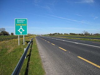
The N52 road is a national secondary road in Ireland. It links the M7 motorway from just south of Nenagh, County Tipperary to the M1 motorway north of Dundalk in County Louth. The route forms a connection between the north east of Ireland and the mid west traversing the midlands. It interchanges with the M6 at Kilbeggan and at Tyrrellspass, the N4 at Mullingar, the N3 at Kells, and the N2 at Ardee before continuing towards Dundalk.

Ardagh is a village in County Longford, Ireland. Ardagh is located towards the south of County Longford, 10 kilometres (6.2 mi) southwest of Longford town, located off the N4 road. Originally a site of pre-Christian worship, Ardagh became a site of Christian settlement with the arrival of Saint Patrick sometime between 434 and 435. The bulk of the village was laid-out in the mid-19th century.

The R156 road is a regional road in Ireland, linking Dunboyne in County Meath to the N4 in County Westmeath. The road is single carriageway throughout. Many parts of the route have dangerous bends.
The R390 road is a regional road in Ireland linking Athlone to Mullingar, all of it within County Westmeath. It passes through the town of Ballymore, and several hamlets, before terminating in Mullingar. The road is 43 km (27 mi) long.

The R400 road is a regional road in Ireland, linking Mullingar, County Westmeath to the R419 at Cushina, County Offaly.

The R394 road is a regional road in Ireland linking the N55 in County Cavan to Mullingar in County Westmeath. It passes through the town of Castlepollard and several villages and hamlets en route.

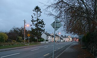
The R392 road is a regional road in Ireland linking Lanesborough, County Longford on the N63 to Mullingar, County Westmeath.
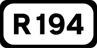
The R194 road is a regional road in Ireland linking Longford in County Longford to Virginia in County Cavan to Moynalty in County Meath. The road is 67 km (42 mi) long.

The R198 road is a regional road in Ireland, linking Longford in County Longford to Cavan town. The road is 56 km (35 mi) long.
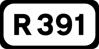
The R391 road is a regional road in Ireland linking Clara, County Offaly to Mullingar, County Westmeath. It passes through the villages of Horseleap and Dysart and several hamlets before terminating west of Mullingar.
The R397 road is a regional road in Ireland linking Longford Town to Ballymahon all in County Longford. It passes through the village of Keenagh en route. The road is 16 km (9.9 mi) long.

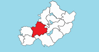
Moyashel and Magheradernon is a barony in the centre of County Westmeath, in the Republic of Ireland, formed by 1672. It is bordered by eight other baronies: Corkaree and Fore, Delvin and Farbill, Fartullagh and Moycashel and Rathconrath and Moygoish.
Rathconrath, previously the barony of Rathcomyrta, before that Daltons country, is a barony in the west of County Westmeath, in the Republic of Ireland. It was formed by 1542. It is bordered by County Longford to the north–west and five other Westmeath baronies: Moygoish to the north, Moyashel and Magheradernon to the east, Moycashel and Clonlonan to the south and Kilkenny West to the west. Note that the village of Rathconrath is not synonymous with the barony of the same name.

Farbill is a barony in east County Westmeath, in the Republic of Ireland. It was formed by 1672. It is bordered by County Meath to the south and east and three other baronies: Fartullagh, Moyashel and Magheradernon and Delvin. The largest centre of population in the barony is the town of Kinnegad.