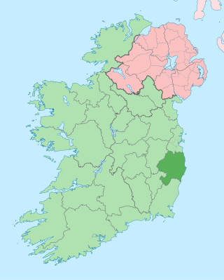
County Wicklow is a county in Ireland. The last of the traditional 32 counties, having been formed as late as 1606, it is part of the Eastern and Midland Region and the province of Leinster. It is bordered by the Irish Sea to the east and the counties of Wexford to the south, Carlow to the southwest, Kildare to the west, and South Dublin and Dún Laoghaire–Rathdown to the north.

Turlough Hill, also known as Tomaneena, is a 681-metre-high (2,234 ft) mountain in County Wicklow in Ireland and site of Ireland's only pumped-storage hydroelectricity plant. The power station is owned and operated by the ESB and can generate up to 292 megawatts (392,000 hp) of electricity at times of peak demand.

The Wicklow Mountains form the largest continuous upland area in Ireland. They occupy the whole centre of County Wicklow and stretch outside its borders into the counties of Dublin, Wexford and Carlow. Where the mountains extend into County Dublin, they are known locally as the Dublin Mountains. The highest peak is Lugnaquilla at 925 metres.

The N5 road is a national primary road in Ireland, connecting Longford town with Westport. It is the main access route from Dublin to most of County Mayo, including the county's largest towns, Castlebar, Ballina, and Westport.

The Wicklow Way is a 131-kilometre (81-mile) long-distance trail that crosses the Wicklow Mountains in Ireland. It runs from Marlay Park in the southern suburbs of Dublin through County Wicklow and ends in the village of Clonegal in County Carlow. It is designated as a National Waymarked Trail by the Irish Sports Council and is waymarked by posts with a yellow "walking man" symbol and a directional arrow. Typically completed in 5–7 days, it is one of the busiest of Ireland's National Waymarked Trails, with up to 24,000 people a year walking the most popular sections. The Way is also used regularly by a number of mountain running competitions.

A regional road in the Republic of Ireland is a class of road not forming a major route, but nevertheless forming a link in the national route network. There are over 11,600 kilometres of regional roads. Regional roads are numbered with three-digit route numbers, prefixed by "R". The equivalent road category in Northern Ireland are B roads.
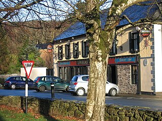
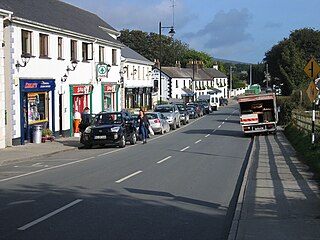
Laragh is a small village in County Wicklow, Ireland. It lies at the junction of three roads through the Wicklow Mountains and is primarily known for its proximity to the monastic settlement of Glendalough. Sally Gap and the Glenmacnass Waterfall are to the north, to the west is Glendalough and the Wicklow Gap, and to the south is the Glenmalure Valley.

Dunlavin is a village in County Wicklow, Ireland, situated about 50 kilometres (30 mi) south-west of Dublin. It is centred on the junction of the R412 and R756 regional roads. It was founded around the end of the 17th century and became a prominent town in the area for a time. The village is in a civil parish of the same name.

The R115 road is a regional road in counties Dublin and Wicklow in Ireland. It follows the Military Road for its entire length. The R115 is 40.5 km (25.2 mi) long; the full length of the Military Road is 57.9 km (36.0 mi).

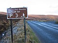
The R759 road is a regional road in Ireland running south-east to north-west through the Sally Gap in the Wicklow Mountains, from the R755 near Roundwood in East Wicklow to the N81 in West Wicklow. The other route through the Wicklow Mountains from east to west is the Wicklow Gap which is crossed by the R756.
The R755 road is a regional road in Ireland. It runs for its entire length in County Wicklow. From the village of Kilmacanogue on the N11 national primary road it goes north/south for 36 km (22 mi) to the town of Rathdrum.

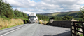
Wicklow Gap is one of the highest Irish mountain passes served by an asphalted road. It is located in County Wicklow, Ireland.

The R747 road is a regional road in Ireland running north-west/south-east from the M9 near Ballitore in County Kildare to Arklow in County Wicklow, a distance of 66 km (41 mi).
Tonelagee, is at 817 metres (2,680 ft), is the 25th–highest peak in Ireland on the Arderin scale, and the 33rd–highest peak on the Vandeleur-Lynam scale. Tonelagee is situated in the central sector of the Wicklow Mountains range, and sits on the main "central spine" of the range that runs from Kippure in the north, to Lugnaquillia in the south; and in particular, the continuous "central boggy ridge" that runs from the Sally Gap in the north, via Mullaghcleevaun, to Tonelagee. Tonelagee is the third highest peak in Wicklow after Lugnaquilla and Mullaghcleevaun.

Conavalla at 734 metres (2,408 ft), is the 69th–highest peak in Ireland on the Arderin scale, and the 85th–highest peak on the Vandeleur-Lynam scale. The summit of Conavalla sits just off the main "central spine" of the Wicklow Mountains, as it runs from Kippure in the north, to Lugnaquillia in the south. Conavalla's large massif to the north-east is described as a "wet and boggy barren plain" whose various shoulders dominate the head of the Glendalough valley, and the upper east-side of the Glenmalure valley.
The Shay Elliott Memorial race is a one-day road cycling race held in spring in Ireland. It is run in honour of Ireland's first professional cyclist, Seamus Shay Elliott and organised by Bray Wheelers. The race was previously known as the Route de Chill Mhantain, became the Shay Elliott Trophy in the late sixties, then the Shay Elliott Memorial after his death in 1971. The race is the most prestigious Irish one-day event after the national championships.

The R412 road is a regional road in Ireland, which runs north-south from the R448 in County Kildare to the N81 in County Wicklow. En route is passes through the town of Dunlavin where it is joined by the road from Glendalough which crosses over the Wicklow Gap. The route is 20 km (12 mi) long.
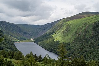
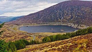
Wicklow Mountains National Park is a 205-square-kilometre (51,000-acre) protected area in Ireland, one of eight national parks in the country. The park stretches through County Wicklow as well as small areas of South Dublin and Dún Laoghaire–Rathdown in County Dublin. The park is located in the Wicklow Mountains a short distance south of Dublin. It contains a variety of attractions that are popular with city dwellers seeking recreation, and areas visited by tourists and history enthusiasts.

Glenmacnass Waterfall is an 80-metre high waterfall situated at the head of the Glenmacnass Valley in the Wicklow Mountains in Ireland. The Glenmacnass Waterfall is a popular tourist destination and scenic viewpoint area in the Wicklow Mountains. The Waterfall is bounded to the west by Tonelagee, and to the east by Scarr mountain. The entire Glenmacnass Valley can be accessed by the R115 road, which connects the Sally Gap in the north, to the village of Laragh in the south.
The Turlough Hill Power Station is a pumped storage power station in Ireland, owned and operated by the Electricity Supply Board (ESB).