N18 road (Ireland)

Last updated

IRL N18.svg
N18 road
Bóthar N18
Route information
Part of E-20 euroroute IE.png
Length98.47 km (61.19 mi)
Location
Country Ireland
Primary
destinations
(bypassed routes in italics)
Highway system

The N18 road is a national primary road in Ireland, connecting the cities of Limerick and Galway. Ennis and Gort are two major towns on the route, and Shannon Airport is reached via the connecting N19. The west coast route continues on to Sligo as the N17. The section from Limerick to the N19 junction forms part of European route E20, and the entire route is part of the proposed Atlantic Corridor. [1] The section of motorway from Shannon to Claregalway is designated the M18 motorway . The tolled Limerick Tunnel forms part of the route.

Contents

Route

Looking South from the Ennis junction flyover. This section of HQDC has been redesignated as motorway, effective 28/8/09. N18 looking south from the Ennis junction.jpg
Looking South from the Ennis junction flyover. This section of HQDC has been redesignated as motorway, effective 28/8/09.

N18 Limerick to Shannon

As of 27 July 2010, the N18 commences at the Rosbrien interchange, a major interchange south of Limerick city, where it joins the M7 motorway to Dublin and M20 motorway towards Cork and Tralee. The dual carriageway continues north, intersecting with the N69 road, before crossing under the River Shannon using the Limerick Tunnel, this section of the route forms phase II of the Limerick Southern Ring Road and is tolled between junctions 2-4. North of the River Shannon the N18 continues as dual-carriageway bypassing Cratloe, Sixmilebridge and Bunratty. The road passed alongside Bunratty Castle before the completion of the neighbouring dual-carriageway section in the late 1980s/early 1990s. The other nearby junctions were also converted to fly-overs in the 1990s.

Travelling Southbound on the N18 near the Shannon Town/Airport exit. N18 Southbound Near Shannon.jpg
Travelling Southbound on the N18 near the Shannon Town/Airport exit.

The road continues north with junctions at Hurler's Cross and Shannon Town, there is a fly-over connecting Shannon Airport via the N19 dual-carriageway.

M18 Shannon to Gort

The N18 continues north of the N19 junction where motorway regulations are enforced and the N18 route is designated as the M18 bypassing the towns of Newmarket-on-Fergus, Ennis and Gort. The motorway currently ends at Gort where the route continues as a single carriageway through County Galway. The dual-carriageway between Shannon and Ennis (including the Ennis bypass) was included in the second tranche of motorway redesignations and gained motorway status on 28 August 2009. [2]

M18 Gort to Claregalway

The Gort to Tuam (M18/M17) scheme consists of 53.2 km (33.1 mi) of motorway and 4.2 km (2.6 mi) of Type 2 dual-carriageway. DirectRoute (Tuam) Ltd., a consortium consisting of Marguerite Fund, InfraRed Capital Partners, Sisk Group, Lagan Construction Group, Roadbridge and Strabag [3] began construction of the scheme in 2015 and was officially opened on 27 September 2017.

It completed the existing M18 motorway, bypassing the towns of Kilcolgan and Oranmore. The route then continues north to the M6 Dublin Galway motorway, forming interchange junction 19 on the M6. It then continues northwards bypassing Claregalway. The M18 had terminated at a temporary junction near Gort. In addition, a new section of the N17 was constructed as motorway. This motorway begins at a new junction with the M6 near Athenry, and ends with a dual-carriageway bypass of Tuam, which was also constructed as part of the scheme but was not designated a motorway. The N17 then continues into County Mayo towards Sligo.
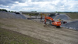
History

Gort-Crusheen under construction (June 2009): The grade separated junction at Gort. M18 Gort GSJ.jpg
Gort-Crusheen under construction (June 2009): The grade separated junction at Gort.

Major improvements to the N18 route were made in the 2000s and 2010s. Originally the route was a narrow single carriageway route that ran through all the main towns and villages between Limerick and Claregalway where the route terminates. The first improvements involved the dualling of the Limerick, Bunratty and Shannon route. The Newmarket-on-Fergus bypass opened in December 2002 and the Ennis bypass opened in 2007. Both were redesignated as motorway in August 2009. The Limerick Tunnel and phase II of the Limerick Southern Ring Road opened in July 2010 forming a continuous motorway dual-carriageway from the N/M18 to the M7 and M20 outside Limerick. On 12 November 2010 the €207 million Gort to Crusheen (M18) bypass was opened. The remaining single carriageway sections from Gort to Claregalway have been upgraded to motorway standard and were officially opened on 27 September 2017.

Junctions

IRL N18.svg
(Junctions numbered south to north)
Northbound exitJunctionSouthbound exit
Dual carriageway continues from M7 ( Motorway Exit 30 Ireland.PNG )
(M7 Motorway Exit 30 Ireland.PNG ) Rossbrien, Cork ( M20 Motorway Exit 1 Ireland.png )
Motorway Exit 1 Ireland.png
Rossbrien, Limerick (city centre) ( R509 ), Cork ( M20 Motorway Exit 1 Ireland.png )
Dock Road ( N69 )
Motorway Exit 2 Ireland.png
Dock Road ( N69 )
Shannon Tunnel
Coonagh West Ireland Road Toll Symbol.png
Motorway Exit 3 Ireland.PNG
Ireland Road Toll Symbol.png
Ennis Road (former N18)
Motorway Exit 4 Ireland.PNG
Ennis Road (former N18)
Cratloe, Sixmilebridge (R462)
Motorway Exit 5 Ireland.PNG
Cratloe, (Sixmilebridge) (R462)
Bunratty
Motorway Exit 6 Ireland.PNG
Bunratty
Hurler's Cross, Shannon Town, (Sixmilebridge) ( R471 )
Motorway Exit 7 Ireland.PNG
Hurler's Cross, Sixmilebridge, Shannon Town ( R471 )
Shannon Town Centre ( R471 )
Motorway Exit 8 Ireland.PNG
no access
M18 reduced motorway IE.png
Northbound exitJunctionSouthbound exit
Shannon ( N19 )
Motorway Exit 9 Ireland.PNG
Shannon ( N19 )
Newmarket-on-Fergus ( R472 )
Motorway Exit 10 Ireland.PNG
Newmarket-on-Fergus ( R472 )
Clarecastle ( R458 )
Motorway Exit 11 Ireland.PNG
Clarecastle ( R458 )
Ennis ( N85 )
Motorway Exit 12 Ireland.PNG
Ennis ( N85 )
Ennis, Scarriff, Tulla ( R352 )
Motorway Exit 13 Ireland.PNG
Ennis, Scarriff, Tulla ( R352 )
Ennis ( R458 )
Motorway Exit 14 Ireland.PNG
Ennis ( R458 )
Crusheen ( R458 )
Motorway Exit 15 Ireland.PNG
Crusheen ( R458 )
Gort ( R458 )
Motorway Exit 16 Ireland.PNG
Gort ( R458 )
Kiltiernan
Motorway Exit 17 Ireland.PNG
Kiltiernan
Galway, Athlone, Dublin ( M6 Motorway Exit 19 Ireland.PNG )
Motorway Exit 18 Ireland.PNG
Galway, Athlone, Dublin ( M6 Motorway Exit 19 Ireland.PNG )
Motorway continues as M17

See also

Related Research Articles

<span class="mw-page-title-main">Roads in Ireland</span> Overview of roads in Ireland

The island of Ireland, comprising Northern Ireland and the Republic of Ireland, has an extensive network of tens of thousands of kilometres of public roads, usually surfaced. These roads have been developed and modernised over centuries, from trackways suitable only for walkers and horses, to surfaced roads including modern motorways. Driving is on the left-hand side of the road. The major routes were established before Irish independence and consequently take little cognisance of the border other than a change of identification number and street furniture. Northern Ireland has had motorways since 1962, and has a well-developed network of primary, secondary and local routes. The Republic started work on its motorway network in the early 1980s; and historically, the road network there was once somewhat less well developed. However, the Celtic Tiger economic boom and an influx of European Union structural funding, saw national roads and regional roads in the Republic come up to international standard quite quickly. In the mid-1990s, for example, the Republic went from having only a few short sections of motorway to a network of motorways, dual carriageways and other improvements on most major routes as part of a National Development Plan. Road construction in Northern Ireland now tends to proceed at a slower pace than in the Republic, although a number of important bypasses and upgrades to dual carriageway have recently been completed or are about to begin.

The N7 road is a national primary road in Ireland, connecting Limerick and Dublin. The majority of the route is motorway standard and is designated as the M7 motorway. At the Rosbrien interchange in Limerick the route continues as the N18 dual carriageway to Galway, Shannon and Ennis. The road passes through the midlands of Ireland, and acts as a trunk route out of Dublin for the N8 and N9 national primary routes to Cork and Waterford respectively. It forms part of European route E20.

<span class="mw-page-title-main">M7 motorway (Ireland)</span> Motorway in Ireland

The M7 motorway is a motorway in Ireland. The motorway runs continuously from the outskirts of Naas in County Kildare to Rossbrien on the outskirts of Limerick city. The M7 forms part of the Dublin to Limerick N7 national primary road. The section of the motorway bypassing Naas, an 8 km stretch, was the first section of motorway to open in Ireland, in 1983. Following substantial works to extend the M7 to Limerick, by the end of 2010, the motorway replaced all of the old single-carriageway N7 route which is now designated as R445. At 166.5 km, the M7 is the longest motorway in Ireland.

<span class="mw-page-title-main">N11 road (Ireland)</span> National primary road in Ireland

The N11 road is a national primary road in Ireland, running for 129 km (80 mi) along the east side of Ireland from Dublin to Wexford. It passes close to Bray, Greystones, Wicklow, Arklow, Gorey, and Enniscorthy. Beyond Wexford, the route continues to Rosslare as the N25. The road forms part of European route E01. As of July 2019 the N11/M11 is of dual carriageway or motorway standard from Dublin as far as Oilgate in County Wexford.

<span class="mw-page-title-main">National Development Plan</span> Large infrastructure developments in Ireland

National Development Plan was the title given by the Irish Government to a scheme of organised large-scale expenditure on (mainly) national infrastructure. The first five-year plan ran from 1988 to 1993, the second was a six-year plan from 1994 to 1999 and the third ran as a seven-year plan from 2000 to 2006. A fourth National Development Plan ran from 2007 to 2011. The main elements of the third plan were the development of a national motorway network between the major cities in Ireland. The upgrading of the rail network was a secondary scheme.

<span class="mw-page-title-main">N4 road (Ireland)</span> National primary road from Dublin to Sligo in Ireland

The N4 road is a national primary road in Ireland, running from Dublin to the northwest of Ireland and Sligo town. The M6 to Galway diverges from this route after Kinnegad, while the N5 to Westport diverges at Longford town. Most sections of the N4 that are motorway-standard are designated the M4 motorway.

<span class="mw-page-title-main">N6 road (Ireland)</span> Road in Ireland

The N6 road is a national primary road in Ireland from junction 11 on the M4 motorway at Kinnegad to Galway city. The N6 and N4 form a continuous motorway or dual carriageway from Dublin city centre to Galway City passing in an east–west direction through the midlands of Ireland. Most of the road is motorway standard with the exception of the Athlone bypass and stretches of urban road in Galway City, which are the only sections of the road that remain designated as N6 dual carriageway. There is one toll on the road outside Galway city. Major upgrades to the road were completed in December 2009 completing the first intercity motorway/dual carriageway in Ireland and the New Junctions of M6 are built and will be 164 km.

<span class="mw-page-title-main">N17 road (Ireland)</span> Road between counties Galway and Sligo in Ireland

The N17 road is a national primary road in Ireland, and is part of the Atlantic Corridor route. It begins in County Galway and ends in County Sligo. On 27 September 2017 the southern, Tuam–Galway, section was upgraded to motorway status and designated M17.

<span class="mw-page-title-main">N21 road (Ireland)</span> Road in Ireland

The N21 road is a national primary road in Ireland. The route runs from the M20 outside Limerick to Tralee with connecting roads to other parts of County Kerry. It is 84.37 km (52.43 mi) in length. It runs through the towns of Abbeyfeale, Newcastle West, Adare and the village of Templeglantine. Prior to October 2010 the N21 also ran through the town of Castleisland. The town has since been bypassed. Rathkeale was also bypassed in 1992.

<span class="mw-page-title-main">N19 road (Ireland)</span> Road in Ireland

The N19 road is a national primary road in Ireland, connecting from the N18 Limerick–Ennis–Galway road to Shannon Airport. It forms part of European route E20.

<span class="mw-page-title-main">N20 road (Ireland)</span> Road linking Cork and Limerick in Ireland

The N20 road is a national primary road in Ireland, connecting the cities of Cork and Limerick. Buttevant, Croom, Charleville, Mallow and Blarney are major towns along the route. A short section of the route is motorway standard and is designated as the M20 Motorway.

<span class="mw-page-title-main">R445 road (Ireland)</span> Road in Ireland

The R445 road is a regional road in Ireland. The route is a non-motorway alternative route to the N7/M7 motorway between Naas and Limerick, and at 170 km it is one of the longest regional roads in Ireland. Indeed, much of the route comprises roads that were formerly part of the N7 between the cities, prior to motorway and other bypasses. Some of the R445 route also comprises local link roads to new N7/M7 route sections.

<span class="mw-page-title-main">National secondary road</span> Road classification system in Ireland

A national secondary road is a category of road in Ireland. These roads form an important part of the national route network but are secondary to the main arterial routes which are classified as national primary roads. National secondary roads are designated with route numbers higher than those used for primary roads, but with the same "N" prefix. Routes N51 and higher are all national secondary roads.

<span class="mw-page-title-main">National primary road</span> Major road in Ireland

A national primary road is a road classification in Ireland. National primary roads form the major routes between the major urban centres. There are 2649 km of national primary roads. This category of road has the prefix "N" followed by one or two digits. Motorways are prefixed "M" followed by one or two digits.

<span class="mw-page-title-main">N66 road (Ireland)</span> Road in Ireland

The N66 road was a national secondary road in Ireland.

<span class="mw-page-title-main">Atlantic Corridor</span> Proposed road project in Ireland

The Atlantic corridor or Atlantic motorway is a proposed road project in Ireland. The scheme, announced in 2005, was intended to link Waterford in the South-East to Letterkenny in the North-West via motorway or dual carriageway by 2015. However, in part due to the post-2008 Irish economic downturn, major sections of the roadway were delayed or cancelled.

<span class="mw-page-title-main">M6 motorway (Ireland)</span> Road in Ireland

The M6 motorway is a motorway in Ireland, which runs from Dublin to Galway. The M6 extends from its junction with the M4 at Kinnegad all the way west to the outskirts of Galway City, but the Athlone bypass and the approach to Galway city - while of dual carriageway standard - have not been designated motorway and are still signed as N6. The motorway was officially completed and opened to traffic on 18 December 2009, and was the first city-to-city direct major inter-urban route to be completed in Ireland. The M6 and M4, which form the Galway-Dublin route, consist of a grade-separated 2+2 dual carriageway road with a top speed limit of 120 km/h. At approximately 144 km (90 mi), the M6 is the third longest motorway in the state and will be 159 km.

<span class="mw-page-title-main">Motorways in the Republic of Ireland</span>

In Ireland, the highest category of road is a motorway, indicated by the prefix M followed by a one- or two-digit number. The motorway network consists entirely of motorway-grade dual carriageways and is largely focused upon Dublin. There are also several three-lane motorways, while Ireland's busiest road, the M50, incorporates four-lane, five-lane, and six-lane stretches.

<span class="mw-page-title-main">M18 motorway (Ireland)</span> Motorway linking Shannon and the Galway area

The M18 motorway is an inter-urban motorway in Ireland, forming part of the Limerick, Ennis to Galway national primary road, which, in turn, forms part of the Atlantic Corridor called for as part of the Transport 21 project.

<span class="mw-page-title-main">M17 motorway (Ireland)</span> Motorway linking Tuam to the M6 in Ireland

The M17 motorway is an inter-urban motorway in Ireland, forming part of the Sligo to Galway national primary road.

References

  1. Atlantic Corridor Archived 2008-12-16 at the Wayback Machine
  2. "Archived copy" (PDF). Archived from the original (PDF) on 15 June 2011. Retrieved 5 August 2009.{{cite web}}: CS1 maint: archived copy as title (link)
  3. "Gort to Tuam Motorway". DirectRoute. Archived from the original on 21 February 2020. Retrieved 22 June 2020.