R504 road (Ireland)

Last updated

R504 Regional Route Shield Ireland.png

R504 road
Route information
Length 7 km (4 mi)
Location
Primary
destinations
Road network

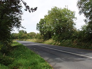
The R504 road is a regional road in Ireland which runs north-south from Birdhill to its junction with the R503 at Shower Cross, one kilometre west of the town of Newport, all in County Tipperary. En route it passes through Clery's Cross and Barna Cross, and crosses over the M7 motorway.

Regional road (Ireland) Class of road in Ireland

A regional road in Ireland is a class of road not forming a major route, but nevertheless forming a link in the national route network. There are over 11,600 kilometres of regional roads. Regional roads are numbered with three-digit route numbers, prefixed by "R".

Republic of Ireland Ireland, a country in north-western Europe, occupying 5/6 of the island of Ireland; succeeded the Irish Free State (1937)

Ireland, also known as the Republic of Ireland, is a country in north-western Europe occupying 26 of 32 counties of the island of Ireland. The capital and largest city is Dublin, which is located on the eastern side of the island. Around a third of the country's population of 4.8 million people resides in the greater Dublin area. The sovereign state shares its only land border with Northern Ireland, a part of the United Kingdom. It is otherwise surrounded by the Atlantic Ocean, with the Celtic Sea to the south, St George's Channel to the south-east, and the Irish Sea to the east. It is a unitary, parliamentary republic. The legislature, the Oireachtas, consists of a lower house, Dáil Éireann, an upper house, Seanad Éireann, and an elected President who serves as the largely ceremonial head of state, but with some important powers and duties. The head of government is the Taoiseach, who is elected by the Dáil and appointed by the President; the Taoiseach in turn appoints other government ministers.

Birdhill Village in Munster, Ireland

Birdhill is a village in County Tipperary, Ireland. It is in the barony of Owney and Arra and is part of the parish of Newport, Birdhill and Toor in the Roman Catholic Archdiocese of Cashel and Emly. Its Irish name was historically anglicised as Knockan or Knockaneeneen.

The road is 7 km (4.3 mi) long.

See also

Roads in Ireland

The island of Ireland, comprising Northern Ireland and the Republic of Ireland, has an extensive network of tens of thousands of kilometres of public roads, usually surfaced. These roads have been developed and modernised over centuries, from trackways suitable only for walkers and horses, to surfaced roads including modern motorways. The major routes were established before Irish independence and consequently take little cognisance of the border other than a change of identification number and street furniture. Northern Ireland has had motorways since 1962, and has a well-developed network of primary, secondary and local routes. The Republic started work on its motorway network in the early 1980s; and historically, the road network there was once somewhat less well developed. However, the Celtic Tiger economic boom and an influx of European Union structural funding, saw national roads and regional roads in the Republic come up to international standard quite quickly. In the mid-1990s, for example, the Republic went from having only a few short sections of motorway to a network of motorways, dual carriageways and other improvements on most major routes as part of a National Development Plan. Road construction in Northern Ireland now tends to proceed at a slower pace than in the Republic, although a number of important bypasses and upgrades to dual carriageway have recently been completed or are about to begin.

National primary road Ireland

A national primary road is a road classification in Ireland. National primary roads form the major routes between the major urban centres. There are 2649 km of national primary roads. This category of road has the prefix "N" followed by one or two digits. Motorways are prefixed "M" followed by one or two digits.

National secondary road Wikimedia list article

A national secondary road is a category of road in Ireland. These roads form an important part of the national route network, but are secondary to the main arterial routes which are classified as national primary roads. National secondary roads are designated with route numbers higher than those used for primary roads, but with the same "N" prefix. Routes N51 and higher are all national secondary roads.

Related Research Articles

R113 road (Ireland)

The R113 road is a regional road in Ireland. Located in Dublin, it forms a semi-orbital route around the south of the city. As of 2007, clockwise, it starts at the N31 at Temple Hill in Blackrock and ends at a junction with the N4 at Palmerstown.

R445 road (Ireland)

The R445 road is a regional road in Ireland. The route is a non-motorway alternative route to the N7/M7 motorway between Naas and Limerick, and at 170 km it is one of the longest regional roads in Ireland. Indeed, much of the route comprises roads that were formerly part of the N7 between the cities, prior to motorway and other bypasses. Some of the R445 route also comprises local link roads to new N7/M7 route sections.

R774 road (Ireland)

The R774 road is a regional road in County Wicklow, Ireland, which has been named the Farenkelly Road. It is a 4.7 km (2.9 mi) dual-carriageway that connects the town of Greystones with the N11 national primary road at J11.

R684 road (Ireland)

The R684 road is a regional road in Ireland. Located in the south of Ireland near Waterford City, it links the junction with the R683 at Blenheim Cross to the village of Dunmore East in County Waterford.

R415 road (Ireland)

The R415 road is a regional road in Ireland, which runs north-south from its junction with the R403 in Allenwood to the R448 at Crookstown, passing through Kildare town, and crossing the N78 between Kilcullen and Athy. The route is entirely within County Kildare.

R363 road (Ireland)

The R363 road is a regional road in Ireland linking Newbridge, County Galway to the R362 west of Athlone. It passes through Ballynamore Bridge where it crosses the River Shiven. It then crosses the River Suck into County Roscommon at Ballyforan and goes through Dysart, County Roscommon before terminating.

R817 road (Ireland)

The R817 road is a suburban road in south Dublin, Ireland connecting Harold's Cross to Ballyboden via Kimmage, Templeogue, and Ballyroan.

R507 road (Ireland)

The R507 road is a regional road in the east of County Limerick, Ireland which runs south-north from its junction with the N24 national road at Cluggin Cross and its junction with the R505 regional road in the village of Doon.

R810 road (Ireland)

The R810 road is a regional road in south Dublin, Ireland connecting Cornmarket to the Naas Road (N7).

R106 road (Ireland)

The R106 road is a regional road in north Dublin, Ireland. It runs from Sutton, passing Baldoyle, Portmarnock and Malahide before finishing in Swords.

R120 road (Ireland)

The R120 road is a regional road in south County Dublin, Ireland. It runs from Lucan, County Dublin to Rathcoole.

R121 road (Ireland)

The R121 road is a regional road in south County Dublin and Fingal, Ireland.

R127 road (Ireland)

The R127 road is a regional road in Fingal, Ireland.

R128 road (Ireland)

The R128 road is a regional road in Fingal, Ireland.

R312 road (Ireland)

The R312 road is a regional road in northwest County Mayo in Ireland. It connects the R311 road at Derrycoosh to the N59 road at Bellacorick, 36.5 kilometres (22.7 mi) away.

R767 road (Ireland)

The R767 road is a regional road in Ireland which connects J7 of the N11 to Bray Town Hall on Bray Main Street. The majority of the road is known as the Killarney Road.

R768 road (Ireland)

The R768 road is a regional road in Ireland which connects J7 of the N11 to the junction of the R761 at Irishtown, Bray. The road is commonly known as the Southern Cross or the Southern Bypass, though it is officially known as the Southern Ring Road.

R495 road (Ireland)

The R495 is a regional road in Ireland. Running entirely within County Tipperary it starts in Nenagh at Richmond Cross, a junction with the R494 and ends at Dromineer on the shores of Lough Derg. The road is approximately 7.6 km (4.7 mi) long passing through Ballycommon, Carrkirk, Annaghly Cross and Ballyartella.

R763 road (Ireland)

The R763 road is a regional road in County Wicklow in Ireland. It connects the R764 road near Ashford to the R755 road at Annamoe, 10.8 kilometres (6.7 mi) away.

R346 road (Ireland)

The R346 road is a regional road in County Mayo in Ireland. It connects the R345 near Cong to the R334 near Cross, 3.9 kilometres (2.4 mi) away.

References