The R148 road is one of Ireland's regional roads which was classified following the opening of a bypassed national primary road.

The R445 road is a regional road in Ireland. The route is a non-motorway alternative route to the N7/M7 motorway between Naas and Limerick, and at 170 km it is one of the longest regional roads in Ireland. Indeed, much of the route comprises roads that were formerly part of the N7 between the cities, prior to motorway and other bypasses. Some of the R445 route also comprises local link roads to new N7/M7 route sections.

The R132 road is one of Ireland's newest regional roads, having been classified following the opening M1 motorway which by-passes most of the old N1 route. The R132 is 98.9 kilometres (61.5 mi) long.

The R135 road is one of Ireland's newest regional roads, being a reclassification of those sections of the former N2 which were bypassed when the N2(M2) Ashbourne By-Pass dual carriageway opened in 2006, and when the Carrickmacross, Castleblayney & Monaghan bypasses were completed.

The R108 road is a regional road in Ireland, linking Drogheda in County Louth to Christchurch Place, Dublin.

The R110 road is a regional road in Ireland which goes from St Stephen's Green to Red Cow, Dublin. Its route is completely within the Dublin urban area.

The R448 road is a regional road in Ireland. It is the designation given to the former N9 national primary road when it was bypassed by the M9 motorway.

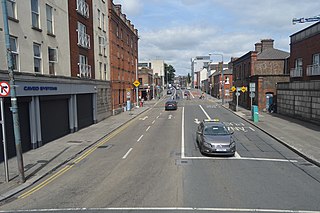
The North Circular Road, designated as the R101 regional road, is an important thoroughfare on the northside of Dublin, in Ireland. It is the northside equivalent of the South Circular Road.

The R112 road is a regional road in south Dublin, Ireland. It begins at the junction with the R148 road at Chapelizod and arcs southeastwards, then eastwards across the middle of south Dublin, ending at the Mount Merrion junction of the R138. The road is a single carriageway, with cycle lanes on some stretches. Improvements to the road have been made over the last 10 years, the most significant being at Dundrum Cross where the road was widened to make room for the new Luas bridge and Dundrum bypass.

The R114 road is a regional road in south Dublin, Ireland. The road runs from the city centre to Brittas in remote southwest County Dublin via Rathmines, Rathgar, Rathfarnham, Knocklyon, Firhouse and the mountainous area of Boharnabreena. The final stretch of the road runs just north of the border between County Dublin and County Wicklow, parallel to the Brittas River and a canal to the River Camac, which rises just to the north.

The R111 road is a regional road in south Dublin, Ireland, and includes a major element of the Dublin Outer Orbital Route.

The R105 road is a regional road in north Dublin, Ireland. It travels from the city centre to Howth, and loops at both ends; the road fully encircles Howth Head. Along the way, the road passes through Fairview, the western end of Clontarf, Killester, Raheny, the coastal edge of Kilbarrack and Sutton. Its biggest component is Howth Road.

The R121 road is a regional road in south County Dublin and Fingal, Ireland.

The R122 road is a regional road in Dublin, Ireland.

The R126 road is a regional road in Fingal, Ireland.

The R131 road is a regional road in Dublin, Ireland.

The R802 road is a regional road in Dublin, Ireland.
The R805 road is a regional road in Dublin, Ireland.

The R813 road is a regional road in Dublin, Ireland.

The R814 road, or Lombard Street East, is a regional road in Dublin, Ireland.