The island of Ireland, comprising Northern Ireland and the Republic of Ireland, has an extensive network of tens of thousands of kilometres of public roads, usually surfaced. These roads have been developed and modernised over centuries, from trackways suitable only for walkers and horses, to surfaced roads including modern motorways. Driving is on the left-hand side of the road. The major routes were established before Irish independence and consequently take little cognisance of the border other than a change of identification number and street furniture. Northern Ireland has had motorways since 1962, and has a well-developed network of primary, secondary and local routes. The Republic started work on its motorway network in the early 1980s; and historically, the road network there was once somewhat less well developed. However, the Celtic Tiger economic boom and an influx of European Union structural funding, saw national roads and regional roads in the Republic come up to international standard quite quickly. In the mid-1990s, for example, the Republic went from having only a few short sections of motorway to a network of motorways, dual carriageways and other improvements on most major routes as part of a National Development Plan. Road construction in Northern Ireland now tends to proceed at a slower pace than in the Republic, although a number of important bypasses and upgrades to dual carriageway have recently been completed or are about to begin.
The N7 road is a national primary road in Ireland, connecting Limerick and Dublin. The majority of the route is motorway standard and is designated as the M7 motorway. At the Rosbrien interchange in Limerick the route continues as the N18 dual carriageway to Shannon and Ennis. The road passes through the midlands of Ireland, and acts as a trunk route out of Dublin for the N8 and N9 national primary routes to Cork and Waterford respectively. It forms part of European route E20.
The N8 road is a national primary road in Ireland, connecting Cork with Dublin via the M7. The N8 is further classified by the United Nations as the entirety of the European route E 201, part of the trans-Europe International E-road network. The road is motorway standard from junction 19 on the M7 to the Dunkettle interchange in Cork City and is designated as the M8 motorway. From here the route continues into Cork city centre and terminates at the N22 road at St. Patrick's Street. The M8 motorway was completed in May 2010, replacing the single carriageway sections of the old N8 and bypassing towns on the main Cork to Dublin road. It is now possible to travel from Cork to Dublin on the M/N8 in about 2 hours 30 minutes. The route commences just south of Portlaoise, and reaches Cork via the midlands and the Golden Vale of Ireland, through Counties Laois, Kilkenny, Tipperary, Limerick and Cork.

The N10 road is a national primary road in Ireland, connecting Kilkenny to the M9 Dublin – Waterford route. It consists of a route from northeast of Kilkenny, a ring road around the city, and a route southeast of the city.

The N59 road is a national secondary road in Ireland. It commences in County Sligo, south of Sligo Town at the Belladrehid interchange with the N4 north of Ballysadare. The route circles around the west of Ireland, passing west from Sligo into County Mayo and through Ballina. The N59 continues around Mayo, proceeding indirectly to Westport. Continuing south through Mayo into County Galway, the road passes through the village of Leenaun. The 182-year-old bridge in the centre of the village, carrying the road across the River Lahill, collapsed in floods on 18 July 2007. Due to the local terrain and road network, the diversionary route for getting from the south of the village to Westport was 110 km long. A temporary bridge was opened eight days after the floods, on 27 July. It has since been replaced by a new bridge.
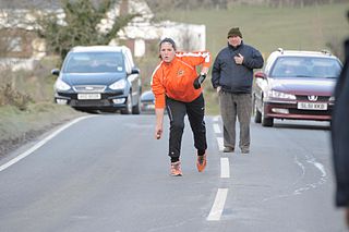
Road bowling is an Irish sport in which competitors attempt to take the fewest throws to propel a metal ball along a predetermined course of country roads. The sport originated in Ireland and is mainly played in counties Armagh and Cork. Road bowling in Ireland is governed by the voluntary Irish Road Bowling Association.

A national primary road is a road classification in Ireland. National primary roads form the major routes between the major urban centres. There are 2649 km of national primary roads. This category of road has the prefix "N" followed by one or two digits. Motorways are prefixed "M" followed by one or two digits.

The N78 road is a national secondary road in Ireland. The 50-kilometer-long (31 mi) road links the N77 national secondary road north of Kilkenny, County Kilkenny to the M9 national primary route at Mullamast in County Kildare. En route it passes through the towns of Castlecomer in County Kilkenny, Ballylynan in County Laois, and Athy in County Kildare. It is single carriageway throughout.

The M9 motorway is a motorway in Ireland linking the M7 between Naas and Newbridge near Kilcullen to Waterford. Opened in sections between 1994 and 2010, the final section opened on 9 September 2010.

The N68 road is a national secondary road in Ireland. It runs from Ennis to Kilrush. It is entirely in County Clare.

The N85 road is a national secondary road in Ireland connecting Ennis and Ennistymon. The route connects to the M18 Ennis bypass and forms part of the Ennis outer ring road as the "N85 Western Relief Road". From Ennis the route continues in a north - west direction and terminates at the junction with the N67 at Ennistymon. It is located entirely in County Clare.

The R448 road is a regional road in Ireland. It is the designation given to the former N9 national primary road when it was bypassed by the M9 motorway.

In Ireland, the highest category of road is a motorway, indicated by the prefix M followed by a one- or two-digit number. The motorway network consists entirely of motorway-grade dual carriageways and is largely focused upon Dublin. There are also several three-lane motorways, while Ireland's busiest road, the M50, incorporates four-lane, five-lane, and six-lane stretches.
The R670 road is a regional road in Ireland. The route runs from its junction with the R639 and N24 at Cloughabreeda 2 km north of Cahir through Cahir town and onwards for a further 8 km to Ardfinnan, where it joins the R665 road. The R670 is located entirely in County Tipperary.
The R397 road is a regional road in Ireland linking Longford Town to Ballymahon all in County Longford. It passes through the village of Keenagh en route. The road is 16 km (9.9 mi) long.

The R179 road is a regional road in Ireland linking Kingscourt in County Cavan and the Republic of Ireland–United Kingdom border in County Monaghan. The road passes through the villages of Magheracloone, Knocknacran, and the town of Carrickmacross. The road is 23.9 km (14.9 mi) long.
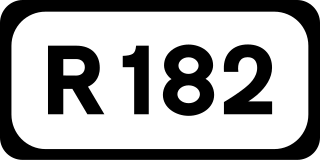
The R182 road is a regional road in Ireland linking Castleblayney and the Republic of Ireland–United Kingdom border in County Monaghan. The road continues in Northern Ireland as the A25. The road is 9.6 km (6.0 mi) long.

The R185 road is a regional road in Ireland linking the N12 near Tyholland in County Monaghan and the border with Northern Ireland. The road passes through the village of Glaslough. Across the border, it continues as an unclassified route towards the villages of Tynan and Caledon.

The R232 road is a regional road in Ireland which links Pettigo with Laghy in County Donegal.

The R480 road is a regional road in Ireland which links the N67 road with Leamaneh in County Clare.