R401 road (Ireland)

Last updated

R401 Regional Route Shield Ireland.png

R401 road
IMG R401Rathangan1257.jpg
Old signs on the R401 in Rathangan show distances in miles and the old route number, "L18"
Route information
Length42.3 km (26.3 mi)
Location
Primary
destinations
Road network

The R401 road is a regional road in Ireland, linking Kinnegad in County Meath to Kildare town in County Kildare.

Regional road (Ireland) Class of road in Ireland

A regional road in Ireland is a class of road not forming a major route, but nevertheless forming a link in the national route network. There are over 11,600 kilometres of regional roads. Regional roads are numbered with three-digit route numbers, prefixed by "R".

Republic of Ireland Country in Europe on the island of Ireland

Ireland, also known as the Republic of Ireland, is a country in north-western Europe occupying 26 of 32 counties of the island of Ireland. The capital and largest city is Dublin, which is located on the eastern side of the island. Around a third of the country's population of 4.9 million people resides in the greater Dublin area. The sovereign state shares its only land border with Northern Ireland, a part of the United Kingdom. It is otherwise surrounded by the Atlantic Ocean, with the Celtic Sea to the south, St George's Channel to the south-east, and the Irish Sea to the east. It is a unitary, parliamentary republic. The legislature, the Oireachtas, consists of a lower house, Dáil Éireann, an upper house, Seanad Éireann, and an elected President who serves as the largely ceremonial head of state, but with some important powers and duties. The head of government is the Taoiseach, who is elected by the Dáil and appointed by the President; the Taoiseach in turn appoints other government ministers.

Kinnegad Town in Leinster, Ireland

Kinnegad or Kinagad is a town in County Westmeath, Ireland. It is on the border with County Meath, near the junction of the M6 and the M4 motorways - two of Ireland's main east-west roads. It is roughly 60 km from the capital, Dublin.

Contents

The total length of the R401 is 42.3 kilometres (26.3 mi).

Route

The official description of the R401 from the Roads Act 1993 (Classification of Regional Roads) Order 2012 [1] reads:

R401: Kinnegad, County Westmeath — Edenderry, County Offaly — Kildare

Between its junction with R148 at Rossan in the county of Meath and its junction with R402 at J.K.L. Street in the town of Edenderry in the county of Offaly via Park in the county of Meath: Ballyboggan Bridge at the boundary between the county of Meath and the county of Kildare: Glynn Cross and Ballygibbon in the county of Kildare: Carrick Road and Saint Conleths Road in the town of Edenderry in the county of Offaly ( map of this 15.3 km segment ) and between its junction with R402 at Saint Mary's Road in the town of Edenderry in the county of Offaly and its junction with R415 at Station Road in the town of Kildare in the county of Kildare via Drumcooly, Ballykilleen, Clonbullogue and Coolygagan in the county of Offaly: Ballysooghan North; Main Street and Bridge Street at Rathangan; Boherkill, Rahilla Glebe; Shraud and Bohereenagorr in the town of Kildare in the county of Kildare ( map of this 27 km segment ).

R148 road (Ireland)

The R148 road is one of Ireland's regional roads which was classified following the opening of a by-passed national primary road.

County Meath County in the Republic of Ireland

County Meath is a county in Ireland. It is in the province of Leinster and is part of the Mid-East Region. It is named after the historic Kingdom of Meath. Meath County Council is the local authority for the county. At the 2016 census, the population of the county was 195,044. The county town of Meath is Navan. Other towns in the county include Trim, Kells, Laytown, Ashbourne, Dunboyne, and Slane.

R402 road (Ireland) Regional road in Ireland

The R402 road is a regional road in Ireland, linking the M4 at Enfield, County Meath to the R420 east of Tullamore in County Offaly.

See also

Roads in Ireland

The island of Ireland, comprising Northern Ireland and the Republic of Ireland, has an extensive network of tens of thousands of kilometres of public roads, usually surfaced. These roads have been developed and modernised over centuries, from trackways suitable only for walkers and horses, to surfaced roads including modern motorways. The major routes were established before Irish independence and consequently take little cognisance of the border other than a change of identification number and street furniture. Northern Ireland has had motorways since 1962, and has a well-developed network of primary, secondary and local routes. The Republic started work on its motorway network in the early 1980s; and historically, the road network there was once somewhat less well developed. However, the Celtic Tiger economic boom and an influx of European Union structural funding, saw national roads and regional roads in the Republic come up to international standard quite quickly. In the mid-1990s, for example, the Republic went from having only a few short sections of motorway to a network of motorways, dual carriageways and other improvements on most major routes as part of a National Development Plan. Road construction in Northern Ireland now tends to proceed at a slower pace than in the Republic, although a number of important bypasses and upgrades to dual carriageway have recently been completed or are about to begin.

National primary road Ireland

A national primary road is a road classification in Ireland. National primary roads form the major routes between the major urban centres. There are 2649 km of national primary roads. This category of road has the prefix "N" followed by one or two digits. Motorways are prefixed "M" followed by one or two digits.

National secondary road Wikimedia list article

A national secondary road is a category of road in Ireland. These roads form an important part of the national route network, but are secondary to the main arterial routes which are classified as national primary roads. National secondary roads are designated with route numbers higher than those used for primary roads, but with the same "N" prefix. Routes N51 and higher are all national secondary roads.

Related Research Articles

The N6 road is a national primary road in Ireland from junction 11 on the M4 motorway at Kinnegad to Galway city. The N6 and N4 form a continuous motorway or dual carriageway from Dublin city centre to Galway City passing in an east–west direction through the midlands of Ireland. Most of the road is motorway standard with the exception of the Athlone bypass and stretches of urban road in Galway City, which are the only sections of the road that remain designated as N6 dual carriageway. There is one toll on the road outside Galway city. Major upgrades to the road were completed in December 2009 completing the first intercity motorway/dual carriageway in Ireland.

R445 road (Ireland)

The R445 road is a regional road in Ireland. The route is a non-motorway alternative route to the N7/M7 motorway between Naas and Limerick, and at 170 km it is one of the longest regional roads in Ireland. Indeed, much of the route comprises roads that were formerly part of the N7 between the cities, prior to motorway and other bypasses. Some of the R445 route also comprises local link roads to new N7/M7 route sections.

Edenderry Town in Leinster, Ireland

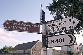
Edenderry is a town in east County Offaly, Ireland. It is near the borders with Counties Kildare, Meath and Westmeath. The Grand Canal runs along the south of Edenderry, through the Bog of Allen, and there is a short spur to the town centre.

Enfield, County Meath Enfield in Leinster, Ireland

Enfield or Innfield is a town in south County Meath, Ireland, situated between Kilcock and Kinnegad and very close to the border with County Kildare. The town is on the Dublin-Sligo railway line. It is located on the R148 regional road, formerly the N4 national primary road connecting Dublin to Connacht. In 2016, Enfield had a population of 3,239 urban residents and a few hundred rural counterparts. In the past 20 years, the village has grown considerably due to its ideal location on the commuter belt to Dublin. Similarly to many other dormitory towns in this vicinity, numerous housing estates have been constructed, and an influx of migrants from all around Ireland have settled here.

R132 road (Ireland)

The R132 road is one of Ireland's newest regional roads, having been classified following the opening M1 motorway which by-passes most of the old N1 route. The R132 is 98.9 kilometres (61.5 mi) long.

N62 road (Ireland) road in Ireland

The N62 road is a national secondary road in Ireland. It links the M6 motorway east of Athlone, County Westmeath with junction 6 of the M8 motorway at Kilnoe near Horse and Jockey in County Tipperary, 96.625 kilometres (60.040 mi) to the south. The route also forms a junction with the M7 motorway south of Roscrea.

R747 road (Ireland) road

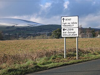
The R747 road is a regional road in Ireland running north-west/south-east from the M9 near Ballitore in County Kildare to Arklow in County Wicklow, a distance of 66 km (41 mi).

R446 road (Ireland)

The R446 road a regional road in Ireland. The road connects Kinnegad in County Westmeath to Galway City. Prior to the construction of the M6 motorway the R446 formed the main N6 road connecting Dublin and Galway. Following the opening of the M6; the old N6 road was downgraded to regional road status and was designated as the R446. The road is an alternative route between Galway and Dublin and runs in parallel to the M6.

R135 road (Ireland)

The R135 road is one of Ireland's newest regional roads, being a reclassification of those sections of the former N2 which were bypassed when the N2(M2) Ashbourne By-Pass dual carriageway opened in 2006, and when the Carrickmacross, Castleblayney & Monaghan bypasses were completed.

R108 road (Ireland)

The R108 road is a regional road in Ireland, linking Drogheda in County Louth to Christchurch Place, Dublin.

R415 road (Ireland)

The R415 road is a regional road in Ireland, which runs north-south from its junction with the R403 in Allenwood to the R448 at Crookstown, passing through Kildare town, and crossing the N78 between Kilcullen and Athy. The route is entirely within County Kildare.

R413 road (Ireland)

The R413 road is a regional road in Ireland, which runs west-east from Kildare to Ballymore Eustace, all in County Kildare. En route, it skirts, and largely demarcates, 10 km (6.2 mi) of the northern edge of the Curragh.

R448 road (Ireland)

The R448 road is a regional road in Ireland. It is the designation given to the former N9 national primary road when it was bypassed by the M9 motorway.

R125 road (Ireland)

The R125 road is a regional road in Ireland, linking Kilcock on the County Meath / County Kildare border to Swords in County Dublin via the towns of Dunshaughlin and Ratoath.

R147 road (Ireland)

The R147 is a regional road in Ireland. Its first section runs from St Peters Church in Phibsborough, Dublin to its junction with the M50. It then follows the route of a former section of the N3 between Clonee and Kells. It serves as an alternative route for non-motorway traffic and traffic wishing to avoid tolls on the M3.

R122 road (Ireland)

The R122 road is a regional road in Dublin, Ireland.

R138 road (Ireland)

The R138 road is a regional road in Ireland. It commences at the south end of O'Connell Bridge in Dublin city centre. It proceeds along D'Olier Street, College Street.

References